Gwalior is a major city in the central Indian state of Madhya Pradesh; It is known as the City of Music having oldest musical gharana in existence. It lies in northern part of Madhya Pradesh and is one of the Counter-magnet cities. Located 313 kilometres (194 mi) south of New Delhi, the capital city of India and 446 kilometres (277 mi) from Bhopal, the state capital, Gwalior occupies a strategic location in the Gird region of India. The historic city and its fortress have been ruled by several historic Indian kingdoms. From the Alchon Huns in the 5th century AD to Gurjara Pratihara dynasty in the 8th century AD. It was passed on to Kachchhapaghatas in the 10th century AD. It fell into the hands of the Delhi Sultanate in 12th century AD, it was then passed on to the Tomars in the 13th century AD who were the vassal rulers of the Delhi Sultanate. The Mughal Empire conquered the city and its fortress in the 16th century AD. When the Mughal Empire was declining, it fell into the hands of Jat rulers, then to the Maratha in 1754, and lastly it was passed on to the Scindia Dynasty of Maratha Empire in early 18th century. In April 2021, It was found that Gwalior had the best air quality index amongst the 4 major cities in Madhya Pradesh.

Datia District is one of important district in Gwalior Division in the Indian state of Madhya Pradesh. The town of Datia is its district headquarters.

Bhind district is a district in the Chambal division of the Indian state of Madhya Pradesh.

Seoni District is a district of Madhya Pradesh state in central India. The town of Seoni is the district headquarters.

Ujjain district is a district of Madhya Pradesh state in central India. The historic city of Ujjain is the district headquarters. The district has an area of 6,091 km2, and a population of 19,86,864, a 16.12% increase from its 2001 population of 17,10,982.

Lalitpur is one of the 75 districts in the northern Indian state of Uttar Pradesh. Lalitpur district is a part of Jhansi Division. Lalitpur is the main town and administrative headquarters. The district occupies an area of 5,039 km2.

Vidisha District (विदिशा) is in Madhya Pradesh state, in central India. The city of Vidisha is the administrative headquarters of the district.

Shivpuri District is a district of Madhya Pradesh state of India. The town of Shivpuri is the district headquarters. National Highway 3 (NH-3) runs through the district.

Jabalpur district is a district of Madhya Pradesh state in central India. The city of Jabalpur is the administrative headquarters of the district.

Jhansi district is one of the districts of Uttar Pradesh state in northern India. The city of Jhansi is the district headquarters. The district is bordered on the north by Jalaun District, to the east by Hamirpur and Mahoba districts, to the south by Tikamgarh District of Madhya Pradesh state, to the southwest by Lalitpur District, which is joined to Jhansi District by a narrow corridor, and on the east by the Datia and Bhind districts of Madhya Pradesh. Population 19,98,603. Lalitpur District, which extends into the hill country to the south, was added to Jhansi District in 1891, and made a separate district again in 1974.

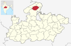
Morena district is one of the 53 districts of the central Indian state of Madhya Pradesh, located in the Chambal division.
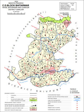
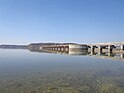
Bhitarwar is a city and a municipality in Gwalior district in the state of Madhya Pradesh, India. The town is surrounded by a river called Parbati.

Dabra is a town and municipality in Gwalior district in the state of Madhya Pradesh, India located near NH-44 national highway. It serves the headquarters for both a tehsil and a coterminous community development block.

Gwalior Rural Assembly constituency is one of the 230 Vidhan Sabha constituencies of Madhya Pradesh state in central India. This constituency came into existence in 2008, following the delimitation of the legislative assembly constituencies. It covers part of the erstwhile Morar constituency, which was abolished in 2008.

Bhitarwar Assembly constituency is one of the 230 Vidhan Sabha constituencies of Madhya Pradesh state in central India. This constituency came into existence in 2008, following the delimitation of the assembly constituencies. This constituency covers parts of the erstwhile Gird and Dabra constituencies.

Gwalior East Assembly constituency is one of the 230 Vidhan Sabha constituencies of Madhya Pradesh state in central India. This constituency came into existence in 2008, following the delimitation of the legislative assembly constituencies.

Gwalior South Assembly constituency is one of the 230 Vidhan Sabha constituencies of Madhya Pradesh state in central India. This constituency came into existence in 2008, following the delimitation of the legislative assembly constituencies.

Gwalior Assembly constituency is one of the 230 Vidhan Sabha constituencies of Madhya Pradesh state in central India. This constituency came into existence in 1951, as one of the 79 Vidhan Sabha constituencies of the erstwhile Madhya Bharat state.

Pohari Assembly constituency is one of the 230 Vidhan Sabha constituencies of Madhya Pradesh state in central India. This constituency came into existence in 1951, as Sheopur Pohri, one of the 79 Vidhan Sabha constituencies of the erstwhile Madhya Bharat state.
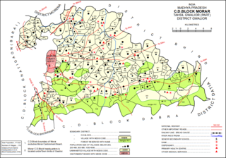
Turakpura (Turakpurá) is a village in Morar block of Gwalior district, in Madhya Pradesh, India. As of 2011, the village population is 167, in 43 households.