Bhind is a city in the Indian state of Madhya Pradesh. It is the headquarters of the Bhind district.
Rajnandgaon is a city in Rajnandgaon District, in the state of Chhattisgarh, India. As of the 2011 census the population of the city was 163,122. Rajnandgaon district came into existence on 26 January 1973, as a result of the division of Durg district.
Mursan is a town and a Nagar Panchayat in Hathras district in the Indian state of Uttar Pradesh. The primary spoken language is a dialect of Hindi, Braj Bhasha, which is closely related to Khariboli. In past, Raja Mahendra Pratap Singh was the ruler of Mursan. At present, the Chairman of Mursan is Deshraj Singh. Former King of Mursan Kingdom:
Isagarh, is a town in Ashoknagar District of Madhya Pradesh state in central India. It is the administrative headquarters of Isagarh tehsil.
Badarwas is a town and a nagar panchayat in Shivpuri district in the state of Madhya Pradesh, India. Badarwas is also known as Jacket Capital of India.
Bhander is a town and a nagar panchayat in Datia district in the state of Madhya Pradesh.
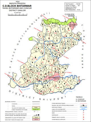
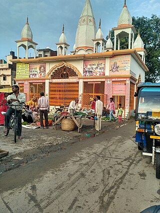
Bhitarwar is a city and a municipality in Gwalior district in the state of Madhya Pradesh, India. The town is surrounded by a river called Parbati.
Dineshpur is a town and a nagar panchayat in Udham Singh Nagar district in the state of Uttarakhand, India.

Jaura is a town and a nagar palika in Morena district in the Indian state of Madhya Pradesh.
Kiraoli is a town and a nagar panchayat in Agra district in the Indian state of Uttar Pradesh.
Kolaras is a town and a nagar parishad in Shivpuri district in the Indian state of Madhya Pradesh. Kolaras is located on NH3 presently called NH46. It is religious city and famous with name mini vrindavan.
Lahar is a city and a Nagar Palika in Bhind district in the Indian state of Madhya Pradesh.
Lasalgaon is a census town in Nashik District in the Indian state of Maharashtra.
Lauthaha is a city and a notified area in Purvi Champaran district in the Indian state of Bihar.
Nallur (Nalloor) is a panchayat town in Kanniyakumari district in the Indian state of Tamil Nadu.
Ramganj Mandi is a city and a municipality in Kota district in the Indian state of Rajasthan. It is also known by the names "Stone city" and "Coriander city". It has the largest grain market of coriander with around 6500 tons of coriander seeds arriving on a single day during season. Spices Giant MDH buys its coriander seeds from Ramganj Mandi. A new spice park is being constructed on Nimana road, the link road between SH 9B and NH 12. Annually billions of square feet of limestone is exported throughout the country, mainly in Punjab, Haryana, Chandigarh, Gujarat, Maharashtra and Madhya Pradesh. Around 1000 stone processing units are set up in the industrial area. More than 80 mines are present in the area.

Sankrail is a census town in Sankrail CD Block of Howrah Sadar subdivision in Howrah district in the Indian state of West Bengal. It is a part of Kolkata Urban Agglomeration.

Usilampatti is a town and a second grade municipality of Madurai district in the Indian state of Tamil Nadu. It is also a designated taluk and revenue division.
Vasudevanallur is a town panchayat located 37 km from Tenkasi district in the Indian state of Tamil Nadu. It is located under the Western Ghats
Ashta is a city and a municipal council in Sangli district in the state of Maharashtra, India. It is located at 16.95°N 74.4°E. It has an average elevation of 567 metres (1860 ft). The name "Ashta" comes from the legend that Lord Shri Ram established eight (Asht) Lord Mahadev temples in this area. The city is divided into 19 wards for which elections are held every 5 years. The Ashta Municipal Council has the population of 37,105 of which 19,171 are males while 17,934 are females as per the report released by Census India 2011.

