Gwalior is a major city in the central Indian state of Madhya Pradesh; It is known as the City of Music having oldest musical gharana in existence. It lies in northern part of Madhya Pradesh and is one of the Counter-magnet cities. Located 313 kilometres (194 mi) south of New Delhi, the capital city of India and 446 kilometres (277 mi) from Bhopal, the state capital, Gwalior occupies a strategic location in the Gwalior Chambal region of India. The historic city and its fortress have been ruled by several historic Indian kingdoms. From the Alchon Huns in the 5th century AD to Gurjara Pratihara dynasty in the 8th century AD. It was passed on to Kachchhapaghatas in the 10th century AD. It fell into the hands of the Delhi Sultanate in 12th century AD, it was then passed on to the Tomars in the 13th century AD who were the vassal rulers of the Delhi Sultanate. The Mughal Empire conquered the city and its fortress in the 16th century AD. When the Mughal Empire was declining, it fell into the hands of Jat rulers, then to the Maratha in 1754, and lastly it was passed on to the Scindia Dynasty of Maratha Empire in early 18th century. In April 2021, It was found that Gwalior had the best air quality index amongst the 4 major cities in Madhya Pradesh.

Mhow, officially Dr. Ambedkar Nagar, is a town in the Indore district in Madhya Pradesh state of India. It is located 23 kilometres (14 mi) south-west of Indore city, towards Mumbai on the old Mumbai-Agra Road. In 2003, the Government of Madhya Pradesh renamed the town Dr. Ambedkar Nagar, after political reformer and town native B. R. Ambedkar.

Datia, also known as Daityavakra is the district headquarter of the Datia District in north central Madhya Pradesh, a state of Central India. It is an ancient town, mentioned in the Mahabharata ruled by King Dantavakra. The city is 71 km from Gwalior, 325 km south of New Delhi and 344 km north of Bhopal. About 18 km from Datia is Sonagiri, a sacred Jaina hill. Datia is also about 52 km from Orchha. The nearest airport is at Gwalior. It was formerly the seat of the eponymous princely state in the British Raj. Datia is situated near Gwalior and on the border with Uttar Pradesh.

Bhind is a city in the Indian state of Madhya Pradesh. It is the headquarters of the Bhind district.
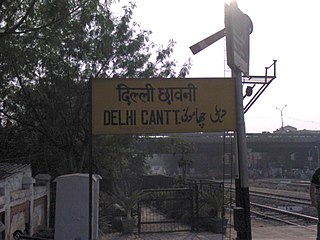
Delhi Cantonment is a Class I Cantonment Board established in 1914. The area of the Cantonment is 10,452 acres (42.30 km2) and the population of the Cantonment as per the 2011 census is 110,351.

Guna (Gwalior United National Army) is a city and a municipality in Guna district in the Indian state of Madhya Pradesh. It is the administrative headquarters of Guna District under Gwalior Division and is located on the banks of Parbati river.

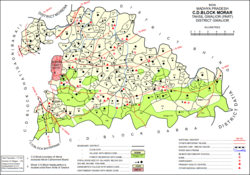
Gwalior district is one of the 52 districts of Madhya Pradesh state in central India. The historic city of Gwalior is its administrative headquarters. Other cities and towns in this district are Antari, Bhitarwar, Bilaua, Dabra, Morar Cantonment, Pichhore, and Tekanpur. The district is at the centre of the Gird region.

Jhansi district is one of the districts of Uttar Pradesh state in northern India. The city of Jhansi is the district headquarters. The district is bordered on the north by Jalaun District, to the east by Hamirpur and Mahoba districts, to the south by Tikamgarh District of Madhya Pradesh state, to the southwest by Lalitpur District, which is joined to Jhansi District by a narrow corridor, and on the east by the Datia and Bhind districts of Madhya Pradesh. Population 19,98,603. Lalitpur District, which extends into the hill country to the south, was added to Jhansi District in 1891, and made a separate district again in 1974.
Sardarpur is a town and a nagar panchayat in Dhar district in the Indian state of Madhya Pradesh. It is a town on Mahi river on the Malwa plateau. There is an ancient Shivalinga situated at the bank of Mahi river at a place called Shree Jhineshwar Dham; Shri Mohankheda Jain Thirth and Bhopawar Jain Tirth are located nearby.
Jalandhar Cantonment is a cantonment town in Jalandhar District in the Indian state of Punjab. The Cantonment is located between latitude 30° 18' and longitude 75° 37' on the southwest and at a distance of 2 km from Cantonment Railway Station and 5 km from City Railway Station. It is situated beside Grand Trunk Road at a distance of 89 km from Amritsar and 371 km from Delhi. It covers an area of 5.87 square miles (15.2 km2). It is on Amritsar-Delhi Broad Gauge Main Line. A Class-I airfield at Adampur is situated at a distance of 19 km. The airfield is linked with Jalandhar Cantonment by rail and road. It has a Recruiting Office responsible for enlisting the soldiers for Army, Navy and Air Force. The first Recruiting Officer who held this post until 1952 was Col. Dilbagh Singh Minhas of Jallandhar Doab.
Isagarh, is a town in Ashoknagar District of Madhya Pradesh state in central India. It is the administrative headquarters of Isagarh tehsil.
Ambah is a city and a municipality in Morena district in the state of Madhya Pradesh, India. It is the administrative headquarter of Ambah-Porsa Block. It was formerly known as Ambrish Nagari.Devendra Sakhwar (SC) of the Congress party is the present MLA from Ambah-Porsa Constituency.
Bhander is a town and a nagar panchayat in Datia district in the state of Madhya Pradesh.
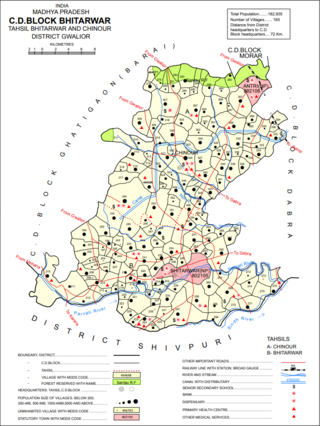
Bhitarwar is a city and a municipality in Gwalior district in the state of Madhya Pradesh, India. The town is surrounded by a river called Parbati.

Gun Carriage Factory Jabalpur, also known as GCF Jabalpur is a defence factory and a census town in Jabalpur district in the state of Madhya Pradesh, India. Located in the scenic surroundings of the Satpura Range, this small government township is built around its namesake defence establishment. It is about 3 km from the Jabalpur City railway station, and is also closely connected to the city. It is surrounded by other defense establishments. Within the estate, there are central schools, hospitals, churches, temples and clubs.

Jaura is a town and a nagar palika in Morena district in the Indian state of Madhya Pradesh.
Lahar is a city and a Nagar Palika in Bhind district in the Indian state of Madhya Pradesh.
Rajakhera is a city and a municipality situated near the banks of the Chambal River in Dholpur district in the Eastern part of the Indian state of Rajasthan. Its part of Braj region and the local language has Braj Bhasha dialect. The culture is fused with Rajasthan and its border states.
Sarangpur is a city and tehsil in Rajgarh district in the Indian state of Madhya Pradesh. It is situated at the bank of the river Kali Sindh.
Pichhore is a town and a nagar panchayat in Shivpuri district in the Indian state of Madhya Pradesh. It's also a tehsil headquarter and Development block. it's loceted in Bundelkhand region of Madhya Pradesh.