
Madhya Pradesh is a state in central India. Its capital is Bhopal, and the largest city is Indore, with Gwalior, Jabalpur, Ujjain, Dewas, Sagar, Satna, and Rewa being the other major cities. Madhya Pradesh is the second largest Indian state by area and the fifth largest state by population with over 72 million residents. It borders the states of Uttar Pradesh to the northeast, Chhattisgarh to the east, Maharashtra to the south, Gujarat to the west, and Rajasthan to the northwest.

Morena is the headquarter of Morena district in the Indian state of Madhya Pradesh. It is governed by a municipality corporation. It is also the administrative headquarters of the Chambal division. It is 39 kilometres (24 mi) from Gwalior, Madhya Pradesh.

Sheopur District is a district of Madhya Pradesh state in central India. The district is located in the north of the state and forms part of Chambal division. It is situated on the periphery of Rajasthan, which shows in the influence of Rajasthani culture in this district.

Datia District is in Gwalior Division in the Indian state of Madhya Pradesh. The town of Datia is its district headquarters.
Bhind district is a district in the Chambal division of the Indian state of Madhya Pradesh. The town of Bhind is the district headquarters. Bhind District is situated in Chambal region in the northwest of the state. It is bounded by Agra, Etawah, Jalaun and Jhansi districts of Uttar Pradesh state to the north and the east, and the Madhya Pradesh districts of Datia to the south, Gwalior to the southwest, and Morena to the west. The geography of the district is characterised by uneven ravines, plain fertile fields and scanty forests. The total area of the district is 4,459 km2 (1,722 sq mi).

Guna district is one of the 52 districts of Madhya Pradesh in central India. Its administrative headquarters is Guna. The district has a population of 1,241,519. It has an area of 6390 km², and is bounded on the northeast by Shivpuri District, on the east by Ashoknagar District, on the southeast by Vidisha District, on the southwest by Rajgarh District, on the west and northwest by Jhalawar and Baran districts of Rajasthan state. The Sindh River flows northward along the eastern edge of the district, forming part of the boundary with Ashoknagar District, and the Parvati River flows northwestward through the southern portion of the district, forming part of the boundary with Baran District before flowing into Rajasthan.

Vidisha District (विदिशा) is in Madhya Pradesh state, in central India. The city of Vidisha is the administrative headquarters of the district.

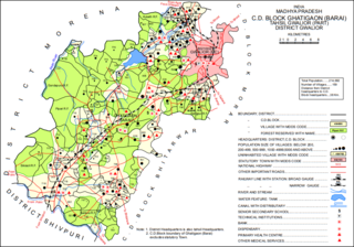
Shivpuri District is a district of Madhya Pradesh state of India. The town of Shivpuri is the district headquarters. National Highway 3 (NH-3) runs through the district.

Gwalior district is one of the 52 districts of Madhya Pradesh state in central India. The historic city of Gwalior is its administrative headquarters. Other cities and towns in this district are Antari, Bhitarwar, Bilaua, Dabra, Morar Cantonment, Pichhore, and Tekanpur. The district is at the centre of the Gird region.

Jhansi district is one of the districts of Uttar Pradesh state in northern India. The city of Jhansi is the district headquarters. The district is bordered on the north by Jalaun District, to the east by Hamirpur and Mahoba districts, to the south by Tikamgarh District of Madhya Pradesh state, to the southwest by Lalitpur District, which is joined to Jhansi District by a narrow corridor, and on the east by the Datia and Bhind districts of Madhya Pradesh. Population 19,98,603. Lalitpur District, which extends into the hill country to the south, was added to Jhansi District in 1891, and made a separate district again in 1974.
Isagarh, is a town in Ashoknagar District of Madhya Pradesh state in central India. It is the administrative headquarters of Isagarh tehsil.

Bhitarwar is a city and a Municipality in Gwalior district in the state of Madhya Pradesh, India. The town is surrounded by a river called Parbati.
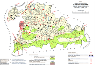
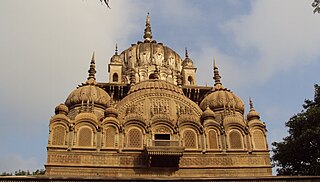
Morar Cantonment is a cantonment town in Gwalior district in the Indian state of Madhya Pradesh. It is part of an urban agglomeration together with neighbouring Gwalior. Adv. Rakesh Singh Chauhan is the longest serving Former Chairman & Vice-President of Cantonment Board Morar.

Karera is one of the 230 Vidhan Sabha constituencies of Madhya Pradesh state in central India. This constituency is reserved for the candidates belonging to the Scheduled castes. This constituency came into existence in 1951, as one of the 79 Vidhan Sabha constituencies of the erstwhile Madhya Bharat state.
Ghatigaon (Gháṭígaon) is a village and corresponding community development block in Gwalior district of Madhya Pradesh, India. As of 2011, the village population was 5,641, in 1,088 households.
Jakhara (Jakhárá) is a village in Morar block of Gwalior district, in Madhya Pradesh, India. As of 2011, the village population is 2,096, in 369 households.
Berja (Berjá) is a village in Morar block of Gwalior district, in Madhya Pradesh, India. As of 2011, the village population is 1,963, in 346 households.
Gowai (Gowaí) is a village in Morar block of Gwalior district, in Madhya Pradesh, India. As of 2011, the village population was 928, in 226 households.
Turakpura (Turakpurá) is a village in Morar block of Gwalior district, in Madhya Pradesh, India. As of 2011, the village population is 167, in 43 households.
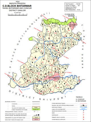
Banwar (Banwár) is a village in Bhitarwar block of Gwalior district, in Madhya Pradesh, India. As of 2011, the village population was 4,209, in 769 households. There is a weekly haat, but no mandi/regular market.


