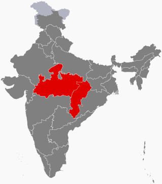
Madhya Pradesh is a state in central India. Its capital is Bhopal, and its largest city is Indore, with Jabalpur, Gwalior being the other major cities. Madhya Pradesh is the second largest Indian state by area and the fifth largest state by population with over 72 million residents. It borders the states of Uttar Pradesh to the northeast, Chhattisgarh to the east, Maharashtra to the south, Gujarat to the west, and Rajasthan to the northwest.

Gwalior is a major city in the central Indian state of Madhya Pradesh; It is known as the City of Music having oldest musical gharana in existence. It lies in northern part of Madhya Pradesh and is one of the Counter-magnet cities. Located 313 kilometres (194 mi) south of New Delhi, the capital city of India and 446 kilometres (277 mi) from Bhopal, the state capital, Gwalior occupies a strategic location in the Gird region of India. The historic city and its fortress have been ruled by several historic Indian kingdoms. From the Alchon Huns in the 5th century AD to Gurjara Pratihara dynasty in the 8th century AD. It was passed on to Kachchhapaghatas in the 10th century AD. It fell into the hands of the Delhi Sultanate in 12th century AD, it was then passed on to the Tomars in the 13th century AD who were the vassal rulers of the Delhi Sultanate. The Mughal Empire conquered the city and its fortress in the 16th century AD. When the Mughal Empire was declining, it fell into the hands of Jat rulers, then to the Maratha in 1754, and lastly it was passed on to the Scindia Dynasty of Maratha Empire in early 18th century. In April 2021, It was found that Gwalior had the best air quality index amongst the 4 major cities in Madhya Pradesh.

Madhya Bharat, also known as Malwa Union, was an Indian state in west-central India, created on 28 May 1948 from twenty-five princely states which until 1947 had been part of the Central India Agency, with Jiwajirao Scindia as its Rajpramukh.

Morena, is a town and a district in the Indian state of northern Madhya Pradesh. The place gets its name from “mor” (peacock) and “raina”- which means a place where peacocks are found in abundance and is home to the largest number of peacocks in India.

Chanderi, is a town of historical importance in Ashoknagar District of the state Madhya Pradesh in India. It is situated at a distance of 127 km from Shivpuri, 37 km from Lalitpur, 55 km from Ashok Nagar and about 46 km from Isagarh. It is surrounded by hills southwest of the Betwa River. Chanderi is surrounded by hills, lakes and forests and is spotted with several monuments of the Bundela Rajputs. It is famous for ancient Jain Temples. Its population in 2011 was 33,081.
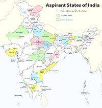
Central India is a loosely defined geographical region of India. There is no clear official definition and various ones may be used. One common definition consists of the states of Chhattisgarh and Madhya Pradesh, which are included in almost all definitions. Like some other definitions this takes the part of northern India that is "central" on an east–west axis. Thus the Central Zonal Council set up by the Indian government includes both these states, plus Uttar Pradesh and Uttarakhand to the north, the last taking the region to the border with Tibet/China in the Himalayas.

Lalitpur is one of the 75 districts in the northern Indian state of Uttar Pradesh. Lalitpur district is a part of Jhansi Division. Lalitpur is the main town and administrative headquarters. The district occupies an area of 5,039 km2.

Gwalior district is one of the 52 districts of Madhya Pradesh state in central India. The historic city of Gwalior is its administrative headquarters. Other cities and towns in this district are Antari, Bhitarwar, Bilaua, Dabra, Morar Cantonment, Pichhore, and Tekanpur. The district is at the centre of the Gird region.

Gwalior Division is an administrative subdivision of Madhya Pradesh state in central India. It includes the districts of Ashoknagar, Datia, Guna, Gwalior, and Shivpuri. The historic city of Gwalior is the administrative headquarters of the division.

Jhansi district is one of the districts of Uttar Pradesh state in northern India. The city of Jhansi is the district headquarters. The district is bordered on the north by Jalaun District, to the east by Hamirpur and Mahoba districts, to the south by Tikamgarh District of Madhya Pradesh state, to the southwest by Lalitpur District, which is joined to Jhansi District by a narrow corridor, and on the east by the Datia and Bhind districts of Madhya Pradesh. Population 19,98,603. Lalitpur District, which extends into the hill country to the south, was added to Jhansi District in 1891, and made a separate district again in 1974.

Chanderi District was a former administrative district of British India. It covered most of present-day Lalitpur district of Uttar Pradesh state and the eastern portion of Ashoknagar District of Madhya Pradesh state.
Rajakhera is a city and a municipality situated near the banks of the Chambal River in Dholpur district in the Eastern part of the Indian state of Rajasthan. Its part of Braj region and the local language has Braj Bhasha dialect. The culture is fused with Rajasthan and its border states.

Gwalior is one of the 29 Lok Sabha constituencies in the Indian state of Madhya Pradesh state. This constituency covers the entire Gwalior district and part of Shivpuri district.

Gwalior Rural Assembly constituency is one of the 230 Vidhan Sabha constituencies of Madhya Pradesh state in central India. This constituency came into existence in 2008, following the delimitation of the legislative assembly constituencies. It covers part of the erstwhile Morar constituency, which was abolished in 2008.

Bhitarwar Assembly constituency is one of the 230 Vidhan Sabha constituencies of Madhya Pradesh state in central India. This constituency came into existence in 2008, following the delimitation of the assembly constituencies. This constituency covers parts of the erstwhile Gird and Dabra constituencies.

Gwalior East Assembly constituency is one of the 230 Vidhan Sabha constituencies of Madhya Pradesh state in central India. This constituency came into existence in 2008, following the delimitation of the legislative assembly constituencies.

Gwalior South Assembly constituency is one of the 230 Vidhan Sabha constituencies of Madhya Pradesh state in central India. This constituency came into existence in 2008, following the delimitation of the legislative assembly constituencies.

Gwalior Assembly constituency is one of the 230 Vidhan Sabha constituencies of Madhya Pradesh state in central India. This constituency came into existence in 1951, as one of the 79 Vidhan Sabha constituencies of the erstwhile Madhya Bharat state.

Karera is one of the 230 Vidhan Sabha constituencies of Madhya Pradesh state in central India. This constituency is reserved for the candidates belonging to the Scheduled castes. This constituency came into existence in 1951, as one of the 79 Vidhan Sabha constituencies of the erstwhile Madhya Bharat state.

The Gujari Mahal Archeological Museum or State Archaeological Museum, sometimes called the "Gwalior Fort Museum", is a state museum in Gwalior, located in the fortress of Gujari Mahal. It displays numerous artifacts of the region, including a fragment of the Garuda capital of the Heliodorus pillar from Vidisha.