Bagelkhand

Last updated

Baghelkhand
Region
Purva Falls formed by Tons River.jpg
Govindgarh fort backside view, Rewa.jpg
Chitrakoot (4750024971).jpg
Shiva temple and monastery, Chandreh Rampur Naikin, Madhya Pradesh 10.jpg
0101022 Virateshwar temple, Sohagpur, Madhya Pradesh 008.jpg
Keoti falls in Rewa, Madhya Pradesh.jpg
Top to Bottom; Left to Right: Purwa Falls, Govindgarh Palace, Ramghat at Chitrakoot, Chandreh Temple at Naikin, Virateshwara Temple at Sohagpur and Keoti Falls
India Bagelkhand locator map.svg
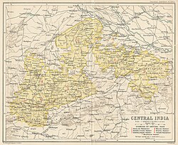
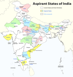
Location of Baghelkhand in India
Madhya Pradesh location map.svg
Red pog.svg
Baghelkhand
Location of Baghelkhand
India location map.svg
Red pog.svg
Baghelkhand
Baghelkhand (India)
Coordinates: 24°30′N81°12′E / 24.5°N 81.2°E / 24.5; 81.2
CountryFlag of India.svg  India
State Madhya Pradesh and Uttar Pradesh
Covering territory
Languages Bagheli language
Area
  Total42,179 km2 (16,285 sq mi)
Population
 (2011)
  Total10,351,135
  Density250/km2 (640/sq mi)

Bagelkhand or Baghelkhand is a proposed state and a mountain range in central India that covers the northeastern regions of Madhya Pradesh and a small area of southeastern Uttar Pradesh.

Contents

History

Dahala

Baghelkhand was known as Dahala in the 6th–12th century. The area got its current name after Vaghela Rajput kings in the 14th century, later it was absorbed state. [1]

Bagelkhand Agency

The Bagelkhand Agency was a British political unit which managed the relations of the British with a number of autonomous princely states existing outside British India, namely Singrauli (Venvanshi), Rewa and 11 minor states, of which the most prominent were Maihar, Nagod and Sohawal. Other principalities included Jaso, Kothi, Baraundha (aka Patharkachhar) as well as the Kalinjar Chaubes, consisting of the princely estates of Paldeo, Kamta-Rajaula, Tarauwhan, Pahra and Bhaisaunda. [2]

Central India Agency Map Central India Agency Map.jpg
Central India Agency Map

Geography

Bagelkhand is surrounded by the Indo-Gangetic plains in the north and east, Bundelkhand in the west and the Vindhya range in the south. [1]

Regions of Uttar Pradesh UP region map.gif
Regions of Uttar Pradesh

Administration

Currently it divided between Madhya Pradesh and Uttar Pradesh. It includes the Madhya Pradesh districts Rewa, Satna, Shahdol, Sidhi of Madhya Pradesh and Chitrakoot of Uttar Pradesh. [1]

Demographics

The inhabitants of Bagelkhand are called Bagheli and they speak the Bagheli language which is also designated as a dialect of Hindi. [1]

Religion in Baghelkhand (2011) [3]
ReligionPercent
Hinduism
95.48%
Islam
3.42%
Others
1.10%
Languages in Baghelkhand (2011) [4]
LanguagePercent
Hindi
65.59%
Bagheli
25.33%
Bundeli
3.20%
Urdu
0.17%
Others
5.71%

Related Research Articles

<span class="mw-page-title-main">Madhya Pradesh</span> State in central India

Madhya Pradesh is a state in central India. Its capital is Bhopal, and the largest city is Indore, with Gwalior, Jabalpur, Ujjain, Dewas, Sagar, Satna, and Rewa being the other major cities. Madhya Pradesh is the second largest Indian state by area and the fifth largest state by population with over 72 million residents. It borders the states of Uttar Pradesh to the northeast, Chhattisgarh to the east, Maharashtra to the south, Gujarat to the west, and Rajasthan to the northwest.

<span class="mw-page-title-main">Bagheli language</span> Indo-Aryan language spoken in India

Bagheli or Baghelkhandi is a Central Indo-Aryan language spoken in the Baghelkhand region of central India.

<span class="mw-page-title-main">Vindhya Pradesh</span> Former State of India

Vindhya Pradesh was a former state of India. It occupied an area of 61,131.5 km2. It was created in 1948 as Union of Baghelkhand and Bundelkhand States, shortly after Indian independence, from the territories of the princely states in the eastern portion of the former Central India Agency. It was named as Vindhya Pradesh on 25 January 1950 after the Vindhya Range, which runs through the centre of the province. The capital of the state was the former princely state of Rewa. It lays between Uttar Pradesh to the north and Madhya Pradesh to the south, and the enclave of Datia, which lay a short distance to the west, was surrounded by the state of Madhya Bharat.

<span class="mw-page-title-main">Central India Agency</span> Agency of princely states in India

The Central India Agency was created in 1854, by amalgamating the Western Malwa Agency with other smaller political offices which formerly reported to the Governor-General of India. The agency was overseen by a political agent who maintained relations of the Government of India with the princely states and influence over them on behalf of the Governor-General. The headquarters of the agent were at Indore.

<span class="mw-page-title-main">Rewa, Madhya Pradesh</span> City in Madhya Pradesh, India

Rewa is a city in the north-eastern part of Madhya Pradesh state in India. It is the administrative center of Rewa District and Rewa Division. The city lies about 420 kilometres (261 mi) northeast of the state capital Bhopal and 230 kilometres (143 mi) north of the city of Jabalpur. The maximum length of Rewa district is 125 km from east to west and the length of Rewa from north to south is 96 km. This area is surrounded by Kaimur hills to the south Vindhyachal ranges pass through the middle of the district.

<span class="mw-page-title-main">Prayagraj district</span> District of Uttar Pradesh in India

Prayagraj district, also known as Allahabad district, is the most populous district in the Indian state of Uttar Pradesh. Prayagraj city is the district headquarters of this district. The District is divided into blocks within tehsils. As of 2011, there are 20 blocks in eight tehsils. The Prayagraj division includes the districts of Pratapgarh, Fatehpur, Kaushambi and Prayagraj, with some western parts that had previously part of Allahabad District becoming part of the new Kaushambi District. The administrative divisions are Phulpur, Koraon, Meja, Sadar, Soraon, Handia, Bara, Shringverpur and Karchana.

<span class="mw-page-title-main">Panna district</span> District of Madhya Pradesh in India

Panna district is a district of the Sagar Division, within the Madhya Pradesh state in central India. The town of Panna is the district headquarters.

<span class="mw-page-title-main">Rewa district</span> City and district of Madhya Pradesh in India

Rewa district is a district of the Madhya Pradesh state in central India. The city of Rewa is the district headquarter. Rewa is sometimes called – 'Land of White Tigers' as the first White Tiger was discovered here in 1951 by Maharaja of the province, Martand Singh in the nearby jungle of Govindgarh. Rewa was the capital city of once a state – Vindhya Pradesh.

<span class="mw-page-title-main">Shahdol district</span> District of Madhya Pradesh in India

Shahdol District is a district of Madhya Pradesh state in east central India. It old name was Matsya raj or Virat kingdom in the name of great king Maharaja Virata. With a total area of 6,205 km2 (2,396 sq mi) and a population of 10,66,063. Shahdol is an important district of Madhya Pradesh. The town of Shahdol is the district headquarters. The district formerly comprised Shahdol division.

<span class="mw-page-title-main">Sidhi district</span> District of Madhya Pradesh in India

Sidhi District is one of the tribal districts of Madhya Pradesh state of India. The town of Sidhi is the district headquarters. The district is part of Rewa Division.

<span class="mw-page-title-main">Rewa division</span> Administrative division of Madhya Pradesh, India

Rewa Division is an administrative geographical unit of Madhya Pradesh state of India situated in the northeast part of state bordering with Uttar Pradesh, Chhattisgarh and Baghelkhand region of Madhya Pradesh. Rewa is the administrative headquarters of the division. As of 2010, the division consists of districts of Rewa, Satna, Sidhi, Singrauli, Mauganj and Maihar. The division forms a part of the Baghelkhand region of Madhya Pradesh. The divisional headquarters in the Kothi Compound area of Rewa.

Satna is a city in the Indian state of Madhya Pradesh. It serves as the headquarters of Satna district. It is 7th largest city and 8th most populous city of the state. The city is 500 km east of the state capital Bhopal. The city is distributed over a land area of 111.9 square kilometres.

<span class="mw-page-title-main">Mirzapur district</span> District in Uttar Pradesh, India

Mirzapur district is one of the 75 districts in the Indian state of Uttar Pradesh. The district is bounded on the north by Bhadohi and Varanasi districts, on the east by Chandauli district, on the south by Sonbhadra district and on the northwest by Prayagraj. The district occupies an area of 4521 km2. Mirzapur city is the district headquarters. Mirzapur district is a part of Mirzapur division. This district is known for the Vindhyavasini temple in Vindhyachal and several tourist attractions like water falls like Rajdari & Devdari and dams. It consist of several Ghats where historical sculptures are still present. During the Ganges festival these Ghats are decorated with lights and diyas.

<span class="mw-page-title-main">Rewa (princely state)</span> Princely state in India

Rewa State, also known as Rewah, was a Rajput princely state of India, surrounding its eponymous capital, the town of Rewa.

<span class="mw-page-title-main">Mauganj</span> Town in Madhya Pradesh, India

Mauganj is the 53rd district in the Indian state of Madhya Pradesh. Bagheli is the regional language of Mauganj. Mauganj is the seat of legislative assembly in Madhya Pradesh. Its nearest towns are Manikwar, Hanumana, Deotalab, Naigadhi.

<span class="mw-page-title-main">Nai Garhi</span> Place in Madhya Pradesh, India

Naigarhi is a rural town in the Rewa district of Madhya Pradesh, India. It was founded by a Sengar Rajput king, Raja Chattradhari Singh. The town is notable for its medieval era architecture constructed by the Sengar kings.

<span class="mw-page-title-main">Bagelkhand Agency</span> British political unit in India

The Bagelkhand Agency was a British political unit which managed the relations of the British with a number of autonomous princely states existing outside British India, namely Singrauli, Rewa and 11 minor states, of which the most prominent were Maihar, Nagod and Sohawal. Other principalities included Jaso, Kothi, Baraundha as well as the Kalinjar Chaubes, consisting of the princely estates of Paldeo, Kamta-Rajaula, Taraon, Pahra and Bhaisaunda.

<span class="mw-page-title-main">Satna district</span> District of Madhya Pradesh in India

Satna District is a district of Madhya Pradesh state in central India. The city of Satna is the district headquarters. The district has an area of 7,502 km², and a population of 22,28,935(2011 census), 20.63% of which is urban. The district has a population density of 249 persons per km².

<span class="mw-page-title-main">Govindgarh, Madhya Pradesh</span> City in Madhya Pradesh, India

Govindgarh, the summer capital of Mahraja Rewa, is about 18 km from Rewa in Madhya Pradesh, India. The is Rewa, with an area of about 13,000 mi², was the largest princely state in the Bagelkhand Agency and the second largest in Central India Agency. The British political agent for Bagelkhand resided at Satna, on the East Indian railway. The Bagelkhand capital establish in Rewa under the Rewa Maharaja.Bagheli is the local language of the region.It's neighbouring towns are Manikawar, Gurh and Rewa.

Sengar, also known as Sanghar, Singraur or Songar, are a clan of Rajputs in India.

References

  1. 1 2 3 4 "Baghelkhand | historical region, India". Encyclopedia Britannica. Retrieved 30 April 2020.
  2. Malleson, G. B. An historical sketch of the native states of India, London 1875, Reprint Delhi 1984
  3. "C-1 Population By Religious Community". censusindia.gov.in. Retrieved 18 March 2022.
  4. "C-16 Population By Mother Tongue". censusindia.gov.in. Retrieved 18 March 2022.