The name of the region is derived from the Malavas, an ancient Indic tribe which inhabited the area in antiquity.[4]
History
Early history
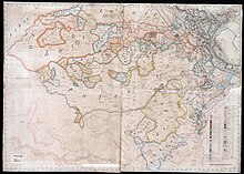
Map created by the British East India Company of the Malwa region of Punjab showing the various polities, borders, and settlements of the area, ca.1829–1835. Rupnagar, Moga, Jagraon, Dharamkot, Kotkupura, Muktsar, and Sahnewal, are marked as the territories south of the Sutlej River which were controlled by the Sikh Empire.
The city of Ferozepur, located in the Malwa region, was founded sometime in the latter half of the 14th century by Firuz Shah Tughlaq the third of the Delhi Sultanate.[6] Later-on during the Mughal Empire, Ferozepur acted as the capital of the Multan subah (province) according to the Ain-i-Akbari.[6][7] With the shifting course of the Sutlej River, the region fell into decline, as the river which formerly provided a means of sustenance and fertility to the land became destructive and transformed the landscape of Malwa into mounds and deserts.[7] Malwa had essentially taken on the appearance of a desert by the early 16th century due to these natural circumstances.[7]
By the end of the 16th century, there was a migration of various Jat clans into the region for settlement, namely the Bhatti, Dhaliwal, Gill, and Sidhu clans, who entered the region from the south and southeast.[7] The Sidhu clan of the Jats wielded power and influence in the local area.[6][8] According to Pashaura Singh, the unpredictable power of the Sutlej River led to the toughening of the character of these newcomers.[7]
Sikh period
The first Sikh guru to tour the Malwa region was Guru Hargobind, the sixth guru of the Sikhs.[7] Prior to Hargobind, no Sikh guru had toured the region, which is in-contrast to the neighbouring Majha and Doaba regions, which were introduced to Sikhism earlier-on, as per Dalbir Singh Dhillon.[7] Thus, most of the Jat tribes of Malwa were converted to Sikhism during the course of the 17th century.[7] With Guru Hargobind taking refuge in the forests of Daroli (present-day Daroli Bhai in Moga district) located in Malwa, many youths were drawn to the new religion and were martialized within this context.[7] Guru Hargobind was physically impressive in stature and charismatic with his missionary efforts, which drew-in converts in the region and providing new recruits for his Akal Sena.[7] While at Daroli, Guru Hargobind kept in close communication with Bhai Gurdas and Baba Buddha.[7] After the execution of Guru Arjan, the central Sikh headquarters at Amritsar came under close Mughal surveillance, which led to the development of Daroli in Malwa as a "itinerant Sikh centre" during the guruship of Guru Hargobind.[7]Baba Gurditta, the son of Guru Hargobind and Mata Damodari, and father of Guru Tegh Bahadur, was born in the forests of Daroli in 1608.[9]
Guru Hargobind visited the Jagraon region of Malwa in western Ludhiana and a Gurdwara called 'Guru Sar' was constructed in the village of Kaunke, located 7 km southwest of the city of Jagraon itself, to commemorate his visit to the locality between the years 1631–1632.[10] During the early Mughal-Sikh wars, in 1634 Guru Hargobind left Amritsar to avoid Mughal persecution and arrived near Moga with fresh recruits enlisted en-route to stage a counter-attack against the Mughal government.[11] When near Moga, he sent his family to safety in Kartarpur and whilst he remained in the Malwa region with his army.[11]
At Dagru village in Moga district, it is believed Guru Har Rai stayed there for some time whilst on a tour of the Malwa region.[12] Gurdwara Tambu Sahib was later constructed to commemorate his stay in the area.[12]
The tenth guru of the Sikhs, Guru Gobind Singh, traveled around the Muktsar part of the Malwa region for around a year, converting many local Jats to Sikhism while doing so.[13] During the Sikh Confederacy of the 18th century, the Bhangi Misl held sway.[6]
Culture
Equestrian painting of a Sikh from Malwa, Company School, Punjab Plains, ca.1840
1 2 3 Grover, Parminder Singh; Singh, Davinderjit (2011). "Section 1: Introduction – Regions of Punjab". Discover Punjab: Attractions of Punjab. Photographs by Bhupinder Singh. Ludhiana, Punjab, India: Golden Point Pvt Lmt. Regions of Punjab: The much-truncated India's portion of present Punjab is divided into three natural regions: The Maiha, The Doaba, The Malwa. Majha: Majha starts northward from the right bank of river Beas and stretches up to the Wagha village, which marks the boundary between India and Pakistan. Majha in Punjabi means the heartland. The region is divided into three districts: 1. Amritsar, 2. Gurdaspur, 3. Tarn Taran. Doaba: The rivers Sutlei in the south and Beas in the North bound the Doaba of Puniab. The Doaba region is divided into four districts: 1. Jalandhar, 2. Nawanshahr, 3. Kapurthala, 4. Hoshiarpur. Malwa: The area south of the river Sutlej is called Malwa. The name has stuck because a clan called Molois (sometimes written as Malawis in ancient works) once ruled this area, which must have spread up to present State of Gujrat which was known as the Subah of Malwa as late as the Mughul times. Malwa the largest part of the Punjab is divided into the following 12 districts after the names of their headquarters: 1. Bathinda, 2. Barnala, 3. Faridkot, 4. Fatehgarh Sahib, 5. Ferozepur, 6. Ludhiana, 7. Mansa, 8. Moga, 9. Sangrur, 10. Muktsar, 11. Patiala, 12. Rup Nagar, 13. SAS Nagar - Mohali.
1 2 Singh, Mandeep (2005). Punjab Today. Harvinder Kaur. New Delhi: Deep & Deep Publications. p.11. ISBN81-7629-702-X. OCLC62536488. The people of the region speak the Malwa dialect, which is similar to Punjabi. Malwa is surrounded by the river Sutlej in the north, the river Ghaggar in the south, the Shivalik Hills in the east and Pakistan in the west.
1 2 3 4 5 6 7 Bassi, Tripti (2021). A Study of the Sikh Kanya Mahavidyalaya: Education, Religion and Gender Issues. Singapore: Springer Nature. p.42. ISBN978-981-16-3219-8. OCLC1259627824. Historically, the city was founded by Firoz Shah Tughlaq III (1351-1388 A.D). It was earlier an important centre between Delhi and Lahore (Sharma, 1983: 17). Firoz Shah III constructed the Ferozepore fort around 1370 (GoP, 2000: 13). The Ain-i-Akbari also refers to 'Ferozepore' as the capital of Multan province. After a series of successions by Sidhu Jatts and the Bhangi Misl, the district became 'the advanced outpost of British India in the direction of the Sikh power' in 1839 (Imperial Gazetteer of India, 1908a, b: 440-441). Finally, in 1846, it formally became part of the British Empire. ... Ferozepur is southwest of 'Malwa region of Punjab. On the basis of culture, Punjab is distinguished into three areas- Majha, Doaba and Malwa. Rivers mark these folk regions with unique physical milieu, economic organization and cultural practices. Majha is in upper Bari Doab comprising districts of Amritsar and Gurdaspur. Doaba or Bist. Doaba comprises districts of Hoshiarpur, Nawanshahar, Kapurthala and certain sections of Fazilka. Malwa region is south of river Sutlej. It includes eleven districts of Punjab and so is the largest region of Punjab. In contrast to Majha and Doaba, Malwa is thinly populated and is bound by rivers Sutlej in the North, Ghaggar in the south, Shivalik hills in the east and Pakistan in the west (GoP, 2004: 26-29).
1 2 3 4 5 6 7 8 9 10 11 12 Singh, Pashaura (9 August 2024). The Routledge Companion to the Life and Legacy of Guru Hargobind: Sovereignty, Militancy, and Empowerment of the Sikh Panth. Taylor & Francis. pp.98–99. ISBN9781040106327.
↑ Singh, Pashaura (9 August 2024). The Routledge Companion to the Life and Legacy of Guru Hargobind: Sovereignty, Militancy, and Empowerment of the Sikh Panth. Taylor & Francis. p.100. ISBN9781040106327.
↑ Singh, Harbans (2011). The Encyclopaedia of Sikhism (3rded.). Patiala: Punjabi University. p.426. ISBN978-81-7380-204-1.
1 2 Singha, H.S. (2000). The Encyclopedia of Sikhism (Over 1000 Entries). Hemkunt Press. p.194. ISBN9788170103011. 1. Tambu Sahib, Dagru: It is situated in village Dagru near Moga and is dedicated to Guru Har Rai who encamped here in the course of his journey through the Malwa region.
↑ Dhillon, Harish (2015). The Sikh Gurus. Hay House Publishing. ISBN978-93-84544-45-4. OCLC968092357. The Guru spent a year travelling around Muktsar. This region is the Malwa region and the inhabitants are mostly Jats - simple, hardworking and straight-forward people, people who revel in the freedom of both of thought and action. They found the Guru's teachings to be simple and practical and that they gave freedom to people who had been bound for centuries by caste and by ceremonies and rituals. As a result many of the people from this region joined this new faith.
↑ Duggal, Kartar Singh (1988). Philosophy and Faith of Sikhism. Honesdale, Pa.: Himalayan International Institute of Yoga Science and Philosophy of the U.S.A. p.77. ISBN0-89389-109-6. OCLC21934816. According to the renowned Sikh Scholar, the late Principal Teja Singh, Punjabi is the language that the people of the Punjab have spoken from time immemorial. A living language keeps on changing its complexion. During the course of history, this change in complexion may result in the language being transformed beyond recognition. Punjabi has undergone this metamorphosis time and again and yet it remains Punjabi, the language to which the people in this part of the country belong. Even today the language spoken by the people living in Pothoar is different in flavor from the one spoken in Malwa, as much as the language spoken in Malwa is different in taste from that of Majha. It is said that the dialects in India start changing about every 30 kilometers. Like all other Indian languages, Punjabi, too, has a number of dialects. They can be as diverse as Pahari, spoken in the north, and Lehndi, prevalent in the south.
↑ Singh, Nahar; Gill, R.S. (2004). "Folk Practices in Punjab"(PDF). Journal of Punjab Studies. 11 (2): 171–196. Retrieved 29 March 2023.
This page is based on this Wikipedia article Text is available under the CC BY-SA 4.0 license; additional terms may apply. Images, videos and audio are available under their respective licenses.