Nilgiri Mountains | |
---|---|
Highest point | |
Peak | Doddabetta, Tamil Nadu |
Elevation | 2,637 m (8,652 ft) |
Listing | Ultra List of Indian states and territories by highest point |
Coordinates | 11°22′30″N76°45′30″E / 11.375°N 76.75833°E |
Naming | |
English translation | Blue Mountains in Tamil |
Geography | |
Location | Tamil Nadu, Kerala, Karnataka |
Parent range | Western Ghats Eastern Ghats |
Geology | |
Age of rock | Archean Eon, 3000 to 500 mya |
Mountain type | Fault [1] |
Climbing | |
Easiest route | NH 67 or Nilgiri Mountain Railway |
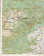
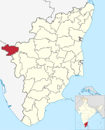
The Nilgiri Mountains form a part of the Western Ghats in northwestern Tamil Nadu, southern Karnataka and eastern Kerala in South India. They are located at the trijunction of the three states and connect the Western Ghats to the Eastern Ghats. At least 24 of the Nilgiri Mountains' peaks are above 2,000 m (6,600 ft), with the highest peak being Doddabetta at 2,637 m (8,652 ft).
The word Nilgiri, comes from Tamil words neelam (blue) + giri (mountain), has been in use since at least 1117 CE. In Tamil literature it is mentioned as Iraniyamuttam [2] [3] It is thought that the bluish flowers of kurinji shrubs gave rise to the name. [4]
The Nilgiri Hills are separated from the Karnataka Plateau to the north by the Moyar River. [5]
Three national parks border portions of the Nilgiri mountains. Mudumalai National Park lies in the northern part of the range where Kerala, Karnataka, and Tamil Nadu meet, covering an area of 321 km2 (124 sq mi). Mukurthi National Park lies in the southwest part of the range, in Kerala, covering an area of 78.5 km2 (30.3 sq mi), which includes intact shola-grassland mosaic, habitat for the Nilgiri tahr. Silent Valley National Park lies just to the south and contiguous with those two parks, covering an area of 89.52 km2 (34.56 sq mi).[ citation needed ]
The high steppes of the Nilgiri Hills have been inhabited since prehistoric times, demonstrated by a large number of artifacts unearthed by excavators. A particularly important collection from the region can be seen in the British Museum, including those assembled by colonial officers James Wilkinson Breeks, Major M. J. Walhouse and Sir Walter Elliot. [6]
The first recorded use of the word Nila applied to this region can be traced back to 1117 CE. In the report of a general of Vishnuvardhana, King of Hoysalas, who in reference to his enemies, claimed to have "frightened the Thodas, driven the Kongas underground, slaughtered the Poluvas, put to death the Maleyalas, terrified Chieftain Kala Nirpala and then proceeded to offer the peak of Nila Mountain.(presumably Doddabetta or Rangaswami peak of Peranganad in East Nilgiris) to Lakshmi, Goddess of Wealth. Neelagiri was ruled by Baduga King Kala Raja before 1117 CE." [7]
A hero stone (Veeragallu) with a Kannada inscription at Vazhaithottam (Bale thota) in the Nilgiri District, dated to 10th century CE, has been discovered. [8] A Kannada inscription of Hoysala king Ballala III (or his subordinate Madhava Dannayaka's son) from the 14th century CE has been discovered at the Siva (or Vishnu) temple at Nilagiri Sadarana Kote (present-day Dannayakana Kote), near the junction of Moyar and Bhavani rivers, but the temple has since been submerged by the Bhavani Sagar dam. [8] [9]
In 1814, as part of the Great Trigonometrical Survey, a sub-assistant named Keys and an apprentice named McMahon ascended the hills by the Danaynkeucottah (Dannayakana Kote) Pass, penetrated into the remotest parts, made plans, and sent in reports of their discoveries. As a result of these accounts, Messrs. Whish and Kindersley, two young Madras civilians, ventured up in pursuit of some criminals taking refuge in the mountains, and proceeded to observe the interior. They soon saw and felt enough favorable climate and terrain to excite their own curiosity, and that of others. [10]
After the early 1820s, the hills were developed rapidly under the British Raj, because most of the land was already privately owned by British citizens. It was a popular summer and weekend getaway for the British during the colonial days. In 1827, Ooty became the official sanatorium and the summer capital of the Madras Presidency. Many winding hill roads were built. In 1899, the Nilgiri Mountain Railway was completed by influential and enterprising British citizens, with venture capital from the Madras government. [11] [12]
In the 19th century, when the British Straits Settlement shipped Chinese convicts to be jailed in India, the Chinese men settled in the Nilgiri mountains near Naduvattam after their release and married Tamil Paraiyan women, having mixed Chinese-Tamil children with them. They were documented by Edgar Thurston. [13]
The highest point in the Nilgiris and the southern extent of the range is Doddabetta Peak (2,637 metres (8,652 ft)), [14] 4 km east southeast of Udhagamandalam, 11°24′10″N76°44′14″E / 11.40278°N 76.73722°E .
Closely linked peaks in the west of Doddabetta range and nearby Udhagamandalam include:[ citation needed ]
Snowdon (height: (2,530 metres (8,301 ft)) 11°26′N76°46′E / 11.433°N 76.767°E is the northern extent of the range. Club Hill (2,448 metres (8,031 ft)) and Elk Hill (2,466 metres (8,091 ft)) 11°23′55″N76°42′39″E / 11.39861°N 76.71083°E are significant elevations in this range. Snowdon, Club Hill and Elk Hill with Doddabetta, form the impressive Udhagamandalam Valley.
Devashola (height: 2,261 metres (7,418 ft)), notable for its blue gum trees, is in the south of Doddabetta range.
Kulakombai (1,707 metres (5,600 ft)) is east of the Devashola. The Bhavani Valley and the Lambton's peak range of Coimbatore district stretch from here.
Muttunadu Betta (height: 2,323 metres (7,621 ft)) 11°27′N76°43′E / 11.450°N 76.717°E is about 5 km, north northwest of Udhagamandalam. Tamrabetta (Coppery Hill) (height: 2,120 metres (6,955 ft)) 11°22′N76°48′E / 11.367°N 76.800°E is about 8 km southeast of Udhagamandalam. Vellangiri (Silvery Hill) (2,120 metres (6,955 ft)) is 16 km west-northwest of Udhagamandalam. [15]
The highest waterfall, Kullakamby Fall, north of Kolakambai hill, has an unbroken fall of 400 ft (120 m). Nearby is the 150 ft (46 m) Halashana falls. The second highest is Catherine Falls, near Kotagiri, with a 250 ft (76 m) fall, named after the wife of M.D. Cockburn, believed to have introduced coffee plantations to the Nilgiri Hills. The Upper and Lower Pykara falls have falls of 180 ft (55 m), and 200 ft (61 m), respectively. The 170 ft (52 m) Kalhatti Falls is off the Segur Peak. The Karteri Fall, near Aruvankadu had the first power station which supplied the original Cordite Factory with electricity. Law's Fall, near Coonoor, is interesting due to its association with the engineer Major G. C. Law who supervised building of the Coonoor Ghat road. [16]
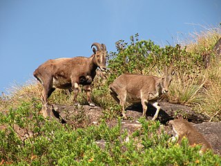
Over 2,800 species of flowering plants, 160 species of fern and fern allies, countless types of flowerless plants, mosses, fungi, algae, and land lichens are found in the sholas of the Nilgiris. No other hill station has as many species. [17] It is also home to mammals like the Bengal tiger, Indian elephant, Indian leopard, chital deer, gaur, sambar deer, dhole, golden jackal, Indian boar, Nilgiri tahr, Indian spotted chevrotain, black buck, Asian palm civet, sloth bear, four-horned antelope, Nilgiri marten, Indian crested porcupine, Malabar giant squirrel, honey badger, Indian grey mongoose, Indian pangolin, Indian fox, smooth coated otter, and painted bat. The Indian python, king cobra, common krait, Indian cobra, Malabar pit viper, Nilgiri keelback, Oriental garden lizard, Eryx whitakeri and mugger crocodile are reptiles found here. Primates include the lion tailed macaque, Nilgiri langur, gray langur and bonnet macaque. The birds found here are Indian peacock, Nilgiri laughing thrush, Nilgiri flycatcher, grey junglefowl, Malabar pied hornbill, Malabar parakeet, great hornbill, Nilgiri wood pigeon, Indian vulture, black-hooded oriole, grey-headed bulbul and Malabar grey hornbill. Amphibians on the list are the purple frog, Silent valley brush frog, Malabar gliding frog, Beddomixalus and many more. It is the only place in South India to have the white tiger.
The dominant type of habitat is tropical rainforest. Montane forests and tropical moist forests are also found here. Much of the forest habitats have been much disturbed or destroyed by extensive tea plantations, easy motor-vehicle access, extensive commercial planting and harvesting of non-native eucalyptus and wattle ( Acacia dealbata , Acacia mearnsii ) plantations, and cattle grazing. [18] The area also features one large and several smaller hydro-electric impoundments. [19] Scotch broom has become an ecologically damaging invasive species. [20]
Threatened plants of the Nilgiris include:
Ooty, abbreviated as Udagai) is a town and municipality in the Nilgiris district of the Indian state of Tamil Nadu. It is located 86 km (53 mi) northwest of Coimbatore, and is the headquarters of Nilgiris district. Situated in the Nilgiri hills, it is known by the epithet "Queen of Hill Stations", and is a popular tourist destination.
The Nilgiris district is one of the 38 districts in the southern Indian state of Tamil Nadu. Nilgiri is the name given to a range of mountains spread across the borders among the states of Tamil Nadu, Karnataka and Kerala. The Nilgiri Hills are part of a larger mountain chain known as the Western Ghats. Their highest point is the mountain of Doddabetta, height 2,637 m. The district is contained mainly within the Nilgiri Mountains range. The administrative headquarters is located at Ooty. The district is bounded by Coimbatore to the south, Erode to the east, and Chamarajnagar district of Karnataka and Wayanad district of Kerala to the north. As it is located at the junction of three states, namely, Tamil Nadu, Kerala, and Karnataka, significant Malayali and Kannadiga populations reside in the district. Nilgiris district is known for natural mines of Gold, which is also seen in the other parts of Nilgiri Biosphere Reserve extended in the neighbouring states of Karnataka and Kerala too.
Coonoor, is a taluk and a municipal town of the Nilgiris district in the Indian state of Tamil Nadu. As of 2011, the town had a population of 45,494. The town sits at the south-east corner of the Nilgiri plateau, and at the head of the Coonoor Ghat, the principal pass connecting the Nilgiris to the plains. It is 363 miles by rail from Chennai and 12 miles from Ooty. The town is built within the picturesque Jackatalla valley (Jagathala), surrounded by wooded hills.
The Nilgiri Mountain Railway (NMR), colloquially called the "Toy Train" by locals is a 1,000 mmmetre gauge railway in Nilgiris district, Tamil Nadu, India, built by the British in 1908. The railway is operated by the Southern Railway and is the only rack railway in India.
Doddabetta is the highest mountain in the Nilgiri Mountains at 2,637 metres (8,652 ft). There is a reserved forest area around the peak. It is 9 km from Ooty, on the Ooty-Kotagiri Road in the Nilgiris District of Tamil Nadu, India. It is a popular tourist attraction with road access to the summit. It is the third highest peak in South India next to Anamudi and Meesapulimala. The peaks Hecuba, Kattadadu and Kulkudi are the three closely linked summits in the west of the Doddabetta range near to Udagamandalam. The word Doddabetta is derived from Kannada, meaning 'big hill'.
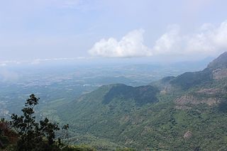
The Cardamom Hills or Yela Mala are mountain range of southern India and part of the southern Western Ghats located in Idukki district, Kerala, India. Their name comes from the cardamom spice grown in much of the hills' cool elevation, which also supports pepper and coffee. The Western Ghats and Periyar Sub-Cluster including the Cardamom Hills are UNESCO World Heritage Sites.
The Nilgiri Biosphere Reserve is a biosphere reserve in the Nilgiri Mountains of the Western Ghats in South India. It is the largest protected forest area in India, spreading across Tamil Nadu, Karnataka and Kerala. It includes the protected areas Mudumalai National Park, Mukurthi National Park, Sathyamangalam Wildlife Sanctuary in Tamil Nadu; Nagarhole National Park, Bandipur National Park, both in Karnataka; Silent Valley National Park, Aralam Wildlife Sanctuary, Wayanad Wildlife Sanctuary, and Karimpuzha Wildlife Sanctuary in Kerala.
Mukurthi National Park (MNP) is a 78.46 km2 (30.3 sq mi) protected area located in the western corner of the Nilgiris Plateau west of Ootacamund hill station in the northwest corner of Tamil Nadu state in the Western Ghats mountain range of South India. The park was created to protect its keystone species, the Nilgiri tahr.
Mettupalayam is a municipal town and headquarters of Mettupalayam Taluk in the Coimbatore district of the Indian state of Tamil Nadu. It is the second largest town in the Coimbatore district after Pollachi. It is located to the north of Coimbatore city on the way to Ooty, in the foothills of Nilgiri hills. As of 2011, the town had a population of 69,213. Mettupalayam railway station is the starting point of Nilgiri Mountain Railway and it operates the only rack railway in India connecting Ooty and Mettupalayam.
Sispara, സിസ്പാര, a proper noun, is a combination of the Badaga language words si:su + pore; meaning: magnetite bearing rock + gorge. It may refer to:
The Grizzled Squirrel Wildlife Sanctuary (GSWS), also known as Srivilliputhur Wildlife Sanctuary, was established in 1988 to protect the Near threatened grizzled giant squirrel. Occupying an area of 485.2 km2, it is bordered on the southwest by the Periyar Tiger Reserve and is one of the best preserved forests south of the Palghat Gap.
Mukurthi Peak is one of the highest peaks in the Western Ghats, situated on the border of Udagamandalam taluk, Nilgiris, Tamil Nadu, Nilambur taluk, Malappuram, and Kerala in India. It reaches an altitude of 2,554 m (8,379ft), and is the fifth-highest peak in South India.
The Pothigai Hills, also known as Agasthiyar Mountain is a 1,866-metre (6,122 ft)-tall peak in the southern part of the Western Ghats or Sahyadri of South India. The peak lies in Tirunelveli District of Tamil Nadu near the border of Kerala.
New Amarambalam reserved forest is a reserved forest in the Western Ghats, situated in the Malappuram District of Kerala state of India. It extends till Silent Valley National Park of the Palakkad District to the south and to Nadugani in the Nilgiri District of Tamil Nadu to the North. It is under the Karimpuzha Wildlife Sanctuary.
Sigur Plateau is a plateau in the north and east of Nilgiri District in the Nilgiri Hills of Tamil Nadu, South India. It covers the 778.8 square kilometres (300.7 sq mi) portion of the Moyar River drainage basin on the northern slopes of the Nilgiri Hills, south of the Moyar River.
Kalhatti Falls also called as Bird Watcher's Falls is a tourist spot near Ooty, The Nilgiris, Tamil Nadu. These falls are about 13 km (8.1 mi) from Ooty, on the Ooty to Mysore Road or Sigur Ghat Road, It is situated at an elevation of about 1,600 m (5,200 ft) in the Sigur Plateau. This place is rich in bird life. Wild animals such as deer, wild buffalo and sambhar come to drink water. From Kalhatti village the falls can be reached by trekking for 3 km (1.9 mi).
Mettupalayam railway station is an NSG–4 category Indian railway station in Salem railway division of Southern Railway zone. It is a railway station located in Mettupalayam, a suburb of Coimbatore district in the Indian state Tamil Nadu. It is one of the important railway stations located in the Coimbatore District, because the Nilgiri Mountain Railway to the hill station of Ooty starts from here. It is the connection between the metre-gauge Nilgiri Mountain Railway and the broad-gauge main network of Indian Railways. It recently celebrated its 150th anniversary.
Halatty Manthalatty is a village in the Indian state of Tamil Nadu, under the Nilgiris District. Halatty Manthalatty is also the name given to a range of mountains spread across the states of Tamil Nadu as well as Karnataka and Kerala. It is one of the small villages in Udhagamandalam Taluk in The Nilgiris District under Kadanad Panchayat. Around 100 families and Around 400 people are living in this village.
Mysore-Ooty Road or Mysore-Udhagamandalam Road is a tourist trail of South India starting from Mysore in Karnataka state and ending in Udhagamandalam in Nilgiri district of Tamil Nadu state, India. Both routes pass through Bandipur National park in Gundlupet, Karnataka and Mudumalai National Park in Tamil Nadu.
Kolaribetta is the second highest peak in the Nilgiri hills of the Western Ghats, located in Tamil Nadu, India.
{{cite book}}
: |work=
ignored (help)d: Tamil-Chinese Crosses in the Nilgiris, Madras. S. S. Sarkar* (Received on 21 September 1959) During May 1959, while working on the blood groups of the Kotas of the Nilgiri Hills in the village of Kokal in Gudalur, inquiries were made regarding the present position of the Tamil-Chinese cross described by Thurston (1909). It may be recalled here that Thurston reported the above cross resulting from the union of some Chinese convicts, deported from the Straits Settlement, and local Tamil Paraiyan