Bhadra dam | |
---|---|
Official name | Bhadra |
Location | Bhadravathi and Tarikere border |
Coordinates | 13°42′0″N75°38′24″E / 13.70000°N 75.64000°E |
Construction cost | Rs.520 crores |
Operator(s) | Water Resources Department and Karnataka Power Corporation Limited |
Dam and spillways | |
Impounds | Bhadra River, a tributary of Tungabhadra River |
Height | 59.13 metres (194.0 ft) |
Length | 1,708 metres (5,604 ft) |
Reservoir | |
Creates | Multipurpose |
Total capacity | 71.50 billion cubic feet |
Catchment area | 1,968 km2 (760 sq mi) |
Surface area | 11,250.88 hectares (27,801.5 acres)hectares |
[1] [2] |
The Bhadra Dam or Lakkavalli Dam, which has created the Bhadra Reservoir, is located on the Bhadra River a tributary of Tungabhadra River. Bhadra Dam is located in the border of Bhadravathi and Tarikere, in the western part of Karnataka in India. The benefits derived from the reservoir storage are irrigation with gross irrigation potential of 162,818 hectares (402,330 acres), [1] hydro power generation of 39.2 MW (three powerhouses, located on the right and left bank main canals [3] [4] ), drinking water supply and industrial use. The dam commissioned in 1965 is a composite earth cum masonry structure of 59.13 metres (194.0 ft) height with length of 1,708 metres (5,604 ft) at the crest level, which submerges a land area of 11,250.88 hectares (27,801.5 acres). [1] [5]
The Bhadra River rises at Samse in the Western Ghats Aroli hill range of Kudremukh range, Chikkamagaluru district and flows east across the Deccan Plateau. It is joined by its tributaries, the Somavahini (drains from a crater and meets Bhadra River at Hebbe), Thadabehalla, and Odirayanahalla.The more than 90% of the catchment area lies in Chikkamagaluru District. The river flows through the city of Bhadravathi and the Bhadra Wildlife Sanctuary. The Bhadra meets the Tunga River at Koodli, a small town near Shivamogga. The combined river continues east as the Tungabhadra, a major tributary of the Krishna, which empties into the Bay of Bengal. The Bhadra Dam is built across the Bhadra River in Lakkavalli- Tarikere Taluk. Lies 0.5 kilometres (0.31 mi) from Singanamane village (Bhadravathi taluk), 1.5 kilometres (0.93 mi) from Lakkavalli village (Tarikere taluk) and 50 kilometres (31 mi) upstream of the confluence of the Bhadra River and Tungabhadra River. [6] Shimoga city is located 28 kilometres (17 mi) north of the dam. [7] The Bhadra Dam drains a catchment area of 1,968 square kilometres (760 sq mi) out of which the forest area is 717.49 hectares (1,773.0 acres), cultivable land is 3,274.65 hectares (8,091.8 acres) and fallow land is 7,258.74 hectares (17,936.7 acres). [1] [2] [6] A number of industries, urban and rural settlements dependent on assured water supply lie on the banks of the river and in the project command area; Kudremukh Iron Ore Company Ltd, the Mysore Paper Mills and Vishweshvarayya Iron and Steel Industries are the major industrial activity noted in the command area of the project.
The Bhadra River basin receives an average annual rainfall of 2320 mm with rainfall occurring during monsoon period (June to November). [3] The rainfall is experienced both during the Southwest Monsoon and North East monsoon; inflow contribution is 82% from SW monsoon (June to September) and 18% from north-eastern monsoon (October to December). The annual yield assessed from a catchment area of 1,968 square kilometres (760 sq mi) at the dam site is 84.63 BCF (billion cubic feet) in a 75% dependable year. [1] [3] [6] Based on recordings taken over a period of 25 years, it has an estimated annual mean evapotranspiration of 1,678 mm. [8]
The Bhadra Dam project was the irrigation scheme to be undertaken by the National Water Management Project (NWMP), with the aim of increasing agricultural prosperity, particularly for rice production. [8] The dam was built to a height of 59.13 metres (194.0 ft) (above the river bed level) between 1947 (start of construction) and 1965 (year of commissioning). It has a gross storage capacity of 2.025 km3, [5] live storage of 63.00 BCF at full reservoir level and a dead storage of 8.50 BCF at RL (reservoir level) of 631.54 metres (2,072.0 ft). [1] [5] The storage created by the reservoir is according to the allocation of 61.70 BCF (1.747 km3 including direct evaporation of 0.14 km3) of water made under the Krishna Water Disputes Tribunal Award. [5] The dam is built on a shattered rock based with a central masonry spillway. It has an earthen embankment on the left side and a rock hillock on the opposite side. [9] The Ogee type spillway in the middle section of the river has been provided with four numbers of vertical lift gates over a width of 18.28 metres (60.0 ft) and designed for a discharge of 3,020 cubic metres (107,000 cu ft)/s. In addition, two number river sluices are also provided to pass a discharge of 13,300 cubic metres (470,000 cu ft)/s. The annual siltation load considered in the design is 10.78 million cubic feet per square kilometer of catchment area. The canal outlets provided in the dam, initially for Hydropower generation followed by irrigation, consists of the left Bank canal outlet to discharge 10.76 cubic metres (380 cu ft)/s and two right bank canal outlets to pass a discharge of 75.03 cubic metres (2,650 cu ft)/s. [1] [5] [6] There are several islands in the reservoir area which have been developed for tourism. [7]
The dam has four spillway gates. The gate type is not exactly pronounced as either Ogee or Radial. This dam falls under the Parliamentary Constituency of Udupi Chikmagalur. The dam is classified as Earthen/ Gravity & Masonry. [10]
The reservoir created by the dam submerged 27 villages. [1]
The Left Bank Canal is designed to carry a discharge of 10.76 cubic metres (380 cu ft)/s, starting from the tail race of the left bank powerhouse provides irrigation facilities over its total length of 77 kilometres (48 mi). [1] The Right Bank canal, originating from the tail race channel of the right bank powerhouse provides irrigation facilities through its length of the main canal of 103 kilometres (64 mi) designed to carry a discharge of 75.03 cubic metres (2,650 cu ft)/s and its branch canal system of 284.9 kilometres (177.0 mi). Gross command area from the project is 162,818 hectares (402,330 acres), cultivable command is 121,500 hectares (300,000 acres) and irrigated command and cropped area is 105,570 hectares (260,900 acres). The soils encountered in the Right Bank Canal irrigation command consisted of Black Cotton Soils 8.5% and Red soil 93.5%, while on the Left Bank Canal command it comprises Black Cotton Soils 7.0% and Red soil 93%. [1]
The irrigation component of the project was planned to provide an annual cropping intensity of 200 percent to irrigate semi-dry crops in nearly 60 percent of the command area dominated by red loamy soils. [6] Irrigated area spreads over Davanagere, Shivamogga, Chikmagalur and Bellary districts comprising predominantly red loamy soils except in some portions of the right bank canal area which consist of Black Cotton soils. However, the actual cropping was predominately rice and also sugarcane and permanent gardens; [3] 90% area on the left bank canal system and 60% area of the right bank canal system was dominated by rice. This practice resulted in heavy demand on water causing serious concerns on the irrigation system itself. Consequently, National Water Management Project (NWMP) was launched with the objective to "rehabilitate and provide more equitable, predictable and reliable irrigation service which could improve agricultural productivity and farm income". This project has resulted in substantial improvements in both the area brought under irrigation and consequent agricultural crop production. [6]
The water stored in the reservoir is diverted through the right and left bank power houses into the respective irrigation canal systems. The right bank powerhouse utilises the irrigation releases for power generation from two units of Kaplan-type turbine generators and one unit of 6MW capacity. The left bank powerhouse at the river bed utilizes the irrigation releases to generate power from two units of 12 MW capacity each and another power house on the left bank canal of one unit of 2 MW capacity. The three power stations together have a power generation capacity of 39.2 MW. [3] [4]
The Bhadra River flows through the Bhadra Tiger Reserve and Wildlife Sanctuary and the Bhadra Reservoir is on its northern border. The sanctuary has rich avifauna such as junglefowl, red spurfowl, painted bush-quail, emerald dove, southern green imperial pigeon, great black woodpecker, Malabar parakeet and hill myna. Reptiles reported in the river and the reservoir are the marsh crocodiles and monitor lizards. Common river otter and smooth Indian otters, gaurs and leopards are commonly sighted in the reserve. The wildlife can be viewed by taking a boat ride in the reservoir when Tyavarekoppa Lion and Tiger Safari and the Sakkrebyle Elephant Camp can also be visited. [11] [12]
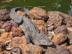
Marsh crocodiles are found all along the Bhadra River and more so after the river enters the sanctuary area and further flows through midst of the undisturbed moist deciduous forests till it joins the back waters of the reservoir of the Bhadra Dam. [13]
The Daman Ganga formerly called the Sandalcalo River is a river in western India. The river's headwaters are on the western slope of the Western Ghats range, and it flows west into the Arabian Sea. The river flows through Maharashtra and Gujarat states, as well as the Union territory of Dadra and Nagar Haveli and Daman and Diu. The industrial towns of Vapi, Dadra and Silvassa lie on the north bank of the river, and the town of Daman occupies both banks of the river's mouth.
Pothundi Dam is an irrigation dam near Pothundi village in the Palakkad district of Kerala state, India. Constructed in the 19th century, it is considered one of the oldest dams in India. It provides irrigation to an area of 5,470 hectares in the Palakkad district and drinking water supply to the Nemmara, Ayalur, Melarcode Panchayat. An unusual feature of the earth dam is the core wall, which is built with a mixture of jaggery and quick lime.
The Gandhi Sagar Dam is one of the four major dams built on India's Chambal River. The dam is located in the Mandsaur district of the state of Madhya Pradesh. It is a masonry gravity dam, standing 62.17 metres (204.0 ft) high, with a gross storage capacity of 7.322 billion cubic metres from a catchment area of 22,584 km2 (8,720 sq mi). The dam's foundation stone was laid by Prime Minister of India Pandit Jawaharlal Nehru on 7 March 1954, and construction of the main dam was done by leading contractor Dwarka Das Agrawal & Associates and was completed in 1960. Additional dam structures were completed downstream in the 1970s.
Nagarjuna Sagar Dam is a masonry dam across the Krishna River at Nagarjuna Sagar which straddles the border between Palnadu district in Andhra Pradesh and Nalgonda district in Telangana. The dam provides irrigation water to the districts of Krishna, Guntur, Palnadu, Prakasam and parts of West Godavari districts of Andhra Pradesh and also combined Nalgonda, Khammam districts of Telangana. It is also a source of electricity generation for the national grid.
Bhadra Wildlife Sanctuary is a protected area and tiger reserve as part of the Project Tiger, situated in Chikkamagaluru district, 23 km (14 mi) south of Bhadravathi city, 38 km (24 mi) 20 km from Tarikere town, northwest of Chikkamagaluru and 283 km from Bengaluru city in Karnataka state, India. Bhadra sanctuary has a wide range of flora and fauna and is a popular place for day outings. The 1,875 m (6,152 ft) above MSL Hebbe Giri is the highest peak in the sanctuary.
Split Rock Dam is a minor ungated concrete faced rock fill embankment dam with concrete chute spillway across the Manilla River upstream of Manilla in the north-western slopes region of New South Wales, Australia. The dam's purpose includes flood mitigation, irrigation, water supply and conservation. The impounded reservoir is called Split Rock Reservoir.
Shihmen Dam is a major rock fill dam across the Dahan River in northern Taoyuan City. It forms the Shihmen Reservoir (石門水庫), Taiwan's third largest reservoir or artificial lake. It provides irrigation in Taoyuan, flood control for the Taipei Basin, and hydroelectricity and domestic water supply for more than three million people in northern Taiwan.
The Kankai River is a trans-boundary river flowing through the hills of Ilam and the plains of the Jhapa District in Nepal. It begins at the confluence of the Mai Khola and Deb Mai Khola rivers.
The Upper Wardha Dam is an earthfill straight gravity dam across the Wardha River, a tributary of the Godavari River, near Simbhora village in Morshi taluk in Amravati district in the Indian state of Maharashtra. The dam provides multipurpose benefits of irrigation, drinking water supply, flood control and hydropower generation.
Idamalayar Dam is a multipurpose concrete gravity dam located at Ennakkal between Ayyampuzha and Bhoothathankettu in Ernakulam district of Kerala on the Idamalayar, a tributary of the Periyar River in Kerala, South India. The dam however extends east as far as Malakkappara. Completed in 1985, with a length of 373 metres (1,224 ft) and a height of 102.8 metres (337 ft), the dam created a multipurpose reservoir covering 28.3 km2 (10.9 sq mi) in the scenic hills of the Anamalais.
Chinit River is a river of Cambodia. Located in Kampong Thom Province, it is a major tributary of the Tonlé Sap Lake, which joins the Tonlé Sap River at the downstream end in the larger Mekong basin. Somewhat unusually the river is looped back into the same river system, which accounts for its length of 264 kilometres (164 mi), leaving Tonlé Sap lake and entering its river again downstream. The prehistoric archaeological site of Samrong Sen is located on the river bank. Water resource projects, commencing in 1971 and in 2003, have had various measures of success. The river is an important trade route.
The Aras Dam is an embankment dam on the Aras River along the border of Iran and Azerbaijan. It is located downstream of Poldasht in West Azerbaijan Province, Iran and Nakhchivan City in Nakhchivan Autonomous Republic, Azerbaijan. The primary purpose of the dam is hydroelectric power generation and water supply.
The Salaulim Dam is located on the Guleli River, a tributary of the Zuari River in Goa, India. It is an integral component of the Salaulim Irrigation Project which envisages benefits of irrigation and drinking water supply. The dam is a composite earth+masonry dam of 42.7 metres (140 ft) height with a water spread area of 24 km2 (9.3 sq mi).
Zengwen Dam, also spelled Tsengwen Dam, is a major earthen dam in Dapu Township, Chiayi County, Taiwan on the Zengwen River. It is the third tallest dam in Taiwan, and forms Zengwen Reservoir (曾文水庫), the biggest reservoir in Taiwan by volume. The dam stores water for irrigation of the Chianan Plain, Taiwan's most productive agricultural region, and provides flood control along the Zengwen River which flows through Tainan City. The dam supports a 50 megawatt hydroelectric power station.
The El Quimbo Dam is a concrete faced rock-fill dam (CFRD) and hydroelectric power facility in the Huila Department of southwestern-central Colombia, approximately 69 kilometres (43 mi) south of the city of Neiva, on the Magdalena River. It is located about 1,300 metres (4,300 ft) upstream from the confluence of the Páez River with the Magdalena River. Its works were officially opened on February 25, 2011 in the presence of President Juan Manuel Santos. It is one of the largest infrastructure projects in the country. The project was completed 4 years later, in late 2015.
The Pazhassi Dam also called Kulur Barrage is a stone masonry diversion structure in Kannur district, Kerala, India. It is named after king Pazhassi Raja, a patriot who died a heroic death in the war. The dam is constructed across the west flowing Bavali river near Veliyambra. It was commissioned by Prime Minister Morarji Desai in 1979. It mainly functions as an irrigation dam, serving a command area of 11,525 hectares in Iritty taluk of the Kannur District. The water from this dam also meets the drinking water requirement of Kannur district. The dam site and the reservoir are known for their scenery.
Lower Manair Dam also known as LMD was constructed across the Manair River, at Alugunur village, Thimmapur mandal, Karimnagar District, in the Indian state of Telangana during 1974 to 1985. It provides irrigation to a gross command area of 163,000 hectares.
The Vorotan Cascade, or the ContourGlobal Hydro Cascade, is a cascade on the Vorotan River in Syunik Province, Armenia. It was built to produce hydroelectric power and provide irrigation water. The Vorotan Cascade consists of three hydroelectric power plants and five reservoirs with a combined installed capacity of 404.2 MW. It is one of the main power generation complexes in Armenia.
The Kanjirapuzha Dam, a masonry earth dam built for providing irrigation to a Cultural Command Area (CCA) of 9,713 hectares, is located in the Palakkad district in the Indian state of Kerala. The reservoir, which has three islands within it, also has an established commercial fisheries development programme operated by the Fisheries Department.
The Castanhão Dam is a dam in the state of Ceará, Brazil. It is the largest multiple use reservoir in the country, the largest on an intermittent river, and the main reservoir for the state and the metropolitan region of Fortaleza. The dam supplies drinking water, and supports industry, irrigation and fish farming. Through steady release of water the dam maintains water flow in the Jaguaribe River throughout the year. During 2012–16 Ceará experienced a prolonged drought. Water levels in the reservoir dropped to 5% of capacity and usage had to be rationed.