Davanagere district

Last updated

Davanagere District
Bheemeshwara Temple, Neelagunda (Davangere).jpg
Channagiri (47246475722).jpg
Shanthi Sagar (Soole Kere) suulle kere near channagiri,davengere karnataka.JPG
Large open mantapa with staggered square plan in the Harihareshwara temple at Harihar.JPG
Hadadi.jpg
Clockwise from top-left: Bhimeshwara Temple at Nilagunda, Hills near Channagiri, Harihareshwara Temple at Harihar, Fields near Hadadi, Shanti Sagara
Karnataka Davanagere locator map.svg
Location in Karnataka
Davanagere district
Davanagere district
Coordinates: 14°14′N75°54′E / 14.23°N 75.9°E / 14.23; 75.9
CountryFlag of India.svg  India
State Seal of Karnataka.svg Karnataka
Formed15 August 1997
Headquarters Davanagere
Talukas Davanagere
Harihar
Jagalur
Honnali
Channagiri
Nyamati
Government
  Deputy CommissionerDr. Venkatesh M.V
(IAS)
Area
  Total
4,460 km2 (1,720 sq mi)
Population
 (2011)
  Total
1,643,494
  Density370/km2 (950/sq mi)
Languages
  Official Kannada
Time zone UTC+5:30 (IST)
PIN
577001-006
Telephone code+ 91 (08192
Vehicle registration KA-17
Website davanagere.nic.in

Davanagere district is an administrative district of Karnataka state in India. It is the centre of Karnataka. The city of Davanagere is the district headquarters. It had a population of 1,643,494 of which 32.31% was urban as of 2011. This district was separated from Chitradurga district in 1997 by the then Chief minister of Karnataka J. H. Patel including Chennagiri and Honali Taluks Shimoga district.

Contents

The district lies in the central plains of the state with its unique features of having an influence of the north and the south of the state. The prominent towns in this district are Harihara, Jagalur, Honnali Channagiri and Nyamati, these also happen to be its six other taluks. It is bound by Shimoga district and Haveri district on the west, Chitradurga district on the east, Vijayanagara district on the north, and Chikmagalur district on the south.

The Davanagere district has 6 taluks, 20 hoblis, 197 gram panchayats, 652 villages including Harakanahalu, 904 habitations, and 2 city municipal councils and one City Corporation. [1]

History

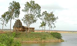
This area was once ruled by the Mauryas, and then later the Sathavahanas. The area was later taken over by the Kadambas, who were soon displaced by the Chalukyas of Badami. An inscription from Anaji dating to the 9th century CE indicates a branch of the Pallavas called the Nolambas ruled part of the district. Part of the district was briefly conquered by a branch of the Gangas in Asandi. By the middle of the 8th century, the Rashtrakutas from Malkhed had established supremacy over the Chalukyas, and conquered territory south to Tumkur.

An inscription in the Bagali temple indicates part of Davanagere district was ruled by a Chalukya feudatory of the Rashtrakutas in the 10th century. Other parts continued to be ruled by the Nolambas as feudatories of the Rashtrakutas. When Rashtrakuta power began collapsing, the Nolambas switched their loyalty to the Gangas and fought against the Chola invasions. When the Chalukyas of Kalyani gained in power, the Nolambas became loyal to them. When the Cholas sacked Kampli, they appointed some of their Pandya vassals as governors of Nolambavadi corresponding to part of Davanagere. The Kalachuris, who were also feudatories of the Chalukyas, were soon given charge of the entire south of Chalukya domains. Their ruler Bijjala II overthrew the Chalukyas and his dynasty ruled until 1181, when the Chalukya prince Someshwara IV took back the throne.

Briefly the Hoysalas ruled parts of Davanagere district in the late 12th century before the region was taken by the Yadavas of Devagiri. The Yadava and Hoysala rule in the region was overthrown by the invasions of Malik Kafur of the Delhi Sultanate in the 14th century, but soon the district came under the control of the Vijayanagara Empire direct from Vijayanagara.

After the Vijayanagara Empire was severely weakened in 1565 after the Battle of Talikota, the local nayakas in Davanagere started asserting their independence. Some of these chiefs were allowed to rule as feudatories of the Adlil Shahis of Bijapur. Both the Mughals and Marathas briefly captured forts in the district. In 1763, one of these families, the Nayaks of Belagutti, submitted to Hyder Ali and the district was under the rule of Mysore. Dhondia Wagh of Channagiri who had created an independent principality resisted the Britishers after Tipu Sultan's defeat until his death in 1800. The district then was kept by Mysore state.

Geography

Some parts of Davanagere district lies in the plain region on the Deccan Plateau locally known as Bayaluseeme and western parts of the district lies in Malnad region locally known as Malenadu. The district is bounded by Haveri district in the northwest, Shimoga district in the southwest, Chikmagalur district in the south, Chitradurga district in the southeast and Vijayanagara district in the north. The district lies in the center of Karnataka between the latitudes 13°5' and 14°50' N and between the longitudes 75°30' and 76°30' E. There are many windy places within the district favouring the recent growth of wind energy industry across the district. The district has an area of 5,926 km2 (2,288 sq mi).

Economy

In 2006 the Ministry of Panchayati Raj named Davanagere one of the country's 250 most backward districts (out of a total of 640). It is one of the five districts in Karnataka currently receiving funds from the Backward Regions Grant Fund Programme (BRGF). [2]

Demographics

Historical population
YearPop.±% p.a.
1901401,990    
1911418,715+0.41%
1921390,009−0.71%
1931451,392+1.47%
1941497,221+0.97%
1951584,822+1.64%
1961735,937+2.32%
1971956,654+2.66%
19811,266,945+2.85%
19911,559,222+2.10%
20011,790,952+1.40%
20111,945,497+0.83%
source: [3]
Religion in Davanagere district (2011) [4]
ReligionPercent
Hinduism
84.38%
Islam
14.47%
Other or not stated
1.15%

According to the 2011 census Davanagere district has a population of 1,945,497 [5] roughly equal to the nation of Lesotho [6] or the US state of West Virginia. [7] This gives it a ranking of 241 amongst a total of 640 districts in India. The district has a population density of 329 inhabitants per square kilometre (850/sq mi). Its population growth rate over the decade 2001–2011 was 8.71%. Davanagere has a sex ratio of 967 females for every 1000 males, and a literacy rate of 76.3%. After transfer of Harapanahalli taluk the district had a population of 1,643,494, of which 581,971 (35.41%) live in urban areas. The residual district has a sex ratio of 975 females per 1000 males. Scheduled Castes and Scheduled Tribes make up 318,305 (19.37%) and 182,804 (11.12%) of the population respectively. [5]

Languages in Davanagere district (2011) [8]

   Kannada (77.27%)
   Urdu (13.87%)
   Telugu (3.03%)
   Lambadi (3.01%)
   Marathi (1.04%)
  Others (1.78%)

At the time of the 2011 census, 77.27% of the population spoke Kannada, 13.87% Urdu, 3.03% Telugu, 3.01% Lambadi and 1.04% Marathi as their first language. [8]

Related Research Articles

<span class="mw-page-title-main">Davanagere</span> City in Karnataka, India

Dāvanagere is a city in the centre of the southern Indian state of Karnataka. It is the seventh largest city in the state, and the administrative headquarters of eponymous Davangere district. Hitherto being a cotton hub and hence popularly known before as the Manchester of Karnataka, the commercial ventures of the city is now dominated by education and agro-processing industries. Davanagere became a separate district in 1997, when it was separated from the erstwhile undivided district of Chitradurga for administration conveniences. Davanagere is known for rich culinary traditions which encompass the diversity of entire Karnataka's dishes due to its geographical position in the state as its centre. Notable among them is its aromatic benne dose.

<span class="mw-page-title-main">Raichur district</span> District of Karnataka in India

Raichur District is an administrative district in the Indian state of Karnataka. It is located in the northeast part of the state and is bounded by Yadgir district in the north, Bijapur and Bagalkot district in the northwest, Koppal district in the west, Bellary district in the south, Jogulamba Gadwal district of Telangana and Kurnool district of Andhra Pradesh in the east.

<span class="mw-page-title-main">Chikmagalur district</span> District of Karnataka in India

Chikmagalur, officially Chikkamagaluru is an administrative district in the Malnad subregion of Karnataka, India. It was called Kadur (Cuddoor) district till 1947. Coffee was first cultivated in India in Chikmagalur. The hills of Chikmagalur are parts of the Western Ghats and the source of Tunga and Bhadra rivers. Mullayanagiri, the highest peak in Karnataka is located in the district. The area is well known for the Sringeri Mutt that houses the Dakshina Peeta established by Adi Shankaracharya.

<span class="mw-page-title-main">Haveri district</span> District of Karnataka in India

Haveri is a district in the state of Karnataka, India. As of 2011, it had a population of 1,597,668, out of which 20.78% were urban residents. The district headquarters is Haveri.And Ranebennur is the biggest city in Haveri district with population & the Commercial city & Business Head quarters & Seeds production Hub

<span class="mw-page-title-main">Bagalkot district</span> District of Karnataka in India

Bagalkot district, is an administrative district in the Indian state of Karnataka. The district headquarters is located in the town of Bagalkot. The district is located in northern Karnataka and borders Belgaum, Gadag, Koppal, Raichur and Bijapur. The new Bagalkot district was carved out of Vijayapura in 1997 via Government of Karnataka directive Notification RD 42 LRD 87 Part III. The bifurcated Bagalkot district consists of ten taluks — Badami, Bagalkot, Bilagi, Guledgudda, Rabkavi Banhatti, Hunagund, Ilkal, Jamakhandi and Mudhol, Teradal.

<span class="mw-page-title-main">Kalaburagi district</span> District of Karnataka in India

Kalaburagi district, formerly known as Gulbarga district, is one of the 31 districts of Karnataka state in southern India. Kalaburagi city is the administrative headquarters of the district. The district is the headquarters of Kalaburagi division.

<span class="mw-page-title-main">Solapur district</span> District of Maharashtra in India

Solapur district is a district in Maharashtra state of India. The city of Solapur is the district headquarters. It is located on the south east edge of the state and lies entirely in the Bhima and Seena basins. The entire district is drained by the Bhima River.

<span class="mw-page-title-main">North Karnataka</span> Region in Karnataka, India

North Karnataka is a geographical region in Deccan plateau from 300 to 730 metres elevation that constitutes the region of the Karnataka state in India and the region consists of 14 districts. It is drained by the Krishna River and its tributaries the Bhima, Ghataprabha, Malaprabha, and Tungabhadra. North Karnataka lies within the Deccan thorn scrub forests ecoregion, which extends north into eastern Maharashtra.

<span class="mw-page-title-main">Shimoga district</span> District of Karnataka in India

Shimoga district, officially known as Shivamogga district, is a district in the Karnataka state of India. A major part of Shimoga district lies in the Malnad region or the Sahyadri. Shimoga city is its administrative centre. Jog Falls view point is a major tourist attraction. As of 2011 Shimoga district has a population of 17,52,753. There are seven taluks: Soraba, Sagara, Hosanagar, Shimoga, Shikaripura, Thirthahalli, and Bhadravathi. Channagiri and Honnali were part of Shimoga district until 1997 when they became part of the newly formed Davanagere district.

Bankapura is a panchayat town in Haveri district in the state of Karnataka, India. It is in Shiggaon taluk, is just 2.5 km from the Pune-Bangalore national highway NH-4, 22 km from Haveri town. Bankapura is about 45 km from Hubli-Dharwad. An historical site, Bankapura is famous for the Nagareshwara temple, Bankapura fort, The Bankapura Peacock Sanctuary. Baada, the birthplace of Kanakadasa is near to Bankapura.

Channagiri is a town in Davanagere district in the state of Karnataka, India. It is a taluk headquarters in Davanagere District from 1997. Before it was the part of Shivamogga District.

<span class="mw-page-title-main">Tourism in Karnataka</span>

Karnataka, the sixth largest state in India, was ranked as the third most popular state in the country for tourism in 2014. It is home to 507 of the 3600 centrally protected monuments in India, second only to Uttar Pradesh. The State Directorate of Archaeology and Museums protects an additional 752 monuments and another 25,000 monuments are yet to receive protection.

<span class="mw-page-title-main">History of Karnataka</span>

The History of Karnataka goes back several millennia. Several great empires and dynasties have ruled over Karnataka and have contributed greatly to the history, culture and development of Karnataka as well as the entire Indian subcontinent. The Chindaka Nagas of central India Gangas, Rashtrakutas of Manyakheta, Chalukyas of Vengi, Yadava Dynasty of Devagiri were all of Kannada origin who later took to encouraging local languages.

<span class="mw-page-title-main">Political history of medieval Karnataka</span> History of Karnataka region of India

The political history of medieval Karnataka spans the 4th to the 16th centuries in Karnataka region of India. The medieval era spans several periods of time from the earliest native kingdoms and imperialism; the successful domination of the Gangetic plains in northern India and rivalry with the empires of Tamilakam over the Vengi region; and the domination of the southern Deccan and consolidation against Muslim invasion. The origins of the rise of the Karnataka region as an independent power date back to the fourth-century birth of the Kadamba Dynasty of Banavasi which was the earliest of the native rulers to conduct administration in the native language of Kannada in addition to the official Sanskrit.

Chigateri is a village in the Harapanahalli Taluk of Vijayanagara District of Karnataka, India.

Uchangidurga is a main Holy & Historical village/town in Harapanahalli Taluk of Vijayanagara District in Karnataka, India. It is 29km away from both Harapanahalli and Davanagere, it is located on state highway 47 & it comes under Harapanahalli taluk of Vijayanagara district in Karnataka.

Ballari pronounced is a historic city in Bellary district in Karnataka state, India.

<span class="mw-page-title-main">Kadamba architecture</span>

Kadamba architecture was a style of temple architecture founded by Mayurasharma in the 4th century AD in Karnataka, India. Kadambas created new style of architecture which was the basis of the Hoysalas style of architecture, developed original school of sculpture, was the forerunner of series of South Indian sculptors. Many temples at Aihole, Badami and Hampi are built in Kadamba style.

<span class="mw-page-title-main">Outline of Karnataka</span> Overview of and topical guide to Karnataka

The following outline is provided as an overview of and topical guide to Karnataka:

<span class="mw-page-title-main">Kannada inscriptions</span> Inscription

About 25,000 inscriptions found in Karnataka and nearby states belong to historic Kannada rulers, including the Kadambas, the Western Ganga Dynasty, the Rashtrakuta, the Chalukya, the Hoysala and the Vijayanagara Empire. Many inscriptions related to Jainism have been unearthed. The inscriptions found are generally on stone (Shilashasana) or copper plates (Tamarashasana). These Kannada inscriptions are found on historical hero stones, coins, temple walls, pillars, tablets and rock edicts. They have contributed towards Kannada literature and helped to classify the eras of Proto Kannada, Pre Old Kannada, Old Kannada, Middle Kannada and New Kannada. Inscriptions depict the culture, tradition and prosperity of their era. The literature of Ramayana and Mahabharata are transferred through the generations by these inscriptions. The Hazara Rama Temple and Aranmula Parthasarathy Temple are the best examples of temples associated with Kannada inscriptions.

References

  1. District formation Archived 3 March 2015 at the Wayback Machine The Official Website of Zilla Panchayat, Davangere, Government of Karnataka.
  2. Ministry of Panchayati Raj (8 September 2009). "A Note on the Backward Regions Grant Fund Programme" (PDF). National Institute of Rural Development. Archived from the original (PDF) on 5 April 2012. Retrieved 27 September 2011.
  3. Decadal Variation In Population Since 1901
  4. "Table C-01 Population by Religion: Karnataka". censusindia.gov.in. Registrar General and Census Commissioner of India. 2011.
  5. 1 2 "District Census Handbook: Davanagere" (PDF). censusindia.gov.in. Registrar General and Census Commissioner of India. 2011.
  6. US Directorate of Intelligence. "Country Comparison:Population". Archived from the original on 13 June 2007. Retrieved 1 October 2011. Lesotho 1,924,886
  7. "2010 Resident Population Data". U. S. Census Bureau. Archived from the original on 19 October 2013. Retrieved 30 September 2011. West Virginia 1,852,994
  8. 1 2 "Table C-16 Population by Mother Tongue: Karnataka". www.censusindia.gov.in. Registrar General and Census Commissioner of India.