Kanara

Last updated

Kanara (Canara)
Karavali
Canara.jpg
Kanara (spotlighted in orange) occupies Karnataka's entire seaboard
CountryFlag of India.svg  India
State Karnataka
Largest city Mangalore
HeadquartersUttara Kannada: Karwar

Udupi: Udupi

Dakshina Kannada: Mangalore
Taluks Uttara Kannada: Karwar, Ankola, Kumta, Honnavar, Bhatkal, Sirsi, Siddapur, Yellapur, Mundgod, Haliyal, Joida, Dandeli

Udupi: Udupi, Karkala, Kundapur, Baindur, Brahmavar, Kaup, Hebri

Contents

Dakshina Kannada: Mangalore, Moodabidri, Bantwal, Belthangady, Sullia, Puttur, Kadaba
Area
  Total18,730 km2 (7,230 sq mi)
Languages
  Official Kannada
Time zone UTC+5:30 (IST)
Vehicle registration
Coastline320 km (200 mi)
Sex ratio 1,040 /
LiteracyIncrease2.svg 87.03% (Highest in Karnataka)

Kanara or Canara, also known as Karavali, is the historically significant stretch of land situated by the southwestern coast of India, alongside the Arabian Sea in the present-day Indian state of Karnataka. [1] The subregion comprises three civil districts, namely: Uttara Kannada, Udupi, and Dakshina Kannada. [2] Kassergode was included prior to the States Reorganisation Act.

Etymology

According to historian Severino da Silva, the ancient name for this region is Parashurama Srushti (creation of Parashurama). [3] According to him and Stephen Fuchs, the name Canara is the invention of Portuguese, Dutch, and English people who visited the area for trade from the early sixteenth century onwards. The Bednore Dynasty, under whose rule this tract was at that time, was known to them as the Kannada Dynasty, i.e., the dynasty speaking the Kannada language. "Karāvalli", the Kannada word for 'coast', is the term used by Kannada-speakers to refer to this region. [4] The letter 'd' being always pronounced like 'r' by the Europeans, the district was named by them as 'Canara' (a corruption of the word "Kannada"). This name was retained by the British after their occupation of the district in 1799, and has remained ever since. However, they also say that this issue is controversial. [4]

History

Since antiquity, much of the Canara coast (now spelled as 'Kanara') occupied a culturally distinct area known as Tulu Nadu. [5] Historically, Tulu Nadu lay between the Gangavalli River in the north and the Chandragiri River in the south. [6] Currently, Tulu Nadu consists of the Udupi and Dakshina Kannada districts of Karnataka, and the Manjeshwaram taluk of Kerala. [7] The Uttara Kannada district in general is considered to be the southernmost part of the Konkan coast. [8] Specifically, the littoral region north of the Gangavalli River is traditionally included in the Konkan. [9]

The Portuguese occupied Kanara from 1498–1763. During this period, the geographical extent of Canara stretched from the southern banks of the Kali River in Karwar in the north to the northern banks of the Chandragiri River in Kasaragod in the south. [10]

In 1799, after the conclusion of the Fourth Mysore War, the British took over the region and established the Canara district of the Madras Presidency. The district was bifurcated into the North and South Canara districts in 1859. [11] The North Canara (also sometimes cited as 'North Kanara') district was transferred to the Bombay Presidency whereas the South Canara (also sometimes referred as 'South Kanara') district remained under the jurisdiction of the Madras Presidency. South Canara encompassed the undivided territory of the contemporary Udupi, Dakshina Kannada, and Kasaragod districts. [11]

After India's independence in 1947, the Bombay Presidency was reconstituted as the Bombay State. Following the States Reorganisation Act, 1956, the southern portion of Bombay State was added to Mysore State, which was renamed Karnataka in 1972. Kasaragod was included in Kerala. [12] Subsequently, North and South Canara were renamed Uttara Kannada and Dakshina Kannada respectively. In 1997, Udupi district was carved out of the bigger Dakshina Kannada district. [12]

Geography

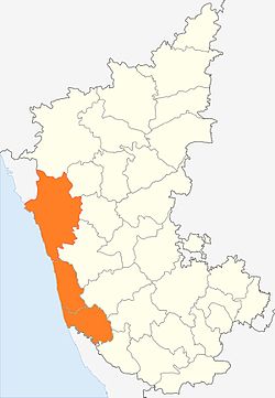
The Kanara region forms the coast of Karnataka situated on the south-western portion of Peninsular India. [13] Coastal Karnataka forms the northern segment of the Malabar coast. [14] Kanara constitutes an area of about 10,000 square kilometres (4,000 square miles). [15] It is bounded by Konkan to the north, the Western Ghats to the east, the Kerala Plains to the south, and the Arabian Sea to the west. [16] It stretches from north to south for about 225 kilometres (140 miles) and has a maximum width of about 64 kilometres (40 miles) in the south. [17]

Civil administration

Contemporary Kanara extends from the village of Majali in the north to the village of Talapady in the south. [10] The three districts in the region: Uttara Kannada, Udupi, and Dakshina Kannada have their capitals in Karwar, Udupi, and Mangalore respectively. [18]

Demographics

Religion in Kanara regions

  Hinduism (76.49%)
  Islam (16.42%)
  Christianity (5.9%)
  Others (1.19%)

The Kanara region have 3 Districts: Uttara Kannada, Udupi, and Dakshina Kannada. The combined population of these districts, according to the 2011 Census is about 47,04,179 .

Languages

Languages of Kanara

  Kannada (31.69%)
  Tulu (29.44%)
  Konkani (13.01%)
  Beary (7.64%)
  Malayalam (4.96%)
  Marathi (3.62%)
  Others (9.64%)

The main languages that are closely associated with the Kanara region are Kannada, Konkani and Tulu.

See also

Notes

^A Konkan is now held to include all the land which lies between the Western Ghats and the Indian Ocean, from the latitude of Daman on the north to that of Terekhol, on the Goa frontier, on the south. [19] Although most sources generally assign Kanara (Karavali) to the Malabar Coast, [15] some other sources consider it to be a subterritory of the Konkan Coast. [20] Consequently, this segment is thought to overlap the Konkan and Malabar Coast continuum; [16] and usually corresponds to the southernmost and northernmost stretches of these locales respectively. [21] [17]

Citations

  1. Arnold, Alison, ed. (2017). "Coastal Karnataka". The Garland Encyclopedia of World Music: South Asia: The Indian Subcontinent. Garland Encyclopedia of World Music. Routledge. ISBN   9781351544382. Coastal Karnataka, formerly called the Canara Coast, is the part of Indias southwestern coastline north of Kerala and south of Goa. [ sic ]
  2. K., Prakashnarayana (2018). "Geography of Karnataka". Know Our Karnataka: A book for Competitive Exams. pp. 27–36. Popularly known as Canara region or Karavali...
  3. Silva 1958 , p. 74
  4. 1 2 Silva & Fuchs 1965 , pp. 1§2
  5. "This city has six names in six languages, and the official one Mangaluru, is the least popular". The News Minute . 6 November 2014. Retrieved 15 September 2019.
  6. Bhatt, P. Gururaja (1969). Antiquities of South Kanara. Prabhakara Press. p. 2.
  7. "Tulu Nadu Region". keralatourism.org. Government of Kerala . Retrieved 15 September 2018.
  8. Charlesworth, Neil (2001). Peasants and Imperial Rule: Agriculture and Agrarian Society in the Bombay Presidency 1850–1935. Cambridge South Asian Studies. Vol. 32 (revised ed.). CUP. p.  60. ISBN   9780521526401.
  9. Memorandum on Maharashtra-Mysore border dispute to the Commission on Maharashtra-Mysore-Kerala boundary disputes. 1967. Government of Maharashtra. p. 59.
  10. 1 2 Shastry, Bhagamandala Seetharama (2000). Borges, Charles J. (ed.). Goa-Kanara Portuguese Relations, 1498–1763. XCHR studies series. Vol. 8. Concept Publishing Company. ISBN   9788170228486.
  11. 1 2 "Chapter 3 – Profile of the Study Area: Coastal Karnataka" (PDF). Shodhganga. Retrieved 15 September 2019.
  12. 1 2 Bhat, N. Shyam (1998). South Kanara, 1799–1860: A Study in Colonial Administration and Regional Response. Mittal Publications. ISBN   9788170995869.
  13. "India: Coastal areas". Encyclopædia Britannica Online . Encyclopædia Britannica, Inc. 16 October 2019. Retrieved 19 October 2019. From Goa south to Cape Comorin (the southernmost tip of India) is the Malabar coastal plain...
  14. Goldberg, Maren (ed.). "Malabar Coast". Encyclopædia Britannica Online . Encyclopædia Britannica, Inc. Retrieved 19 September 2019. Malabar Coast...the southern part of India's western coast, approximately from the state of Goa southward...
  15. 1 2 Pletcher, Kenneth (ed.). "Kanara". Encyclopædia Britannica Online . Encyclopædia Britannica, Inc. Retrieved 19 September 2019. Kanara, region along the Malabar Coast of the Arabian Sea, western Karnataka state, India.
  16. 1 2 Pletcher, Kenneth (ed.). "Karnataka Coast". Encyclopædia Britannica Online . Encyclopædia Britannica, Inc. Retrieved 19 September 2019. Karnataka Coast, coastal lowlands in western Karnataka state, southwestern India... it is bounded by Konkan to the north... The region forms a transitional zone between Maharashtra (north) and Kerala (south) states.
  17. 1 2 Ghori, G.K. (18 September 2019). "Karnataka". Encyclopædia Britannica Online . Encyclopædia Britannica, Inc. Retrieved 19 October 2019. The coastal plain represents a northward continuation of the Malabar Coast...
  18. "Profile of Coastal Karnataka". Coastal Karnataka Calling!!! Tourism and the Coastal Investors Meet – December 2003. 2003. pp. 2–4. Coastal Karnataka consists of three districts - Uttara Kannada, Udupi and Dakshina Kannada. [sic]
  19. Nairne, Alexander Kyd (1988). History of the Konkan. Asian Educational Services. p.  ix. ISBN   9788120602755.
  20. Turley, Jeffrey Scott; Souza, George Bryan (2017). The Commentaries of D. García de Silva y Figueroa on his Embassy to Shāh ʿAbbās I of Persia on Behalf of Philip III, King of Spain. European Expansion and Indigenous Response. BRILL. pp.  163, 222. ISBN   9789004346321. The coastline of the Karnataka region was called Konkan (present-day Karavali) and runs from Thane... to Mangalore. Kanara (Canara or Canera...) is a subregion of Karnataka that forms the southern part of the Konkan coast...
  21. Banerjee, Lalit Kumar (2002). Diversity of coastal plant communities in India. ENVIS & EMCBTAP-Botanical Survey of India, Ministry of Environment & Forests. p.  6. The South of the river Narmada to Mangalore is known as Konkan coast...

Related Research Articles

<span class="mw-page-title-main">Tulu language</span> Dravidian language of Tulu Nadu region

Tulu is a Dravidian language whose speakers are concentrated in Dakshina Kannada and in the southern part of Udupi of Karnataka in south-western India and also in the northern parts of the Kasaragod district of Kerala. The native speakers of Tulu are referred to as Tuluva or Tulu people and the geographical area is unofficially called Tulu Nadu.

<span class="mw-page-title-main">Uttara Kannada</span> District of Karnataka, India

Uttara Kannada is a district in the Indian state of Karnataka. It is a major coastal district of Karnataka, and is the third largest district in Karnataka. It is bordered by the state of Goa and Belagavi districts to the north, Dharwad District and Haveri District to the east, Shivamogga District, and Udupi District to the south, and the Laccadive Sea to the west.

<span class="mw-page-title-main">Mangalore</span> City in Karnataka, India

Mangalore, officially known as Mangaluru, is a major industrial port city in the Indian state of Karnataka and on the west coast of India. It is located between the Laccadive Sea and the Western Ghats about 352 km (219 mi) west of Bangalore, the state capital, 14 km north of Karnataka–Kerala border and 297 km south of Goa. Mangalore is the state's only city to have all four modes of transport—air, road, rail and sea. The population of the urban agglomeration was 619,664 according to the 2011 national census of India. It is known for being one of the locations of the Indian strategic petroleum reserves.

<span class="mw-page-title-main">Kasaragod</span> Municipal city in Kerala, India

Kasaragod is a municipal town and administrative headquarters of Kasaragod district in the state of Kerala, India. Established in 1966, Kasaragod was the first municipal town in the district. It is the northernmost district of Kerala and is also known as Sapta Bhasha Sangama Bhumi.

<span class="mw-page-title-main">Konkan</span> Region of Southwest India

The Konkan is a stretch of land by the western coast of India, bound by the river Daman Ganga at Damaon in the north, to Anjediva Island next to Karwar town in the south; with the Arabian Sea to the west and the Deccan plateau to the east. The hinterland east of the coast has numerous river valleys, riverine islands and the hilly slopes known as the Western Ghats; that lead up into the tablelands of the Deccan. The region has been recognised by name, since at least the time of Strabo in the third century CE. It had a thriving mercantile port with Arab tradesmen from the 10th century. The best-known islands of Konkan are Ilhas de Goa, the site of the Goa state's capital at Panjim, and the Seven Islands of Bombay, on which lies Mumbai, the capital of Maharashtra and the headquarters of the Konkan Division.

<span class="mw-page-title-main">Dakshina Kannada</span> District of Karnataka in India

Dakshina Kannada district is located in the state of Karnataka in India, with its headquarters in the coastal city of Mangalore. It is part of the larger Tulu Nadu region. The district covers an area nestled in between the Western Ghats to its east and the Arabian Sea to its west. Dakshina Kannada receives abundant rainfall during the Indian monsoon. It is bordered by Udupi district to the north, Chikmagalur district to the northeast, Hassan district to the east, Kodagu to the southeast and Kasaragod district of Kerala to the south. According to the 2011 census of India, Dakshina Kannada district had a population of 2,083,625. It is the only district in Karnataka state to have all modes of transport like road, rail, water and air due to the presence of a major hub, Mangalore. This financial district is also known as the Cradle of Indian banking.

<span class="mw-page-title-main">Tulu Nadu</span> Region and proposed state in southern India

Tulu Nadu or Tulunad is a region and a proposed state on the southwestern coast of India. The Tulu people, known as 'Tuluva', speakers of Tulu, a Dravidian language, are the preponderant ethnic group of this region. South Canara, an erstwhile district and a historical area, encompassing the undivided territory of the contemporary Dakshina Kannada and Udupi districts of Karnataka State and Kasaragod district of Kerala state forms the cultural area of the Tuluver.

Havyaka Brahmins also and originally called Havika Brahmana are a Hindu Brahmin community native to districts of Shivamogga,Uttara Kannada, Dakshina kannada and coastal Karnataka, and the Kasaragod district of Kerala. Havyakas are known by their unique culture and language. They fall under the Pancha-Dravida Brahmin category are followers in general of mostly Yajurveda and some Rigveda and Samaveda Shakas. They follow the Advaita philosophy propounded by Adi Shankaracharya.

<span class="mw-page-title-main">South Canara</span> District of British India in Madras, British Raj

South Canara was a district of the Madras Presidency of British India, located at 13.00°N 75.40°E. It comprised the towns of Kassergode and Udipi and adjacent villages, with the administration at Mangalore city. South Canara was one of the most heterogeneous areas of Madras Presidency, with Tulu, Malayalam, Kannada, Konkani, Marathi, Urdu, and Beary languages being spoken side by side. It was succeeded by the Tulu-speaking areas of Dakshina Kannada district, the Malayalam-speaking area of Kasaragod district and the Amindivi islands sub-division of the Laccadives, in the year 1956.

<span class="mw-page-title-main">Tulu people</span> Dravidian ethnic group of southwestern India

The Tulu people or Tuluvas are an ethno-linguistic and ethno-cultural group from Southern India. They are native speakers of the Tulu language and the region they traditionally inhabit is known as Tulu Nadu. This region comprises the districts of Dakshina Kannada and Udupi in Karnataka and part of Kasaragod district in Kerala, with Mangalore, Karnataka being the commercial hub. The Census report of 2011 reported a population of 1,846,427 native Tulu speakers living in India.

<span class="mw-page-title-main">Tigalari script</span> Abugida writing system of the Brahmic family

Tigalari, also known as Tulu script, is a Southern Brahmic script which was used to write Tulu, Kannada, and Sanskrit languages. It was primarily used for writing Vedic texts in Sanskrit. It evolved from the Grantha script. It is referred to as Tigalari lipi in Kannada-speaking regions and Tulu speakers call it as Tulu lipi. It bears high similarity and relationship to its sister script Malayalam, which also evolved from the Grantha script.

<span class="mw-page-title-main">Chandragiri River</span> River in India

The Chandragiri River, also known as the Payaswini River in Karnataka and as the Perumpuzha River in Kerala, is the longest river in Kasaragod district, Kerala, India. The River Is A Historical Treasure Of Chemnad. It was named after the Mauryan emperor Chandragupta Maurya.

<span class="mw-page-title-main">Udupi district</span> District of Karnataka in India

Udupi district is an administrative subdivision in the Karnataka state of India, with the district headquarters in the city of Udupi. It is situated in the Canara old north Malabar coastal region. There are seven taluks, 233 villages and 21 towns in Udupi district. The three northern tehsils of Udupi, Kundapur and Karkala, were partitioned from Dakshina Kannada district to form Udupi district on 25 August 1997. Moodabidri was officially declared as new tehsil (taluk), separated from Karkala with effect from 11 January 2018.

<span class="mw-page-title-main">Beary</span> Indian ethnic group

The Beary are a community concentrated along the southwest coast of India, mostly in the Mangalore district of the south Indian state of Karnataka.

<span class="mw-page-title-main">Alupa dynasty</span>

The Alupa dynasty was an ancient ruling dynasty of India. The kingdom they ruled was known as Alvakheda Arusasira and its territory spanned the coastal districts of the modern Indian state known as Karnataka. The Alupas in their prime were an independent dynasty, centuries after reigning due to the dominance of Kadambas from Banavasi, they became feudatory to them. Later they became the vassals of the Chalukyas, Rashtrakutas, Hoysalas with the change in political scenario of Southern India. Their influence over coastal Karnataka lasted for about 1200 years. There is evidence that the Alupas followed the law of matrilineal inheritance (Appekatt/Aliyasantana) since the Alupa king Soyideva was succeeded by his nephew Kulasekhara Bankideva. The legendary king who is credited with introducing matrilineality in Alva Kheda|Tulu Vishaya Kheda is named Bhuta Alupa Pandya The descendants of this dynasty still survive to this date and have spread in the karavali region and they are widely referred to as the Bunt. The Bunts follow Matrilineality instead of the common Patrilineality, and are said to be Nagavanshi Kshatriyas by their maternal origin. They can be identified with their surnames such as Shetty, Rai, Hegde, Alva, Chowta etc. Even though most Bunt are Hindus by faith now, The sizeable section of the community still follows Jainism and they are called Jain Bunt The last Alupa king to have ruled is Kulasekharadeva Alupendradeva whose inscription dated 1444 CE have been found in Mudabidri Jain Basadi.

<span class="mw-page-title-main">Kasaragod district</span> District in Kerala, India

Kasaragod is one of the 14 districts in the southern Indian state of Kerala. Its northern border Thalappady is located just 9 km south to Ullal, which is the southernmost portion of the major port city Mangalore, on the southwestern Malabar coast of India.

Havigannada, also called as Havyaka Bhaashe and Havyaka Kannada, is the dialect of Kannada spoken by Havyaka Brahmins in Malenadu and coastal region of Karnataka.

<span class="mw-page-title-main">Tulu Nadu state movement</span> Formation of separate Tulu Nadu state from Karnataka and Kerala

Tulu Nadu State movement is aimed at increasing Tulu Nadu's influence and political power through the formation of separate Tulu Nadu state from Karnataka and Kerala. Tulu Nadu is a region on the south-western coast of India. It consists of the Dakshina Kannada and Udupi districts of Karnataka and Kasargod district up to the Chandragiri river in Kerala. The Chandragiri River has traditionally been considered a boundary between Tulu Nadu and Kerala from the fourth century AD onwards. The first call for a separate Tulu Nadu state was made just after the Quit India Movement in 1942 by Srinivas Updhyaya Paniyadi, a banker and a press owner from Udupi. Mangalore is the largest and the chief city of Tulu Nadu. Tulu activists have been demanding a separate Tulu Nadu state since the late 2000s, considering language and culture as the basis for their demand.

<span class="mw-page-title-main">Canarese Konkani</span> Regional language between Goa and Mara

Canarese Konkani are a set of dialects spoken by minority Konkani people of the Canara sub-region of Karnataka, and also in Kassergode of Kerala that was part of South Canara.

<span class="mw-page-title-main">History of Kasaragod</span>

Kasaragod District is the northernmost district in the southwestern Indian coastal state of Kerala. The district has a long history starting from pre-historic times to the modern period.

References

Further reading