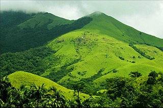
Madikeri is a hill station town in Madikeri taluk and headquarters of Kodagu district in Karnataka, India.

Kasaragod is a municipal town and administrative headquarters of Kasaragod district in the state of Kerala, India. Established in 1966, Kasaragod was the first municipal town in the district. It is the northernmost district of Kerala and is also known as Saptha Bhasha Sangama Bhoomi.

Bekal Fort is a medieval fort built by Shivappa Nayaka of Keladi in 1650 AD, at Bekal. It is the largest fort in Kerala, spreading over 40 acres (160,000 m2).

Namakkal is a special grade municipality and the headquarters of Namakkal district in the Indian state of Tamil Nadu. It is the first ISO 14001-2004 certified municipality in Asia for environmental management, specifically the provision and maintenance of water supply, solid waste and sewage management, town planning, lighting and other social services. Namakkal is known as the Egg City due to its large egg production and Transport city.
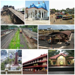
Kanhangad is a town, located in the Kasaragod District, state of Kerala, India.

Chandragiri is a suburb and neighbourhood of Tirupati and located in Tirupati district of the Indian state of Andhra Pradesh. It is a part of Tirupati urban agglomeration and a major growing residential area in Tirupati It is the mandal headquarters of Chandragiri mandal in Tirupati revenue division. It also falls in the jurisdictional limit of Tirupati Urban Development Authority. Chandragiri is the southwestern entrance of Tirupati for vehicles coming from Bangalore, Kerala and Tamil Nadu. Kalyana Venkateswara Temple, Srinivasamangapuram is located next to Chandragiri through which well-laid stone footpaths called srivari mettu are available to reach Tirumala on foot
Nagara is a historic village in the Shivamogga district of the state of Karnataka, India. It is 17 kilometres (11 mi) from Hosanagara or 84 kilometres (52 mi) from Shivamogga. This was called Bidanur (Bidanoor) or Bidnur (Bidanoor) earlier during the 16th century, this was the last capital city of Keladi rulers.

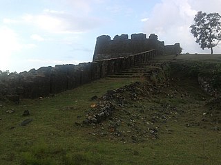
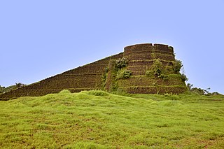
Chandragiri Fort is a fort built in the 17th century, situated in Kasaragod District of Kerala, India. This large squarish fort is 150 feet (46 m) above sea level and occupies an area of about seven acres the adjacent to Chandragiri river. The fort is now in ruins. The fort is located around 59 km south of Mangalore and 87 km north of Kannur at the mouth of the Chandragiri river.

Kanakagiri is a town in Karnataka state of India. It was a provincial capital of the Mauryan Empire and later became the capital of the Nayaka dynasty who were the Palegars (feudatory) of the Vijayanagara Empire. It is also the site of the historical site Kanakachalapathi Temple which was built by the Nayakas.

Chitradurga is a city and the headquarters of Chitradurga district, which is located on the valley of the Vedavati river in the central part of the Indian state of Karnataka. Chitradurga is a place with historical significance which is located to the North West about 200 km from the state capital Bengaluru. Chitradurga is a major tourist hub in Karnataka.
Channagiri is a town in Davanagere district in the state of Karnataka, India. It is a taluk headquarters in Davanagere District from 1997. Before it was the part of Shivamogga District.

Nayakas of Keladi (1499–1763), also known as Nayakas of Bednore and Ikkeri Nayakas, were an Indian dynasty based in Keladi in present-day Shimoga district of Karnataka, India. They were an important ruling dynasty in post-medieval Karnataka. They initially ruled as a vassal of the famous Vijayanagar Empire. After the fall of the empire in 1565, they gained independence and ruled significant parts of Malnad region of the Western Ghats in present-day Karnataka, most areas in the coastal regions of Karnataka, and parts of northern Kerala, Malabar and the central plains along the Tungabhadra river. In 1763 AD, with their defeat to Hyder Ali, they were absorbed into the Kingdom of Mysore. They played an important part in the history of Karnataka, during a time of confusion and fragmentation that generally prevailed in South India after the fall of the Vijayanagar Empire. The Keladi rulers were of the Vokkaliga and Banajiga castes and were Veerashaivas by faith. The Haleri Kingdom that ruled over Coorg between 1600 A.D and 1834 A.D. was founded by a member of the Keladi family.

Chitradurga Fort, or as the British called it Chitaldoorg, is a fortification that straddles several hills and a peak overlooking a flat valley in the Chitradurga District, Karnataka, India. The fort's name Chitrakaldurga, which means 'picturesque fort' in Kannada, is the namesake of the town Chitradurga and its administrative district.

Kasaragod is one of the 14 districts in the southern Indian state of Kerala. Its northern border Thalappady is located just 10 km south to Ullal, which is the southernmost portion of the major port city Mangalore, on the southwestern Malabar coast of India.

Tiruchirappalli Rockfort, locally known as Malaikottai, is a historic fortification and temple complex built on an ancient rock. It is located in the city of Tiruchirappalli, on the banks of river Kaveri, Tamil Nadu, India. It is constructed on an 83 metres (272 ft) high rock. There are two Hindu temples inside, the Ucchi Pillayar Temple, Rockfort and the Thayumanaswami Temple, Rockfort. Other local tourist attractions include the famous Pallava-era Ganesha temple and the Madurai Nayak-era fort. The fort complex has witnessed fierce battles between the Madurai Nayakas and Adil Shahi dynasty of Bijapur, Carnatic region and Maratha Imperial forces. The fort played an important part during the Carnatic Wars, helping lay the foundations of the British Empire in India. The Rockfort is the most prominent landmark of the city.
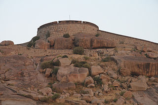
The Bellary Fort was built on top of a hill called the "Ballari Gudda" or the Fort Hill. It is situated in the historic city of Bellary, in the Bellary district, in Karnataka state, India. It was built in two parts namely, the Upper Fort and the Lower Fort. The Upper Fort was built by Hanumappa Nayaka, a feudatory of Vijayanagara Empire, but the Lower Fort was built by Hyder Ali in later part of the 18th century.

Hosdurg is one of four taluks that constitute the Kasaragod District, Kerala. Others are Kasaragod, Manjeshwaram and Vellarikundu taluks. In the north, it borders Kasaragod taluk; in south, the Kannur District; in the east, Vellarikundu taluk; and in the west, the Arabian sea. With an area of 900.3 km2, it was the smaller of the two taluks. Then Hosdurg bifurcated into Vellarikund and Hosdurg taluks in 2013 for ease of administration. Kanhangad and Nileshwaram are the municipalities within the taluk. Hosdurg is a kilometer south of Kanhangad town, the latter being the taluk headquarters. Other major settlements include Trikarpur, Cheruvathur and Udma. Bekal Fort tourism is situated in the taluk. The name Hosdurg comes from the Kannada word hosa ("new") and Sanskrit word durg ("fort").

Warangal Fort is located in Warangal District, Telangana, India. It was the capital city of Kakatiya dynasty and Musunuri Nayakas. It appears to have existed since at least the 12th century when it was the capital of the Kakatiyas. The fort has four ornamental gates, known as Kakatiya Kala Thoranam, that originally formed the entrances to a now ruined great Shiva temple. The Kakatiyan arch has been adopted and officially incorporated into the emblem of Telangana after the bifurcation of Andhra Pradesh. The fort is included in the "tentative list" of UNESCO World Heritage Site and was submitted by the Permanent Delegation of India to UNESCO on 10/09/2010.

Kasaragod District is the northernmost district in the southwestern Indian coastal state of Kerala. The district has a long history starting from pre-historic times to the modern period.
Arikadi fort is a fort located in the Kasaragod district of Kerala, India. It is also known as Kumbla fort. The fort is located at a distance of 2 km from Kumbla on the NH 66 National Highway between kumbala River and shiriya River There is a Hanuman temple just below the fort.
