Alappuzha district, is one of the 14 districts in the Indian state of Kerala. It was formed as Alleppey district on 17 August 1957, the name of the district being changed to Alappuzha in 1990, and is the smallest district of Kerala. Alleppey town, the district headquarters, was renamed Alappuzha in 2012, even though the anglicised name is still commonly used to describe the town as well as the district.

Kottayam, is one of 14 districts in the Indian state of Kerala. Kottayam district comprises six municipal towns: Kottayam, Changanassery, Pala, Erattupetta, Ettumanoor, and Vaikom. It is the only district in Kerala that neither borders the Arabian Sea nor any other states.
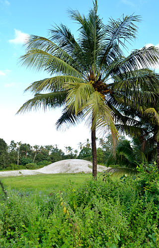
Kokkamangalam also known as Gokkamangalam is a village in Alappuzha district of Kerala state, south India. It is situated in between Cochin and Kumarakom and on the western shore of Vembanad Lake, 5 km east of the town of Cherthala, which has the nearest railway station.

Kumarakom is a popular tourism destination located near the city of Kottayam, in Kerala, India, famous for its backwater tourism. It is set in the backdrop of the Vembanad Lake, the largest lake in the state of Kerala. In January 2023, when Kerala was chosen by the New York Times as one among the 52 must-see tourist destinations in the world, Kumarakom got a special mention for its backwater tourism.

The Kerala backwaters are a network of brackish lagoons and canals lying parallel to the Arabian Sea of the Malabar coast of Kerala state in south-western India. It also includes interconnected lakes, rivers, and inlets, a labyrinthine system formed by more than 900 km (560 mi) of waterways, and sometimes compared to bayous. The network includes five large lakes linked by canals, both man made and natural, fed by 38 rivers, and extending virtually half the length of Kerala state. The backwaters were formed by the action of waves and shore currents creating low barrier islands across the mouths of the many rivers flowing down from the Western Ghats range. In the midst of this landscape there are a number of towns and cities, which serve as the starting and end points of backwater cruises. There are 34 backwaters in Kerala. Out of it, 27 are located either closer to Arabian Sea or parallel to the sea. The remaining 7 are inland navigation routes.
Vembanad is the longest lake in India, as well as the largest lake in the state of Kerala. The lake has an area of 230 square kilometers and a maximum length of 96.5 km. Spanning several districts in the state of Kerala, it is known as Vembanadu Lake in Kottayam, Vaikom, Changanassery, Punnamada Lake in Alappuzha, Punnappra, Kuttanadu and Kochi Lake in Kochi. Several groups of small islands including Vypin, Mulavukad, Maradu, Udayamperoor, Vallarpadam, Willingdon Island are located in the Kochi Lake portion. Kochi Port is built around the Willingdon Island and the Vallarpadam island.

Kuttanad is a region covering the Alappuzha, Kottayam and Pathanamthitta Districts, in the state of Kerala, India, well known for its vast paddy fields and geographical peculiarities. The region has the lowest altitude in India, and is one of the few places in the world where farming is carried on around 1.2 to 3.0 metres below sea level. Kuttanad is historically important in the ancient history of South India and is the major rice producer in the state. Farmers of Kuttanad are famous for Biosaline Farming. Food and Agriculture Organization (FAO) has declared the Kuttanad Farming System as a Globally Important Agricultural Heritage System (GIAHS).
Alappuzha or Alleppey is the administrative headquarters of Alappuzha district in state of Kerala, India. The Backwaters of Alappuzha are one of the most popular tourist attractions in India which attracts millions of domestic and international tourists.

Kainakary is a village in Kuttanad Taluk in Alappuzha District of the Indian state of Kerala.

Muhamma is a census town in Cherthala Taluk in Alappuzha district in the Indian state of Kerala. It is home to Cheerappanchira kalari, where Lord Ayyappa of Sabarimala had his training in the martial arts. Cheerappanchira is an Ezhava ancestral home in Muhamma. Muhamma was the village where the Communist Party of India (Marxist) leader P. Krishna Pillai died after sustaining a snake-bite. Pathiramanal island, one of the scenic spots in vembanad lake is a part of Muhamma Panchyath.Muhamma boat jetty offers ferry services to Kumarakom and Alappuzha. Pathiramnal island can be accessed by private owned boats and also by government operated water transport.
Thanneermukkom is a village in Alappuzha district of Kerala, India.
Thycattusserry is a village in the Cherthala taluk of the Alappuzha district in the Indian state of Kerala.

Vechoor is a village in Vaikom taluk, Kottayam district in the state of Kerala, India. Vechoor is a short drive away from one of Kerala's tourist destinations, Kumarakom. The Vechur Cow breed of cattle is named after this village.

The West Coast Canal or National Waterway No 3 is a 205 km (127 mi) long inland navigational route located in Kerala, India, which runs from Kollam to Kottapuram. It was declared a National Waterway in 1993. In addition to the main stretch, Champakara and Udyogmandal canals are navigable and connect the industrial centers of Kochi to Kochi port Inland Waterways Authority of India (IWAI) under the Ministry of Shipping is coordinating the task for developing, monitoring and administering national waterways. It is the first National Waterway in the country with 24-hour navigation facilities along the entire stretch. It has been extended to Kozhikode by the National Waterways Act, 2016. The National Waterway 3 mainly passes through the previous Thiruvananthapuram–Shoranur canal.
Manimala River or Manimalayar is a 92km long river which flows through South and Central Kerala. The river used to be wrongly considered as a tributary of Pamba River before satellite maps became popular, but this was proved incorrect. Manimala does not flow into the Pamba, instead a distributary of the Pamba river flows into the Manimala river at Kallunkal, later branches out again from Manimala at Nedumpuram and flows through Niranam, Thalavady, Edathua, Changankary, Champakulam, Nedumudy, Chennamkary, and finally Kainakary and then empties into the Vembanad lake. This branch again links with Manimala river at Chennankary in a short, but broad connection known as Munnattumukham.

State Highway 11 is a State Highway in Kerala, India that starts in Kalarcode, Alappuzha and ends in Perunna, Changanassery.The road is popularly known as AC road road. The highway is 24.2 km long.
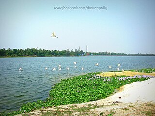
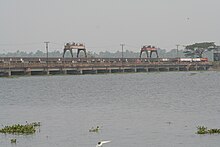
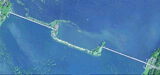
Thottappally is a village in Alappuzha district in the state of Kerala, India. Thottappally is especially notable for Thottappally Spillway, a spillway cum bridge on the National Highway 66 between Alappuzha and Thiruvananthapuram. The spillway is one of the two regulators used to regulate waterlevel in the paddy fields of Kuttanad, the other being at Thanneermukkom. Thottappally is Kuttanad's drain-way-out to the Arabian Sea. The Thottappally Spillway splits the Thottappally lake with the fresh water part to the east and saline Thottappally rivermouth to the west merging with the Arabian Sea. The beach and fishing harbour of Purakkad, which got into fame through the celebrated film and novel Chemmeen, is adjacent to Thottappally.

The following outline is provided as an overview of and topical guide to Kerala:
Parayakad, Alappuzha is a village in Kuthiathode gram panchayat, India. in Cherthala Taluk in Alappuzha district in the Indian state of Kerala. There is another place known as Parayakad or Parayad in Ernakulum District. This is a small area / block (muri) in Chittattukara Village in North Paravoor. Parayakad Village in Alleppey district is listed in the Central Government Indian Village Directory. Kuthiathode comes under the Pattanakad Block in Aroor Assembly constituency.
Waterways have always been an important mode of transport in Kerala. The total length of navigable route in Kerala was 1,900 kilometres and the navigable rivers constitute about 54 per cent of the waterways. The 41 West-flowing rivers together with the backwaters are an integrated part of the inland navigation system in Kerala. In Kerala water transportation through these channels are mainly small distant passenger services, informal country boats, freight transportation to PSU's such as Fertilisers and Chemicals Travancore, Kochi etc.