Kappil, Thiruvananthapuram

Last updated

Kappil
place
India Kerala location map.svg
Red pog.svg
Kappil
Location in Kerala, India
India location map.svg
Red pog.svg
Kappil
Kappil (India)
Coordinates: 8°46′49″N76°40′35″E / 8.78028°N 76.67639°E / 8.78028; 76.67639
CountryFlag of India.svg  India
State Kerala
District Thiruvananthapuram
Government
  BodyEdava Panchayat
Area
  Total3 km2 (1 sq mi)
Languages
  Official Malayalam
Time zone UTC+5:30 (IST)
PIN
695311 [1]
Telephone code0471
Vehicle registration KL 81 [2]
Nearest city Thiruvananthapuram
Niyamasabha constituency Chathannor
Website https://trivandrum.nic.in/en/

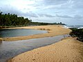
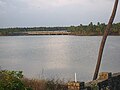
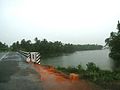
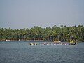
Kappil is a seashore tourist spot located in Thiruvananthapuram district, Kerala, India. Varkala railway station is the major railway station near Kappil. [3]

Contents

Transportation

Road

Kappil lies on the Varkala - Paravur - Kollam Road.

Rail

Air

Trivandrum International Airport, located 46 km away.

Tourism

Kappil beach Kappil beach 02.jpeg
Kappil beach
Kappil beach sunset Kappil beach sunset.jpeg
Kappil beach sunset

Scenic backwaters, beach and facilities for watersport are available.

Kappil is also famous for the Kappil Bhagavathy Temple and is a tourist spot during the festival season.

Nearby Places

Related Research Articles

<span class="mw-page-title-main">Kovalam</span> Beach and seaside resort in Thiruvananthapuram, Kerala

Kovalam is a beach and seaside resort in the city of Thiruvananthapuram in Kerala, India. Kovalam is located 12.6 km (7.8 mi) southeast of the city center. The beaches around Kovalam are popular vacation destinations for both domestic and international travellers.

<span class="mw-page-title-main">Varkala</span> Town in Kerala, India

Varkala is a major coastal municipality situated in the northern suburb of Trivandrum, capital city of the Indian state of Kerala.

<span class="mw-page-title-main">Kerala backwaters</span> Lagoon network in India

The Kerala backwaters are a network of brackish lagoons and canals lying parallel to the Arabian Sea of the Malabar coast of Kerala state in south-western India. It also includes interconnected lakes, rivers, and inlets, a labyrinthine system formed by more than 900 km (560 mi) of waterways, and sometimes compared to bayous. The network includes five large lakes linked by canals, both man made and natural, fed by 38 rivers, and extending virtually half the length of Kerala state. The backwaters were formed by the action of waves and shore currents creating low barrier islands across the mouths of the many rivers flowing down from the Western Ghats range. In the midst of this landscape there are a number of towns and cities, which serve as the starting and end points of backwater cruises. There are 34 backwaters in Kerala. Out of it, 27 are located either closer to Arabian Sea or parallel to the sea. The remaining 7 are inland navigation routes.

<span class="mw-page-title-main">Kollam district</span> District in Kerala, India

Kollam district, is one of 14 districts of the state of Kerala, India. The district has a cross-section of Kerala's natural attributes; it is endowed with a long coastline, a major Laccadive Sea seaport and an inland lake. The district has many water bodies. Kallada River is one among them, and land on the east bank of the river is East Kallada and that on the west bank is West Kallada.

<span class="mw-page-title-main">Thiruvananthapuram district</span> District in Kerala, India

Thiruvananthapuram District is the southernmost district in the Indian state of Kerala. The district was created in 1949, with its headquarters in the city of Thiruvananthapuram, which is also Kerala's administrative centre. The present district was created in 1956 by separating the four southernmost Taluks of the erstwhile district to form Kanyakumari district. The city of Thiruvananthapuram is also known as the Information technology capital of the State, since it is home to the first and largest IT park in India, Technopark, established in 1990. The district is home to more than 9% of total population of the state.

<span class="mw-page-title-main">Parippally</span> Village in Kerala, India

Parippally is a village in kalluvathukkal panchayat Kollam, Kerala, India. Parippally is 22 kilometres (14 mi) South of Kollam City along NH66 and 44 kilometres (27 mi) North of Thiruvananthapuram along NH66. Kollam Govt. Medical College is situated in Parippally. Varkala sivagiri is nearest major Railway station 12 km(7.5 mi).

The Thiruvananthapuram - Shoranur canal is a historic canal in India, from Trivandrum to Shoranur. It was one of the most arterial transportation mode in erstwhile Travancore princely state. Most of the trade, commerce and freight traffic in Travancore used to happen through this canal. The canal used to pass through rice bowl of the state, Kuttanad, centre of Coir trade i.e. Alappuzha, centre of Cashew business, Kollam, Changanassery market, strategic Thevally, Kayamkulam, Varkala etc. and used to connect Thiruvithamkoor with Cochin State and Malabar.

<span class="mw-page-title-main">Paravur Lake</span> Lake in Paravur, Kollam

Paravur Kayal is a lake in Paravur, Kollam district, Kerala, India. Although it is small, with an area of only 6.62 km², it is the end point of the Ithikkara River and part of the system of lakes and canals that make up the Kerala Backwaters. It has been connected to Edava and Ashtamudi Kayal as part of the Trivandrum - Shoranur canal system since the late 19th century.

Karunagappally is a municipality in the Kollam district of Kerala, India. It is 24 km north of Kollam and 60 km (37 mi) south of Alappuzha. Karunagappally taluk consists of Alappad, Ochira, Adinad, Karunagappally, Thazhava, Pavumba, Thodiyoor, Kallalibhagom, Thevalakkara, Chavara, Neendakara, Clappana, Kulasekharapuram, Thekkumbhagam, Ayanivelikulangara, Panmana, Ponmana and Vadakumthala. The taluk is bound on the north by Kayamkulam, on the east by Kunnathur taluk, on the south by Kollam and on the west by the Arabian Sea. It is one of the fastest developing towns in Kerala and is part of Kollam metropolitan area.

<span class="mw-page-title-main">Edava</span> Village in Kerala, India

Edava is a panchayat in Varkala Taluk of Trivandrum district in the state of Kerala, India. Edava is located 5km north of Varkala, 21km south of port city Kollam and 44km north of capital city Trivandrum. Kappil beach is a famous surf location.Surfsupkerala life saving club operates here.

<span class="mw-page-title-main">Chirayinkeezhu</span> Taluk in Kerala, India

Chirayinkeezhu is a town in Thiruvananthapuram district in the Indian state of Kerala. It was also hometown of famous Malayalam Film actor Prem Nazir. It is the seat of Chirayinkeezhu taluk.

Perunguzhi is a village in Chirayinkeezh Taluk, Thiruvananthapuram District, Kerala. It is under the jurisdiction of Azhoor Panchayat. There are many temples and backwaters. It is situated 19km south of Varkala and 22km north of Trivandrum City.

Varkala Sivagiri railway station, station code VAK, is a major railway station in Kerala serving the town of Varkala in Thiruvananthapuram. It is the second-busiest railway station in the state capital district Trivandrum in terms of passenger movement and 14th busiest in Kerala State. Around 54 trains halts in this station which handled more than 17,730 passengers daily with 3 platforms. It is on Kollam–Thiruvananthapuram trunk line. Station is well connected to major metropolitan & tier 2 cities like Trivandrum, Hyderabad, Kochi, Delhi, Bangalore, Mangalore, Chennai, Mumbai, Vijayawada, Kolkata, Goa etc.

<span class="mw-page-title-main">Paravur railway station</span> Railway station in Paravur, Kollam

Paravur railway station(Code:PVU) is a railway station in the Indian municipal town of Paravur in Kollam district, Kerala. Paravur railway station falls under the Thiruvananthapuram railway division of the Southern Railway zone of Indian Railways. It is a 'NSG 5' class railway station coming under the Southern Railway zone.

<span class="mw-page-title-main">Thekkumbhagam</span> Neighbourhood in Kollam, Kerala, India

Thekkumbhagam or Thekkumbhagom is the southern border town of Paravur municipality in the Kollam district of Kerala, India. It is located at the Southern tip of Kollam's coastal area. It is in the Arabian Sea coast. Thekkumbhagam-Kappil estuary point in the Kollam-Thiruvananthapuram coastal border is one of the emerging tourism spots in the state. On 1936, during formation, Thekkumbhagam was one of the nine territories of Paravur Panchayath. Thekkumbhagam estuary is one among the twin estuary points in Paravur. The other one is Pozhikara estuary.

<span class="mw-page-title-main">Karunagappalli railway station</span> Karunagappalli railway station

Karunagappalli railway station(Code:KPY) or Karunagappally railway station is a railway station in the Indian municipal town of Karunagappalli in Kollam district, Kerala. Karunagappalli railway station falls under the Thiruvananthapuram railway division of the Southern Railway zone of Indian Railways. Karunagappally KSRTC Bus Station is only 2 km away from the station. It is one among the railway stations in Kerala collecting crores of rupees through passenger tickets every year. Karunagappalli is the nearest railway station to Amritapuri. Free WiFi of railway is available here. Karunagappalli is connected to various cities in India like Kollam, Trivandrum, Kochi, Calicut, Palakkad, Thrissur, Punalur, Bengaluru, Udupi, Mumbai, Madurai, Kanyakumari, Vishakapatnam, Mangalore, Pune, Salem, Coimbatore, Trichy, Tirunelveli, Hyderabad etc. through Indian Railways. In 2019, the rail wi-fi broad-band connection has been introduced in Karunagappalli station.karunagappally - KMML Chavara railway line is a defunct railway line which used to carry goods to KMML in past.kothukumukku railway bridge in this old line is a tourist attraction now.

<span class="mw-page-title-main">Estuaries of Paravur</span> Group of Estuaries in Paravur, Kollam

The Paravur Estuaries are a group of estuaries in Paravur, India, near the South-Western coast of Kollam district, Kerala. Paravur is one among the 4 municipal towns in Kollam district, Kerala state. The place is known for its natural beauties, backwater locations, white-sand beaches and concentration of temples.

<span class="mw-page-title-main">Varkala Taluk</span> Taluk in Trivandrum district

Varkala Taluk is a Taluk (tehsil) in Thiruvananthapuram district in the Indian state of Kerala. It is the 3rd most densely populated taluk in the district comprising 10 villages and Varkala municipality. Spanning an area of about 171 km2,Varkala Taluk is home to over 9% of total population of Trivandrum district. Varkala is the taluk headquarters and the largest town of the taluk.

Kappil railway station station code KFI, is one of the four railway stations serving the Varkala urban agglomeration in Thiruvananthapuram district of Kerala. It is situated in Edava Panchayat of Varkala Taluk. It is the 20th most revenue-generating railway station in Trivandrum district. Kappil Beach and lake is situated close to this railway station is one of the major tourist destinations in Trivandrum. In 2018–19 FY Kappil generated ₹1.18lakh profit from 15,529 passengers.

<span class="mw-page-title-main">Puthenkulam</span> Place

Puthenkulam is a small village in Ithikkara block in Kollam district of Kerala state, India. It comes under Poothakkulam Grama panchayath. Puthenkulam postal pincode is 691302. It is located 5 km from Paravur on Paravur - Parippally road. Puthenkulam is known as the 'elephant village' and is a popular tourist spot in Kollam. Approximate driving distance between Kollam railway station to Puthenkulam bus stop is about 22.1 km.

References

  1. "Pin Code of Kappil in Thiruvananthapuram, Kerala". mapsofindia.com. Retrieved 24 October 2018.
  2. https://mvd.kerala.gov.in/en/node/825.{{cite web}}: Missing or empty |title= (help)
  3. "Kappil beach and backwaters". keralatourism.org. Kerala Tourism Department. Retrieved 24 October 2018.