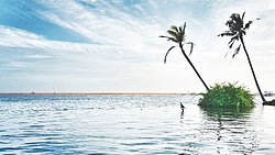
Poovar

Last updated

Poovar
Town
Poovar Kerala.jpg
Poovar beach
India Kerala location map.svg
Red pog.svg
Poovar
Location in Kerala, India
India location map.svg
Red pog.svg
Poovar
Poovar (India)
Coordinates: 8°19′3″N77°4′17″E / 8.31750°N 77.07139°E / 8.31750; 77.07139
CountryFlag of India.svg  India
State Kerala
District Thiruvananthapuram
Languages
  Official Malayalam, English
Time zone UTC+5:30 (IST)
Vehicle registration KL-20

Poovar is a tourist town in Neyyattinkara (tehsil) in the Thiruvananthapuram district of Kerala state, South India. This village is almost at the southern tip of Thiruvananthapuram while the next village, Pozhiyoor, marks the end of Kerala.

Contents

Geography

Poovar lies very close to Vizhinjam, a natural harbour. The beach of Pozhiyoor named Pozhikkara is located near Poovar. The 56 km Neyyar River passes through Neyyattinkara Taluk into the Arabian Sea near Poovar. [1]

History

Poovar was a trading centre of timber, sandalwood, ivory and spices. It is believed that ships owned by King Solomon of Israel landed in Ophir, which is identified by some sources as Poovar, [2] [3] The village was one of the ancient Muslim settlements along the western coast of India. The central mosque in Poovar was built by Malik Deenar, an eighth century Muslim preacher. During the reign of the Chola dynasty, Poovar was a major port. The explorer Megasthenes, Roman writer Pliny the Elder and Venetian traveller Marco Polo mention connections with Greece and Rome.[ citation needed ]

The origin of the name "Poovar" has a story related to Marthanda Varma. Before that it was called Pokkumoosapuram. There were a merchant named Pokku Moosa Maraikkar who lived in Poovar during the 18th century in a house called Kallaraickal Tharavad, which many times gave shelter to Marthanda Varma (1706–58), king of Travancore from his enemies.Pokku Moosa Maraikkar is believed to have migrated from Malabar somewhere around Kozhikode for trade and finally settled in Poovar.He is believed to be in the lineage of Kunjali Maraikkars.Poovar also had trade relations with international markets at this time as well as a well trained army and some ships. At the Battle of Colachel and Battle of Kayamkulam the forces of Kallaraickal assisted the Travancore army against the Dutch East India Company during the Travancore–Dutch War.[ citation needed ]

During internal riots in Travancore and while escaping from the Ettuveetil Pillamar (Lords of the Eight Houses), the king reached Poovar. It was a spring season and the trees on both sides of the Neyyar were full of flowers. These flowers fell into the river making it more attractive. On seeing this pleasant scenery, Marthanda Varma commented that this was poo-var, a conjunction of the Malayalam words for "flower" and "river". [4]

Related Research Articles

<span class="mw-page-title-main">Travancore</span> Kingdom in southern India from 1729 to 1949

The Kingdom of Travancore, also known as the Kingdom of Thiruvithamkoor, was an Indian kingdom from c. 1729 until 1949. It was ruled by the Travancore Royal Family from Padmanabhapuram, and later Thiruvananthapuram. At its zenith, the kingdom covered most of the south of modern-day Kerala and the southernmost part of modern-day Tamil Nadu with the Thachudaya Kaimal's enclave of Irinjalakuda Koodalmanikyam temple in the neighbouring Kingdom of Cochin. However Tangasseri area of Kollam city and Anchuthengu near Attingal in Thiruvananthapuram were parts of British India.

<span class="mw-page-title-main">Neyyattinkara</span> Suburb of Trivandrum, Kerala, India

Neyyattinkara, is a significant municipal town and a prominent center for both industry and commerce, positioned at the southernmost tip of the Thiruvananthapuram metropolitan area in Trivandrum, the capital of Kerala State. It also serves as the administrative headquarters of Neyyattinkara Taluk.Nestled along the banks of the Neyyar River, one of the district's principal rivers, the town derives its name from its location, with 'Neyyatinkara' in Malayalam translating to 'the shore of the river Neyyar.' Neyyattinkara ranks as the second most densely populated municipality in the district, following Varkala. Notably, the Vizhinjam International Seaport Thiruvananthapuram is situated within Neyyattinkara Taluk."

<span class="mw-page-title-main">Marthanda Varma</span> Maharaja of Travancore from 1729–1758

Anizham Thirunal Marthanda Varma was the founding monarch of the southern Indian Kingdom of Travancore from 1729 until his death in 1758. He was succeeded by Rama Varma (1758–98).

Venad was a medieval kingdom lying between the Western Ghat mountains and the Arabian Sea on the south-western tip of India with its headquarters at the port city of Kollam/Quilon. It was one of the major principalities of Kerala, along with kingdoms of Kannur (Kolathunadu), Kozhikode (Nediyiruppu), and Kochi (Perumpadappu) in medieval and early modern period.

<span class="mw-page-title-main">Thiruvananthapuram district</span> District in Kerala, India

Thiruvananthapuram District is the southernmost district in the Indian state of Kerala. The district was created in 1949, with its headquarters in the city of Thiruvananthapuram, which is also Kerala's administrative centre. The present district was created in 1956 by separating the four southernmost Taluks of the erstwhile district to form Kanyakumari district. The city of Thiruvananthapuram is also known as the Information technology capital of the State, since it is home to the first and largest IT park in India, Technopark, established in 1990. The district is home to more than 9% of total population of the state.

<span class="mw-page-title-main">Battle of Colachel</span> 1741 battle of the Travancore-Dutch War

The Battle of Colachel was fought on 10 August 1741 [O.S. 31 July 1741] between the Indian kingdom of Travancore and the Dutch East India Company. During the Travancore-Dutch War, King Marthanda Varma's (1729–1758) forces defeated the Dutch East India Company's forces led by Admiral Eustachius De Lannoy on 10 August 1741. The Dutch never recovered from the defeat and no longer posed a large colonial threat to India. Travancore won the war with the notable military service of the Travancore nair brigadeat the sea and seashore while Anantha padmanabhan Pillai commander in chief of the army at the land.

Thiruvithamcode, is a small panchayat town located in the Kanyakumari district of the Indian state of Tamil Nadu. Thiruvithamcode is about 20 km from Nagercoil and 2 km from Thuckalay.

<span class="mw-page-title-main">Kilimanoor</span> Town in Kerala, India

Kilimanoor is a panchayat and a town in the Chirayinkeezhu taluk of Thiruvananthapuram district in Kerala, India. It is located on MC/SH 1 Road, 33 kilometres (21 mi) North-west of the city of Thiruvananthapuram (Trivandrum), 14 km (8.7 mi) east of Attingal and 20 km (12 mi) east of Varkala.

The history of Thiruvananthapuram dates back to the 18th century AD. In 1795, the city became the capital of the princely state of Travancore. Several historic landmarks of the city, including the Kowdiar Palace, University of Kerala, and Napier Museum were built during that period. After independence, Thiruvananthapuram was made the capital of the state of Kerala.

<span class="mw-page-title-main">Travancore–Dutch War</span>

The Travancore–Dutch War was a war between the Dutch East India Company (VOC) and the Indian kingdom of Travancore, culminating in the Battle of Colachel in 1741. Travancore won the war with the notable military service of fishermen community at the sea and seashore while Ananthapadmanabhan nadar as commander in chief of the army at the land.

<span class="mw-page-title-main">Thekkumkur</span> Kingdom in Kerala from 1103 to 1750

The Kingdom of Thekkumkur was an independent kingdom in the southern part of Kerala in India from 1103 CE until 1750 CE. It was ruled by the Thekkumkur Royal Family. Thekkumkur lies between the Meenachil River and the Pamba River, from the Western Ghats to the Vembanad Kayal. Thekkumkur emerges as a result of administrative changes in the princely states at the end of the Chera Kulasekhara dynasty of Mahodayapuram. The literal meaning of the title is the southern regent and the attribute southern distinguished them from another kingdom known as Vadakkumkur which bordered it in the northern side. The royal household, Thekkumkur Kovilakam, were at Vennimala and Manikandapuram near Puthuppally, later it shifted to Neerazhi Palace at Puzhavathu of Changanassery and Thalilkotta at Thaliyanthanapuram (Kottayam).

<span class="mw-page-title-main">Eustachius De Lannoy</span> Military commander of the Travancore Army

Eustachius Benedictus de Lannoy was a skilled military strategist and commander of the Travancore Army, under Maharaja Marthanda Varma.

<span class="mw-page-title-main">Nair Brigade</span> Army of the Kingdom of Travancore

The Nair Brigade was the army of the erstwhile kingdom of Travancore in India. Nairs were a warrior community of the region. The personal bodyguard of the king Marthanda Varma (1706–1758) was also called Thiruvithamkoor Nair Pattalam. The Travancore army was officially referred as the Travancore Nair Brigade in 1818.

Pozhiyoor is a village in the district of Thiruvananthapuram in the State of Kerala in India. It has gradually grown to a well known tourist destination in India. The major attractions of Poovar tourism area are in Pozhiyoor. Pozhikkara, estuary formed by river Neyyar before it falls into the mighty Arabian Sea is the centre of attraction of tourism circuit in Poovar. Golden Beach, Elephant Rock, Anantha Victoria Marthanda Varma Canal, Pieta are other major attractions in Pozhiyoor Beach area in Thiruvananthapuram. It is at the coastal border of the Indian states of Kerala and Tamil Nadu.

Chirayinkeezhu Taluk is a Taluk (tehsil) in Thiruvananthapuram district in the Indian state of Kerala. It is shares border with Varkala Taluk in North and with Thiruvananthapuram Taluk in South. It comprises 12 panchayats and Attingal Municipality. Chirayinkeezhu taluk is the birthplace of a host of illustrious personalities like the painter Raja Ravi Varma, the great poet and social reformer Kumaran Asan and Prem Nazir etc.

<span class="mw-page-title-main">Neyyattinkara Sree Krishna Swami Temple</span> Hindu temple in Kerala, India

Neyyattinkara Sree Krishna Swamy Temple is a Hindu temple dedicated to Krishna situated at Neyyattinkara, 20 km (12 mi) south of Thiruvananthapuram in Kerala, India. It is one of the important temples of Krishna in Kerala with great historic importance. The temple enshrines Unnikannan in the form of Navaneetha Krishna as the presiding deity. Thrikkayyilvenna or Thrikkayyil Venna (butter) is a unique offering to Neyyattinkara Unnikannan, the deity of the temple. World famous musicians Sri. Neyyattinkara Mohanachandran and Neyyaattinkara Vasudevan used to perform concerts regularly in temple festival.

Parappanad was a former feudal city-state in Malabar, India. The headquarters of Parappanad Royal family was at the town Parappanangadi in present-day Malappuram district. In 1425, the country divided into Northern Parappanad and Southern Parappanad. Southern Parappanad included parts of Tirurangadi Taluk and the town Parappanangadi. Northern Parappanad included Panniyankara, Beypore, and Cheruvannur of Kozhikkode Taluk. Parappanad royal family is a cousin dynasty of the Travancore royal family.

Marthandanthurai is a coastal village on the shore of the Arabian Sea in Kanyakumari district, Tamil Nadu, India, near the border with Kerala and Tamil Nadu. The village is part of the Kollemcode panchayat. It belongs to the Roman Catholic Archdiocese of Trivandrum from 1967. Prior to joining with the Trivandrum Latin Archdiocese, this village was a part of the Roman Catholic Diocese of Cochin. The village is known for its beauty and versatility. It is a pilgrimage centre of Our Lady of Lourdu and is dedicated to the patronage of Our Lady of Dolours. The historical AVM Canal flows through this village. Its golden sand beach is the attraction of this tourist village. Being the part of Kollemcode Town Panchayat, this is the prime centre of trade and transportation for the neighboring villages. The 30% of people live in Marthandanthurai speak Malayalam as their major spoken language and the remainder speak a mixture of Tamil and Malayalam. In short, it can be said that people have their own colloquial way of talking and language. This language slang has big difference among neighbor regions and villages. Marthandanthurai the name sometimes referred as "Land of Marthanda Varma" because the king who did a lot of favors to this village. The villages of Vallavilai and Neerody are located near the village Marthandanthurai. This Village is located nearly 70 km from Kanyakumari and 30 km from Trivandrum.

The Anantha-Victoria-Marthandam Canal a.k.a. A.V.M. Canal was conceived as a 'water link' between Thiruvananthapuram and Kanyakumari in July 1860 during the reign of Uthradam Thirunal Marthanda Varma Maharaja of Travancore state. Today it is the National Waterway 13 of India.

<span class="mw-page-title-main">Ammachi Plavu</span> Historical Jack-fruit tree

Ammachi Plavu literally translated from Malayalam, it means grandmother Jack-fruit tree or an old Jackfruit tree, Located in inside of Neyyattinkara Sree Krishna Swami Temple in Thiruvananthapuram Kerala.

References

  1. India9.com, Retrieved on 1 July 2008
  2. Nadar, G. Krishnan (2001). History of Kerala. Learners' Book House. p. 41.
  3. Menon, Rekha (1961). Cultural Profiles. Inter-National Cultural Centre. p. 1.
  4. Murickan, Jose (1991). Religion and power structure in rural India: a study of two fishing villages in Kerala : Poovar, Sakthikulangara. Rawat Publications. p. 43. ISBN   9788170331179.