
Kurinjimala Sanctuary protects the approximately 32 hectare core habitat of the endangered Neelakurinji plant in the Kottakamboor and Vattavada villages in Devikulam Taluk, in the Idukki district of Kerala, a state in southern India. [1] [2]
Kurinjimala Sanctuary protects the approximately 32 hectare core habitat of the endangered Neelakurinji plant in the Kottakamboor and Vattavada villages in Devikulam Taluk, in the Idukki district of Kerala, a state in southern India. [1] [2]
According to some historians, the earliest known inhabitants of southern India were hunter-gatherers who inhabited Kurinjimala. [3]
The sanctuary was declared by the Kerala Forest Minister Benoy Viswam at the Neelakurinji Fest at Munnar on 7 October 2006. During the 2006 bloom, massive flowering of Neelakurinji attracted nearly ten lakh (1,000,000) people to Munnar and other places. [4]
The Government notification said that the sanctuary would ensure the long-term protection of the unique biodiversity of the area, especially Strobilanthes kunthiana and its habitat. Private land holdings having legal titles are excluded from the sanctuary area.
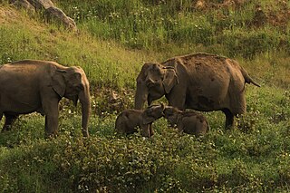
The sanctuary is home to threatened species of elephant, gaur, nilgiri tahr and deer.
The new sanctuary is contiguous to the Chinnar Wildlife Sanctuary to the northwest, Manjampatti Valley in Amaravati Reserve Forest of Indira Gandhi Wildlife Sanctuary to the northeast, Eravikulam National Park and Anamudi Shola National Park to the west, Pampadum Shola National Park to the south and the proposed Palani Hills National Park to the east. The sanctuary provides continuity and connectivity to these five protected areas. [5] [6]
The Indian martial art of Silambam, known to be practiced by the Tamil people, originated in the Kurinji hills. It derives its name from the Tamil word silam, meaning hill, and the Kannada word bamboo from which the English word bamboo originates. The term silambambu referred to a particular type of bamboo from Kurinjimala. [7] The silambam staff is known as neduvadi in Kerala, dhanta varisai in Karnataka, and karra saamu in Andhra Pradesh. [8]
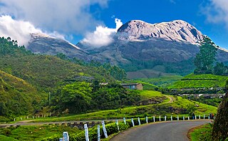
Munnar is a town and hill station in the Idukki district of the southwestern Indian state of Kerala. Munnar is situated at around 1,600 metres (5,200 ft) above mean sea level, in the Western Ghats mountain range. Munnar is also called the "Kashmir of South India" and is a popular honeymoon destination.

Silambam is an Indian martial art originating in Tamilnadu, South India in the Indian subcontinent. This style is mentioned in Tamil Sangam literature. The World Silambam Association is the official international body of Silambam.

Idukki (ഇടുക്കി), IPA: [iɖukːi], is one of the 14 districts in the Indian state of Kerala. Idukki district lies amid the Cardamom Hills of Western Ghats in Kerala. Idukki district contains two municipal towns - Kattappana and Thodupuzha. The district currently includes five taluks in it.
The Cardamom Hills or Yela Mala are mountain range of southern India and part of the southern Western Ghats located in Idukki district, Kerala, India. Their name comes from the cardamom spice grown in much of the hills' cool elevation, which also supports pepper and coffee. The Western Ghats and Periyar Sub-Cluster including the Cardamom Hills are UNESCO World Heritage Sites.

The Anamala or Anaimalai, also known as the Elephant Mountains, are a range of mountains in the southern Western Ghats of central Kerala and span the border of western Tamil Nadu in Southern India. The name anamala is derived from the Malayalam word aana and the Tamil word aanai, meaning elephant, or from tribal languages. Mala or Malai means 'hill', and thus 'Elephant hill'.
Anaimalai Tiger Reserve, earlier known as Indira Gandhi Wildlife Sanctuary and National Park and as Anaimalai Wildlife Sanctuary, is a protected area in the Anaimalai Hills of Pollachi and Valparai taluks of Coimbatore District and Udumalaipettai taluk in Tiruppur District, Tamil Nadu, India. The Tamil Nadu Environment and Forests Department by a notification dated 27 June 2007, declared an extent of 958.59 km2 that encompassed the erstwhile IGWLS&NP or Anaimalai Wildlife Sanctuary, as Anaimalai Tiger Reserve under the Wildlife Protection Act, 1972. According to the National Tiger Conservation Authority, the Reserve presently includes a core area of 958.59 km2 and buffer/peripheral area of 521.28 km2 forming a total area of 1479.87 km2.

Eravikulam National Park is a 97 km2 national park located along the Western Ghats in the Idukki and Ernakulam districts of Kerala in India. The park is situated between 10º05'N and 10º20' north, and 77º0' and 77º10' east and is the first national park in Kerala. It was established in 1978.

Mathikettan Shola National Park is a 12.82 km² national park in Poopara village of Udumbanchola taluk in Idukki district of Kerala state, South India.It notified area national park in 21 November 2003. Considering the unique nature of the shola forest in Mathikettan and its importance as an elephant strip, the state government has declared it as a National park in 2008. Central government has notified its area varying from zero to one kilometre around the boundary as eco sensitive zone. The park is located between other reserve forests like Eravikulam National Park and Pampadam Shola National Park.

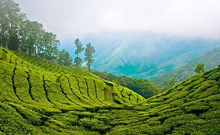
Strobilanthes kunthiana, known as Kurinji or Neelakurinji in Malayalam and Tamil and Gurige in Kannada is a shrub that is found in the shola forests of the Western Ghats in Kerala, Karnataka and Tamil Nadu. The purplish blue flower blossoms only once in 12 years, and gave the Nilgiri Mountains range its name, from the Malayalam language neela (blue) + Kurinji (flower). Of all long interval bloomers Strobilanthes kunthiana is the most rigorously demonstrated, with documented bloomings in 1838, 1850, 1862, 1874, 1886, 1898, 1910, 1922, 1934, 1946, 1958, 1970, 1982, 1994, 2006 and 2018, these have no match to Solar cycles.

Top Station is a tourist destination located in Theni district of Tamil nadu. Top Station is notable as the historic transshipment location for Kannan Devan tea delivered there from Munnar and Madupatty by railway and then down by ropeway to Kottagudi. This area is popular for the rare Neelakurinji flowers. The Kurinjimala Sanctuary is nearby. Top Station is the western entrance to the planned Palani Hills National Park.
The Palani Hills Wildlife Sanctuary and National Park is a proposed protected area in Dindigul District, Tamil Nadu India. The park will be an upgrade and expansion of the 736.87 km2(PRO) Palani (Kodaikanal) Wildlife Sanctuary which was to be established in 2008. The park includes about 36% of the 2,068 square kilometres (798 sq mi) in the Palani Hills. The park is located between latitude 10°7'–10°28' N and longitude 77°16'–77°46' E. Central location is 1.5 kilometres (0.93 mi) east northeast of Silver Cascade Waterfall and 4 kilometres (2.5 mi) E X NE of Kodaikanal Lake.
The Agasthyamala Biosphere Reserve is a biosphere reserve in India established in 2001, located in the southernmost end of the Western Ghats and includes 3,500.36 km2 (1,351.50 sq mi) of which 1828 km2 is in Kerala and 1672.36 km2 is in Tamil Nadu. It encompasses the following wildlife sanctuaries: Shendurney Wildlife Sanctuary, Peppara Wildlife Sanctuary, Neyyar Wildlife Sanctuary, and Kalakkad Mundanthurai Tiger Reserve.

Chinnar Wildlife Sanctuary is located 18 km north of Marayoor on State Highway 17 in the Marayoor and Kanthalloor panchayats of Devikulam taluk in the Idukki district of Kerala state in South India. It is one of 18 wildlife sanctuaries among the protected areas of Kerala.

Anamudi Shola National Park is a protected area located along the Western Ghats of Idukki district in Kerala state, India. It is composed of Mannavan shola, Idivara shola and Pullardi shola, covering a total area of around 7.5 km². Draft notification of this new park was released on 21 November 2003.

Pampadum Shola National Park is the smallest national park in Idukki district of Kerala in India. It is on the border with Dindigul district of Tamil Nadu. The park is administered by the Kerala Department of Forests and Wildlife, Munnar Wildlife Division, together with the nearby Mathikettan Shola National Park, Eravikulam National Park, Anamudi Shola National Park, Chinnar Wildlife Sanctuary and the Kurinjimala Sanctuary. The park adjoins the Allinagaram Reserved Forest within the proposed Palani Hills Wildlife Sanctuary and National Park.It is a part of Palani hills stretched up to Vandaravu peak. The Westerns Ghats, Anamalai Sub-Cluster, including these parks, is under consideration by the UNESCO World Heritage Committee for selection as a World Heritage Site.
Vattavada is a village in Idukki district in the state of Kerala, bordering Tamil Nadu, India.

Berijam Lake is a reservoir near Kodaikanal town in Dindigul district of Tamil Nadu, South India. It is at the old site of "Fort Hamilton", in the upper Palani hills. The lake, created by a dam with sluice outlets, is part of a micro–watershed development project. Periyakulam town, 18.7 kilometres (11.6 mi) to the SE, gets its public drinking water from the lake. The lake's water quality is excellent.

The Kodaikanal–Munnar Road was located in Dindigul District and Theni District of Tamil Nadu and Idukki district of Kerala in South India. It covers 81 kilometers (50 mi) from Kodaikanal to Munnar. The road was improved by the British in 1942 as an evacuation route in preparation for a possible Japanese invasion of South India. With a maximum elevation of 2,480 meters (8,140 ft) just south of Vandaravu Peak, it was among the highest roads in India, south of the Himalayas, prior to its closure in 1990.
Karian Shola National Park is a protected area in the Western Ghats, India, nominated as a national park in 1989. The Western Ghats are a chain of mountains running down the west of India parallel with the coast some 30 to 50 km inland. They are not true mountains, but the edge of a fault that resulted about 150 million years ago as the subcontinent of India split from Gondwanaland. They are older than the Himalayan mountain range and are clothed in ancient forests. They influence the weather in India as they intercept the incoming monsoon storm systems. The greatest rainfall occurs between June and September during the southwest monsoon, with lesser amounts falling in the northeast monsoon between October and November. The Western Ghats are a UNESCO World Heritage Site and are considered to be one of the eight most important "hotspots" of biological diversity in the world.