| Overbury | |
|---|---|
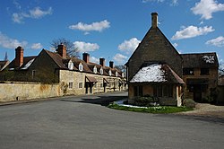 Cottages in Overbury | |
 Overbury Location within Worcestershire | |
| Population | 283 |
| OS grid reference | SO960377 |
| Civil parish |
|
| District | |
| Shire county | |
| Region | |
| Country | England |
| Sovereign state | United Kingdom |
| Post town | BREDON |
| Postcode district | GL20 |
| Police | West Mercia |
| Fire | Hereford and Worcester |
| Ambulance | West Midlands |
Overbury is a village and civil parish in Worcestershire, England, midway between Evesham and Tewkesbury south of Bredon Hill.
Contents
The manor of Overbury was purchased by the banking family of Martin in the 18th century from the Parsons family, members of whom also owned neighbouring Kemerton Court. The Martins rebuilt Overbury Court in c.1740, and it is still occupied by their descendants in 2018.
In 2014, Roman skeletons were found at Overbury Primary School when extensions to the school were being built. [1] [2]