| Croft Ambrey | |
|---|---|
| Aymestrey Near Leominster in UK | |
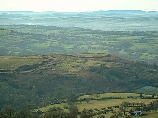
 Croft Ambrey at the north | |
| Area | 32 acres |
Croft Ambrey is an Iron Age hill fort in Herefordshire, England.
| Croft Ambrey | |
|---|---|
| Aymestrey Near Leominster in UK | |
| Croft Ambrey at the north | |
| Area | 32 acres |
Croft Ambrey is an Iron Age hill fort in Herefordshire, England.
Croft Ambrey, on Yatton Hill, is in the civil parish of Aymestrey, 6 miles (10 km) north from Leominster, 3.5 miles (6 km) south-east from the South Shropshire border, and approximately 7 miles (11 km) east from the Wales border. The fort is on high ground beyond and adjoining the north-east boundary of National Trust Croft Castle parkland. The nearest settlements are the villages of Yarpole, Aymestrey and Yatton, and the hamlet of Mortimer's Cross. [1] The Mortimer Trail waymarked long-distance footpath passes the site.

The monument includes a small multivallate hillfort with an annexe containing a Romano-Celtic temple and a medieval warren of up to five pillow mounds on the summit of a prominent steeply sloping spur overlooking Yatton Marsh and the valley of a tributary to Allcock's Brook. The hillfort survives as a roughly triangular enclosure defined to the north by two scarps with a buried ditch: to the west by three rampart banks and a larger internal ditch and to the south by three rampart banks with two medial ditches and a wide internal ditch which may have been used to store water. There were two complex entrances which through time had 20 successive gateposts and were further enhanced with guardrooms, corridors and bridges of which the south western was the principal entrance and the north eastern was complex and inturned. The enclosure originally covered approximately 2.2ha, but this increased through time to 3.6ha and eventually a southern rectangular annexe was added. This is defined by two slighter concentric banks. [2]
The hillfort was excavated between 1960 and 1966 and was found to have been in use from the 6th century BC up to AD 48. It contained closely set rectangular buildings which had been rebuilt up to six times. The population of the hillfort was estimated at 500-900 individuals. Finds included metalwork such as iron tools, weapons, sickles, blades, nails and a spade, shale and glass objects, bone and antler artefacts, spindle whorls, loom and thatch weights, saddle querns and rotary querns, hammer stones and Iron Age pottery.
There are some notable parallels with the hillfort at Wapley Hill, which also was used for rabbit farming.

Maiden Castle is an Iron Age hillfort 1.6 mi (2.6 km) southwest of Dorchester, in the English county of Dorset. Hill forts were fortified hill-top settlements constructed across Britain during the Iron Age.

Hod Hill is a large hill fort in the Blackmore Vale, 3 miles (5 km) north-west of Blandford Forum, Dorset, England. The fort sits on a 143 m (469 ft) chalk hill of the same name that lies between the adjacent Dorset Downs and Cranborne Chase. The hill fort at Hambledon Hill is just to the north. The name probably comes from Old English "hod", meaning a shelter, though "hod" could also mean "hood", referring to the shape of the hill.
Nordy Bank is an Iron Age hill fort on Brown Clee Hill in the Shropshire Hills Area of Outstanding Natural Beauty in South Shropshire, England.

Maiden Castle is an Iron Age hill fort, one of many fortified hill-top settlements constructed across Britain during the Iron Age, but one of only seven in the county of Cheshire in northern England. The hill fort was probably occupied from its construction in 600 BC until the Roman conquest of Britain in the 1st century AD. At this time the Cornovii tribe are recorded to have occupied parts of the surrounding area but, because they left no distinctive pottery or metalworking, their occupation has not been verified. Since then it has been quarried and used for military exercises. It is protected as a Scheduled Ancient Monument, and is owned by the National Trust. The hill fort is open to visitors, but unrestricted access to the site has resulted in it being classified as "at high risk" from erosion.

Burrough Hill is an Iron Age hillfort in Burrough on the Hill, 7 miles (11 km) south of Melton Mowbray in the English county of Leicestershire. Situated on a promontory about 210 metres (690 ft) above sea level, the site commands views over the surrounding countryside for miles around. There has been human activity in the area since at least the Mesolithic, and the hillfort was founded in the early Iron Age. In the medieval period, after the hillfort was abandoned, the hill was used as farmland. This ended in the 17th century when the parish the hill was in was enclosed. Traces of ridge and furrow show where the medieval fields were ploughed. Since the 1930s the site has been the subject of archaeological investigations and renewed excavations under the auspices of the University of Leicester began in 2010. Part of Burrough Hill Country Park and open to the public, the hillfort is protected as a Scheduled Ancient Monument.

Bury Camp is the site of an Iron Age multivallate hillfort in north-west Wiltshire, England. It occupies a triangular promontory of Colerne Down, in the north of Colerne parish, at the southern edge of the Cotswold Hills between two spurs of a river valley. The enclosed area of approximately 9.2ha is surrounded by a ditch 4m wide and up to 1m deep, and an outer rampart up to 1.5m high on the east and northwestern sides and up to 2m high on the southwestern side, across the neck of the promontory.
Hillforts in Britain refers to the various hillforts within the island of Great Britain. Although the earliest such constructs fitting this description come from the Neolithic British Isles, with a few also dating to later Bronze Age Britain, British hillforts were primarily constructed during the British Iron Age. Some of these were apparently abandoned in the southern areas that were a part of Roman Britain, although at the same time, those areas of northern Britain that remained free from Roman occupation saw an increase in their construction. Some hillforts were reused in the Early Middle Ages, and in some rarer cases, into the Later Medieval period as well. By the early modern period, these had essentially all been abandoned, with many being excavated by archaeologists in the nineteenth century onward.
Backwell Hillfort is an Iron Age hill fort situated approximately 1.1 miles (1.8 km) from Backwell in the North Somerset district of Somerset, England. The hill fort was first discovered in 1933 with two of the three sides of the fort protected by a large ditch and a bank. In 1956, the site was nearly completely destroyed by quarrying at Coles Quarry, which ceased production in the 1970's.
Ffridd Faldwyn is an Iron Age hillfort in northern Powys, in the former county of Montgomeryshire, It is sited on a prominent hill west of Montgomery, close to but higher than Montgomery Castle, overlooking the River Severn. It is one of the largest hill-forts in Wales.

Torberry Hill is an Iron Age hillfort in the county of West Sussex, in southern England. It is a Scheduled Ancient Monument, with a list entry identification number of 1015966. The hill fort is located within the parish of Harting, within the South Downs National Park. The hill includes the remains of an Early Iron Age univallate hill fort, a Middle Iron Age promontory fort and a post-medieval post mill. The hill is a chalk spur projecting northwards from the South Downs.
Beacon Hill, also known as Harting Beacon, is a hillfort on the South Downs, in the county of West Sussex in southern England. The hillfort is located in the parish of Elsted and Treyford, in Chichester District. It is a Scheduled Ancient Monument with a list entry identification number of 1015915. The hilltop enclosure is dated to the Late Bronze Age, from the 8th to 6th centuries BC. The hillfort defences were renewed during the Late Iron Age.
Holkham Camp, or Holkham Fort, is an Iron Age fort in Norfolk, England, about 1 mile (1.6 km) north-west of the village of Holkham. It is a scheduled monument.

Warbstow Bury is an Iron Age hillfort about 0.5 miles (0.8 km) west of the village of Warbstow, in Cornwall, England. It is a scheduled monument.

Chalbury Hillfort is an Iron Age hillfort about 1 mile (1.6 km) south-east of the village of Bincombe, in Dorset, England. It is a scheduled monument.
Bury Walls is an Iron Age hillfort about 1 mile (1.6 km) south-east of Weston-under-Redcastle, in Shropshire, England. It is a scheduled monument.

Jenny's Lantern is an area of moorland in north Northumberland, England, taking its name from an 18th-century 'eye-catcher' folly sited towards the top of a small promontory hill above the River Aln. Situated on the southern slope of the Jenny's Lantern area is an Iron Age hillfort, overbuilt by and adjoined to a larger and very well preserved Romano-British stone-built settlement and field system. It partially collapsed during a storm in November 2021.

Hollingbury Castle, also known as Hollingbury Camp and Hollingbury Hillfort, is an Iron Age hillfort on the northern edge of Brighton, in East Sussex, England. It is adjacent to Hollingbury Park Golf Course.

Yatton is a hamlet in the civil parish of Aymestrey in north-western Herefordshire, England. In 1870–72 the township had a population of 214.

Croft and Yarpole is a civil parish in the county of Herefordshire, England, and is 17 miles (27 km) north from the city and county town of Hereford. The closest large town is the market town of Leominster, 4.5 miles (7 km) to the south. Within the parish is the National Trust property of Croft Castle and Parkland.
Brandon Camp is an archaeological site, about 1 mile south of Leintwardine, in Herefordshire. England. It is a hillfort of the Iron Age, which later became a Roman fort. The site is a scheduled monument.
52°17′42″N2°48′54″W / 52.295°N 2.815°W
| | This Herefordshire location article is a stub. You can help Wikipedia by expanding it. |
| | This article about a Herefordshire building or structure is a stub. You can help Wikipedia by expanding it. |