
Maiden Castle is an Iron Age hillfort 1.6 mi (2.6 km) southwest of Dorchester, in the English county of Dorset. Hill forts were fortified hill-top settlements constructed across Britain during the Iron Age.

Danebury is an Iron Age hillfort in Hampshire, England, about 19 kilometres (12 mi) north-west of Winchester. The site, covering 5 hectares, was excavated by Barry Cunliffe in the 1970s. Danebury is considered a type-site for hill forts, and was important in developing the understanding of hillforts, as very few others have been so intensively excavated.

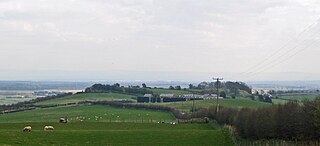
Hod Hill is a large hill fort in the Blackmore Vale, 3 miles (5 km) north-west of Blandford Forum, Dorset, England. The fort sits on a 143 m (469 ft) chalk hill of the same name that lies between the adjacent Dorset Downs and Cranborne Chase. The hill fort at Hambledon Hill is just to the north. The name probably comes from Old English "hod", meaning a shelter, though "hod" could also mean "hood", referring to the shape of the hill.

Maiden Castle is an Iron Age hill fort, one of many fortified hill-top settlements constructed across Britain during the Iron Age, but one of only seven in the county of Cheshire in northern England. The hill fort was probably occupied from its construction in 600 BC until the Roman conquest of Britain in the 1st century AD. At this time the Cornovii tribe are recorded to have occupied parts of the surrounding area but, because they left no distinctive pottery or metalworking, their occupation has not been verified. Since then it has been quarried and used for military exercises. It is protected as a Scheduled Ancient Monument, and is owned by the National Trust. The hill fort is open to visitors, but unrestricted access to the site has resulted in it being classified as "at high risk" from erosion.

Burrough Hill is an Iron Age hillfort in Burrough on the Hill, 7 miles (11 km) south of Melton Mowbray in the English county of Leicestershire. Situated on a promontory about 210 metres (690 ft) above sea level, the site commands views over the surrounding countryside for miles around. There has been human activity in the area since at least the Mesolithic, and the hillfort was founded in the early Iron Age. In the medieval period, after the hillfort was abandoned, the hill was used as farmland. This ended in the 17th century when the parish the hill was in was enclosed. Traces of ridge and furrow show where the medieval fields were ploughed. Since the 1930s the site has been the subject of archaeological investigations and renewed excavations under the auspices of the University of Leicester began in 2010. Part of Burrough Hill Country Park and open to the public, the hillfort is protected as a Scheduled Ancient Monument.
Eddisbury hill fort, also known as Castle Ditch, is an Iron Age hill fort near Delamere, Cheshire, in northern England. Hill forts are fortified hill-top settlements constructed across Britain during the Iron Age. Eddisbury is the largest and most complex of the seven hill forts in the county of Cheshire. It was constructed before 200–100 BC and expanded in 1–50 AD. In the 1st century AD, the Romans slighted the site. It was reoccupied in the 6th–8th centuries AD, and an Anglo-Saxon burh was probably established at Eddisbury in 914. In the medieval and post-medieval periods quarrying and farming have damaged the site. Ownership is currently split between the Forestry Commission and a local farm. Eddisbury is protected as a Scheduled Ancient Monument.
Oakmere hill fort is an Iron Age hill fort, one of many large fortified settlements constructed across Britain during the Iron Age, but one of only seven in the county of Cheshire in northern England. It is protected as a Scheduled Ancient Monument. Despite being a low-lying site, Oakmere is still considered a hill fort.

Buckland Rings is the site of an Iron Age hill fort in the town of Lymington, Hampshire. Today, the mounds and dykes around the outside which once constituted its defences are still clearly visible, although the outer bank lies under the road on the west side, and on the south-east it is nearly ploughed-out. Excavations of the inner and middle ramparts in 1935 revealed that they were of wall-and-fill construction, retained at the front by upright timber beams and walls of cut and laid turf. The entrance, which lies on the east side, was also excavated revealing a long entrance passage and the postholes for a pair of stout gateposts. The site was bought by Hampshire County Council in 1989 to ensure its preservation, and it is open to the public from the A337 road onto which part of it faces.

Blewburton Hill is the site of an Iron Age hillfort located in Oxfordshire, in the southeast of England. It was a univallate hillfort. The area is mostly farmland with some small areas of wooded copse to the south and the northeast. The hill fort may have been occupied from the 4th century BC to the 1st century BC, and replaced a small settlement surrounded by a stockade, which is estimated to have been built in the 5th or 6th century BC.

Scratchbury Camp is the site of an Iron Age univallate hillfort on Scratchbury Hill, overlooking the Wylye valley about 1 km northeast of the village of Norton Bavant in Wiltshire, England. The fort covers an area of 37 acres (15 ha) and occupies the summit of the hill on the edge of Salisbury Plain, with its four-sided shape largely following the natural contours of the hill.

Bratton Castle is a bivallate Iron Age built hill fort on Bratton Down, at the western edge of the Salisbury Plain escarpment. The hill fort comprises two circuits of ditch and bank which together enclose a pentagonal area of 9.3 hectares.
Castle Rings is a univallate hill fort in the parish of Donhead St Mary in Wiltshire, England. The site is a Scheduled Ancient Monument. Castle Rings has been dated to the Iron Age and is at an altitude of 228 metres (748 ft) upon Upper Greensand sandstone beds. The bulk of the fort enclosure lies within the boundaries of Donhead St Mary parish but some of the outlying earthworks are in the neighbouring Sedgehill and Semley parish. In the mid-1980s a metal detectorist unearthed a hoard of stater coins of the Durotriges tribe within the hill fort.

Chalbury Hillfort is an Iron Age hillfort about 1 mile (1.6 km) south-east of the village of Bincombe, in Dorset, England. It is a scheduled monument.
Berth Hill is an Iron Age hillfort in Staffordshire, England, about 5 miles (8.0 km) south-west of Newcastle-under-Lyme, and near the village of Maer. It is a scheduled monument. Other forms of its name have been Bryth, Bruff and Burgh Hill.

Banbury Hillfort, or Banbury Hill Camp, is an Iron Age hillfort, about 1.25 miles (2.0 km) south of Sturminster Newton and 1 mile (1.6 km) north-west of the village of Okeford Fitzpaine in Dorset, England.

Buzbury Rings is an Iron Age hillfort about 2 miles (3.2 km) east of Blandford Forum and 1 mile (1.6 km) northwest of the village of Tarrant Keyneston, in Dorset, England.

Caer Euni [Grid reference SJ 00027 41266] is an Iron Age hillfort, about 2.5 miles (4 km) north-east of the village of Llandderfel and about 5 miles (8 km) north-east of Bala Lake, in Gwynedd, Wales. It is a scheduled monument.

Maiden Bower is an Iron Age hillfort near Dunstable in Bedfordshire, England. The site, which also has traces of a Neolithic causewayed enclosure, is a scheduled monument.

Woodbury Hill is a hill near Bere Regis in Dorset, England. It is the site of an Iron Age hillfort, and the location of an annual fair from medieval times until the mid 20th century.
Brandon Camp is an archaeological site, about 1 mile south of Leintwardine, in Herefordshire. England. It is a hillfort of the Iron Age, which later became a Roman fort. The site is a scheduled monument.
