The South West Coast Path is England's longest waymarked long-distance footpath and a National Trail. It stretches for 630 miles (1,014 km), running from Minehead in Somerset, along the coasts of Devon and Cornwall, to Poole Harbour in Dorset. Because it rises and falls with every river mouth, it is also one of the more challenging trails. The total height climbed has been calculated to be 114,931 ft (35,031 m), almost four times the height of Mount Everest. It has been voted 'Britain's Best Walking route' twice in a row by readers of The Ramblers' Walk magazine, and regularly features in lists of the world's best walks.

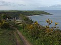
A promontory fort is a defensive structure located above a steep cliff, often only connected to the mainland by a small neck of land, thus using the topography to reduce the ramparts needed. Although their dating is problematic, most seem to date to the Iron Age. They are mainly found in Brittany, Ireland, the Orkney Islands, the Isle of Man, Devon, the Channel Islands and Cornwall.
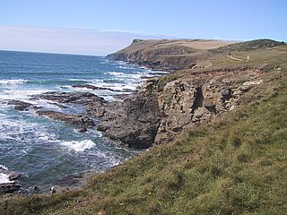
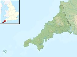
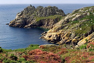
Pentire Head is a headland and peninsula on the Atlantic coast in North Cornwall, England, and is about one mile square. The headland projects north-west with Pentire Point at its north-west corner and The Rumps promontory at its north-east corner.

England comprises most of the central and southern two-thirds of the island of Great Britain, in addition to a number of small islands of which the largest is the Isle of Wight. England is bordered to the north by Scotland and to the west by Wales. It is closer to continental Europe than any other part of mainland Britain, divided from France only by a 33 km (21 mi) sea gap, the English Channel. The 50 km (31 mi) Channel Tunnel, near Folkestone, directly links England to mainland Europe. The English/French border is halfway along the tunnel.
Rame Head or Ram Head is a coastal headland, southwest of the village of Rame in southeast Cornwall, United Kingdom. It is part of the larger Rame Peninsula.
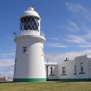
Pendeen Lighthouse, also known as Pendeen Watch is an active aid to navigation located 2 kilometres (1.2 mi) to the north of Pendeen in west Cornwall, England. It is located within the Aire Point to Carrick Du SSSI, the Cornwall Area of Outstanding Natural Beauty and the Penwith Heritage Coast. The South West Coast Path passes to the south.

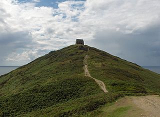
Hawker's Hut is an historic hut at Morwenstow, Cornwall originally built by the eccentric clergyman, poet and antiquarian, Robert Stephen Hawker, close to Higher Sharpnose Point. The hut is located approximately 1 mile from Morwenstow Church.
The Rumps is a twin-headland promontory at the north-east corner of Pentire Head in north Cornwall, United Kingdom.

Vault Beach is situated on the south coast of Cornwall, England, UK, near Gorran Haven. The beach consists mainly of shingle but does have some sand at low tide. Vault Beach faces southeast onto the English Channel and lies between Cadythew Rocks in the north and Dodman Point at the southern end.

Gurnard's Head is a prominent headland on the north coast of the Penwith peninsula in Cornwall, England. The name is supposed to reflect that the rocky peninsula resembles the head of the gurnard fish.
Treryn Dinas is a headland near Treen, on the Penwith peninsula between Penberth Cove and Porthcurno in Cornwall, England.
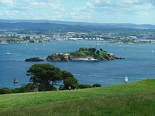
Mount Edgcumbe Country Park is listed as Grade I on the National Register of Historic Parks and Gardens and is one of four designated country parks in Cornwall, England, United Kingdom. The 885 acres (3.58 km2) country park is on the Rame Peninsula, overlooking Plymouth Sound and the River Tamar. The park has been famous since the 18th century, when the Edgcumbe family created formal gardens, temples, follies and woodlands around the Tudor house. Specimen trees, such as Sequoiadendron giganteum, stand against copses which shelter a herd of wild fallow deer. The South West Coast Path runs through the park for nine miles (14 km) along the coastline.
Stepper Point is a headland on the Atlantic coast in north Cornwall, England, United Kingdom. It is at grid reference SW911781. Stepper Point and Pentire Point stand at either side of the mouth of the River Camel; Stepper to the south-west, Pentire to the north-east.

The Church of St Morwenna and St John the Baptist is the parish church of Morwenstow, north Cornwall, England, United Kingdom, the most northerly parish in Cornwall. The church is dedicated to Morwenna, a local saint, and to John the Baptist, and is recorded in the National Heritage List for England as a designated Grade I listed building. It is an active Anglican parish church in the diocese of Truro, the archdeaconry of Bodmin, and the deanery of Stratton. Its benefice is combined with that of St James, Kilkhampton to form the United Benefice of Kilkhampton with Morwenstow.

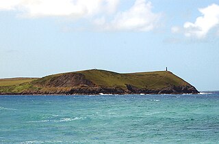
Gribbin Head is a promontory on the south coast of Cornwall, England, UK, owned and managed by the National Trust. It separates St Austell Bay from the estuary of the River Fowey and is marked by a large tower used to aid navigation of ships approaching the local harbours. The nearest town is Fowey. The western point of the headland is called Little Gribbin.

Trevaunance Cove is a small bay on the north Cornish coast and a residential area of St Agnes, Cornwall, United Kingdom. In the 18th and 19th centuries it was a busy harbour despite storms often destroying the quay. The South West Coast Path passes over the coastal slope to the north.

Zennor Head is a 750-metre (2,460 ft) long promontory on the Cornish coast of England, between Pendour Cove and Porthzennor Cove. Facing the Atlantic Ocean, it lies 1 kilometre north-west of the village of Zennor and 1.6 kilometres east of the next promontory, Gurnard's Head. The granite (Killas) cliffs rise over 200 feet (60 m) from the sea and the highest point of the headland is 314 feet (96 m) above sea level, with an Ordnance Survey triangulation station. Zennor Head is on the South West Coast Path, which follows the cliff edge closely, skirting the entire perimeter of the headland. The promontory is part of the Penwith Heritage Coast, and is the largest coastal feature in the United Kingdom that begins with the letter "Z". It gets its name from a local saint, Senara. Zennor Head was mined for copper and tin in the Victorian Era. There is no longer any residential or commercial occupancy on the headland, but it is occupied by a variety of coastal animals and plants, such as kestrels and gorse.

Cornish promontory forts, commonly known in Cornwall as cliff castles, are coastal equivalents of the hill forts and Cornish "rounds" found on Cornish hilltops and slopes. Similar coastal forts are found on the north–west European seaboard, in Normandy, Brittany and around the coastlines of the British Isles, especially in Wales, Scotland and Ireland. Many are known in southwest England, particularly in Cornwall and its neighbouring county, Devon. Two have been identified immediately west of Cornwall, in the Isles of Scilly.

Point Lookout Foreshore is a heritage-listed headland at East Coast Road, Point Lookout, City of Redland, Queensland, Australia. It is also known as Mooloomba. It was added to the Queensland Heritage Register on 27 August 2004.
Black Head is a headland at the western end of St Austell Bay, in Cornwall, England. It is owned by the National Trust.