The Tamar is a river in south west England, that forms most of the border between Devon and Cornwall. A part of the Tamar Valley is a World Heritage Site due to its historic mining activities.
Penwith is an area of Cornwall, United Kingdom, located on the peninsula of the same name. It is also the name of a former local government district, whose council was based in Penzance. The area is named after one of the ancient administrative hundreds of Cornwall which derives from two Cornish words, penn meaning 'headland' and wydh meaning 'at the end'.

The Longships is the name given to a group of rocky islets situated approximately 11⁄4 miles (2 km) west of Land's End, Cornwall, United Kingdom. The islets are marked by the Longships Lighthouse, the current structure being first lit in December 1873. The islets are very popular for recreational diving, the sea has clear water with prolific marine life and flora.

Porthcurno is a small village covering a small valley and beach on the south coast of Cornwall, England in the United Kingdom. It is the main settlement in a civil and an ecclesiastical parish, both named St Levan, which comprise Porthcurno, diminutive St Levan itself, Trethewey and Treen.

St Just, known as St Just in Penwith, is a town and civil parish in the Penwith district of Cornwall, England, United Kingdom. It lies along the B3306 road which connects St Ives to the A30 road. The parish encompasses the town of St Just and the nearby settlements of Trewellard, Pendeen and Kelynack: it is bounded by the parishes of Morvah to the north-east, Sancreed and Madron to the east, St Buryan and Sennen to the south and by the sea in the west. The parish consists of 7,622 acres (3,085 ha) of land, 12 acres (4.9 ha) of water and 117 acres (47.3 ha) of foreshore. The town of St Just is the most westerly town in mainland Britain and is situated approximately 8 miles (13 km) west of Penzance along the A3071. St Just parish, which includes Pendeen and the surrounding area, has a population of 4,637. An electoral ward of the same name also exists: the population of this ward at the same census was 4,812.
Pentire Head is a headland and peninsula on the Atlantic coast in North Cornwall, England, and is about one mile square. The headland projects north-west with Pentire Point at its north-west corner and The Rumps promontory at its north-east corner.

Priest Cove or Priest's Cove is a small cove one mile (1.6 km) west of St Just, Cornwall, UK. The name is from the Cornish Porth Ust, the port or cove of St Just, which was shortened to Por’ Ust. The apostrophised name "Priest’s" is a spelling mistake and the site has no connection with the clergy.

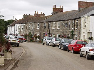
Pendeen is a village and ecclesiastical parish on the Penwith peninsula in Cornwall, United Kingdom. It is 3 miles north-northeast of St Just and 7 mi (11 km) west of Penzance. It lies along the B3306 road which connects St Ives to Land's End and the A30 road.

Drift Reservoir is a reservoir in Cornwall, England, UK, just north of the village of Drift and west of Penzance. The reservoir is 1,200 yards (1,100 m) long and covers 65 acres (26 ha). The dam is at the southern end of the reservoir, and the northern end, splits into north-western and north-eastern shallow arms. It is currently managed, jointly by the South West Lakes Trust and South West Water. There is public access to the dam and parking area only.

Boscaswell is a village in the extreme west of Cornwall, England, UK. It lies towards the cliffs from Pendeen, looking west across fields to the Atlantic Ocean. Boscaswell lies within the St Just in Penwith division of Cornwall Council. The village consists mainly of terraced cottages, built of granite, and a council house estate. Many of the cottages would once have housed families whose menfolk worked at the Geevor Tin Mine. Higher Boscaswell is a hamlet south-east of Pendeen.

The Botallack Mine is a former mine in Botallack in the west of Cornwall, UK. Since 2006 it has been part of the UNESCO World Heritage Site – Cornwall and West Devon Mining Landscape. The mine is within the Aire Point to Carrick Du Site of Special Scientific Interest (SSSI) and the South West Coast Path passes along the cliff.
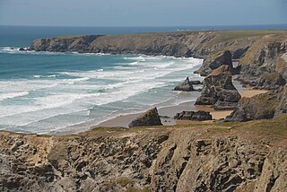
Carnewas and Bedruthan Steps is a stretch of coastline located on the north Cornish coast between Padstow and Newquay, in Cornwall, United Kingdom. It is within the parish of St Eval and is part-owned by the National Trust. The trust maintains a shop and café, and the cliff–top views of rocks stretching into the distance along Bedruthan beach make the area a popular attraction for tourists and painters. The property affords walks along the coast path and the steep steps at Bedruthan allow access to a series of rocky beaches at low tide. Signs at the top of the steps down to the beaches warn visitors not to risk swimming in these waters due to heavy rips, fast tides, and submerged rocks.

Mullion is a civil parish and village on the Lizard Peninsula in south Cornwall, England, United Kingdom. The nearest town is Helston approximately 5 miles (8 km) to the north.

Perranzabuloe is a coastal civil parish and a hamlet in Cornwall, England, United Kingdom. Perranzabuloe parish is bordered to the west by the Atlantic coast and St Agnes parish, to the north by Cubert parish, to the east by St Newlyn East and St Allen parishes and to the south by Kenwyn parish. The hamlet is situated just over a mile (2 km) south of the principal settlement of the parish, Perranporth; the hamlet is also seven miles (11 km) south-southwest of Newquay. Other settlements in the parish include Perrancoombe, Goonhavern, Mount and Callestick. The parish population was 5,382 in the 2001 census, increasing to 5,486 at the 2011 census.

Gurnard's Head is a prominent headland on the north coast of the Penwith peninsula in Cornwall, England, UK. The name is supposed to reflect that the rocky peninsula resembles the head of the gurnard fish.
Gwinear is a small village in west Cornwall, England, UK. It is about two miles (3 km) east of Hayle and overlooks the Angarrack valley. It is in the civil parish of Gwinear-Gwithian.

Penrose is a house and National Trust estate amounting to 1536 acres, east of Porthleven and in the civil parish of Sithney, Cornwall, England. The estate includes Loe Pool and Loe Bar which was given into the ownership of the National Trust in 1974 by Lt. Cdr. J. P. Rogers, and stretches along the coast to Gunwalloe. The estate was owned by the Penrose family for several hundred years before 1771 when it was bought for £11,000 by the Rogers family, whose descendants still reside in Penrose House.

Botallack is a village in west Cornwall, England, United Kingdom. It lies along the B3306 road which connects St Ives in the east to the A30 road, near Land's End. The village is included in the St Just in Penwith division on Cornwall Council. The original 1970s BBC television series Poldark was filmed partly in Botallack, using Manor Farm as Nampara. The Manor House, part of the Tregothnan estate, is a Grade II* listed building, dating from the 17th century.

Zennor Head is a 750-metre (2,460 ft) long promontory on the Cornish coast of England, between Pendour Cove and Porthzennor Cove. Facing the Atlantic Ocean, it lies 1 kilometre north-west of the village of Zennor and 1.6 kilometres east of the next promontory, Gurnard's Head. The granite (Killas) cliffs rise over 200 feet (60 m) from the sea and the highest point of the headland is 314 feet (96 m) above sea level, with an Ordnance Survey triangulation station. Zennor Head is on the South West Coast Path, which follows the cliff edge closely, skirting the entire perimeter of the headland. The promontory is part of the Penwith Heritage Coast, and is the largest coastal feature in the United Kingdom that begins with the letter "Z". It gets its name from a local saint, Senara. Zennor Head was mined for copper and tin in the Victorian Era. There is no longer any residential or commercial occupancy on the headland, but it is occupied by a variety of coastal animals and plants, such as kestrels and gorse.

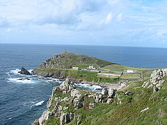
Cape Cornwall Mine was a tin mine on Cape Cornwall, a cape at the western tip of Cornwall, England, United Kingdom. It operated intermittently between 1838 and 1883, after which time it closed permanently and the engine house was demolished. The mine's 1864 chimney near the peak of the cape was retained as an aid to navigation, and in the early 20th century the former ore dressing floors were for a time converted into greenhouses and wineries. In 1987 the site was donated to the nation by the H. J. Heinz Company. The remains of Cape Cornwall Mine now form part of the Cornwall and West Devon Mining Landscape, a UNESCO World Heritage Site.