
Newquay is a town on the north coast in Cornwall, England, United Kingdom. It is a civil parish, seaside resort, regional centre for aerospace industries with a spaceport, and a fishing port on the North Atlantic coast of Cornwall, approximately 12 miles (19 km) north of Truro and 20 miles (32 km) west of Bodmin.
Porthtowan is a small village in Cornwall, England which is a popular summer tourist destination. Porthtowan is on Cornwall's north Atlantic coast about 2 km (1.2 mi) west of St Agnes, 4 km (2.5 mi) north of Redruth, 10 km (6.2 mi) west of Truro and 15 km (9.3 mi) southwest of Newquay in the Cornwall and West Devon Mining Landscape, a World Heritage Site.

St Columb Minor is a village on the north coast of Cornwall, England, United Kingdom.
The Rumps is a twin-headland promontory at the north-east corner of Pentire Head in north Cornwall, England, United Kingdom.

Towan is found in many placenames in Cornwall. However, The Towans usually refers to the three-mile (5 km) stretch of coastal dunes which extends north-east from the estuary of the River Hayle to Gwithian beach with a midpoint near Upton. The South West Coast Path crosses the towans.

Gurnard's Head is a prominent headland on the north coast of the Penwith peninsula in Cornwall, England. The name is supposed to reflect that the rocky peninsula resembles the head of the gurnard fish.

The Headland Hotel is a Grade II listed building located in Newquay, Cornwall, England, United Kingdom. It was opened in June 1900 and is built on a prominent position overlooking Fistral Beach and Towan Head.
The Truro and Newquay Railway was a Great Western Railway line in Cornwall, England, designed to keep the rival London and South Western Railway (LSWR) out of the west of the county. The line was completed in 1905 and closed in 1963.
Trevose Head is a headland on the Atlantic coast of north Cornwall, on the south-western coast of Great Britain. It is situated approximately 5 miles (8.0 km) west of Padstow. The South West Coast Path runs around the whole promontory and is within the Cornwall Area of Outstanding Natural Beauty and the Trevose Head Heritage Coast. In clear weather, visitors to Trevose Head can see virtually the whole length of the north Cornwall coast; to the north, the view extends beyond the Cornwall county boundary to Hartland Point, Devon; to the south, it extends beyond St Ives to the headland at Pendeen Watch.

St Ives Bay is a bay on the Atlantic coast of north-west Cornwall, England, United Kingdom. It is in the form of a shallow crescent, some 4 miles or 6 km across, between St Ives in the west and Godrevy Head in the east.
Polventon Bay, Mother Ivey's Bay is a bay and bathing beach on the north coast of Cornwall, United Kingdom. The bay is on east side of the headland, Trevose Head and within the parish of St Merryn. The South West Coast Path, which follows the coast of south-west England from Somerset to Dorset follows the cliff above the bay.

The River Allen in north Cornwall is one of two rivers in Cornwall which share this name. In this case the name is the result of a mistake made in 1888 by Ordnance Survey, replacing the name Layne with Allen which is the old name for the lower reaches of the Camel. The other River Allen runs through Truro.
The Cribbar, also known as the Widow Maker, is a reef off the Towan Headland in Newquay, Cornwall, England, United Kingdom.

St Austell Bay is a bay on Cornwall's south coast which is bounded to the east by Gribbin Head and to the west by Black Head.

Trenance is a hamlet adjoining Mawgan Porth in Cornwall, England, United Kingdom. Trenance Point is a headland nearby.
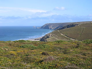
Presented below is an alphabetical index of articles related to Cornwall:

Newquay Central is an electoral division of Cornwall in the United Kingdom and returns one member to sit on Cornwall Council. The current Councillor is Geoff Brown, a Liberal Democrat and the Portfolio Holder for Transport on the council.

The Newquay Parish church of St Michael the Archangel, is located in Newquay, Cornwall, England, United Kingdom, and is dedicated to the St. Michael the Archangel. Since 1951 the church has been designated as a Grade II* listed building. It is an active Anglican parish church in the diocese of Truro, the archdeaconry of Cornwall and the deanery of Pydar.


