British Camp

Last updated

British Camp (left) Malvern Hills British Fort.jpg
British Camp (left)
The northern extension of British Camp Northern Extension to British Camp - geograph.org.uk - 519523.jpg
The northern extension of British Camp

British Camp is an Iron Age hill fort located at the top of Herefordshire Beacon in the Malvern Hills. The hill fort is protected as a Scheduled Ancient Monument and is owned and maintained by Malvern Hills Conservators. The fort is thought to have been first constructed in the 2nd century BC. A Norman castle was built on the site.

Contents

The extensive earthworks remain clearly visible today and determine the shape of the hill.

The height of the summit of British Camp is 1,109 feet (338 m). [1]

Situation

British Camp is composed of extensive earthworks that have been compared to a giant wedding cake. Midsummer Hill fort is a mile south of British Camp. There are a number of generally round hut platforms on British Camp, which may well suggest a permanent occupation. However it is unusual to have two major hill forts within such a short distance.

3D view of the digital terrain model British Camp Digital Terrain Model.jpg
3D view of the digital terrain model

The diarist John Evelyn (1620–1706) remarked that the view from the hill was "one of the godliest vistas in England". [2]

British Camp

The central earthworks British camp central mound 2005 (cropped).jpg
The central earthworks

The ditch and counterscarp bank around the entire site covers three hills, although those to north and south are little more than spurs. With a perimeter of 6,800 feet (2,100 m), the defences enclose an area of around 44 acres (18 ha). [3] The first earthworks were around the base of the central hill otherwise known as the citadel. At least four pre-historic phases of building have so far been identified. Original gates appear to have existed to east, west and north-east.

The Roman Era

There is no evidence about whether the coming of the Romans ended the prehistoric use of British Camp, but folklore states that the ancient British chieftain Caratacus made his last stand here. This is unlikely, according to the description of the Roman historian Tacitus who implies a site closer to the river Severn. Excavation at Midsummer Hill fort, Bredon Hill and Croft Ambrey all show evidence of violent destruction around 48 AD. This may suggest that British Camp was abandoned or destroyed around the same time.

The Castle

Medieval castles were sometimes built within earlier sites, reusing the earthworks of Iron Age hill forts for instance as was the case at British Camp. [4] A ringwork and bailey castle, known as Colwall Castle as well as The Herefordshire Beacon, was built within the Iron Age hill fort, [5] probably in the ten years immediately before 1066. Quite possibly the builder was Earl Harold Godwinson, the future King Harold II of England. Earl Harold is recorded as building another fortress in the county at Longtown Castle. The castle would appear to have been refortified during The Anarchy of the reign of King Stephen. Before 1148 the fortress was held by Waleran de Beaumont, 1st Earl of Worcester. The castle appears to have changed hands again in 1151 and 1153 when attacked by royalists. At this time it was defended by the men of Earl Waleran's brother, Robert de Beaumont, 2nd Earl of Leicester. The castle was finally destroyed by King Henry II in 1155 and mentioned in passing by William Langland before 1386.

The Shire Ditch

Along the Shire Ditch to Broad Down Along the Shire Ditch to Broad Down - geograph.org.uk - 1417378.jpg
Along the Shire Ditch to Broad Down

The Shire Ditch, or Red Earl's Dyke, runs north and south of British Camp along the ridge of the hills. It was created in 1287 by Gilbert de Clare, the Earl of Gloucester, following a boundary dispute with Thomas de Cantilupe, the Bishop of Hereford. [6] Recent research has shown that the Shire Ditch might actually be much older. Indeed, there is some evidence that it may have started life as a prehistoric trackway running from Midsummer Hill fort to the Worcestershire Beacon, the highest hill in the range over three miles to the north of the Camp.

Folklore

A popular legend tells that Caratacus, a British tribal chieftain, fought his last battle against the Romans at British Camp and goes on to say that after his capture he was taken to Rome where he was given a villa and a pension by Emperor Claudius.

However, the description by Tacitus, the Roman historian makes this unlikely:

Caratacus resorted to the ultimate hazard, adopting a place for battle so that entry, exit, everything would be unfavourable to us and for the better to his own men, with steep mountains all around, and, wherever a gentle access was possible, he strewed rocks in front in the manner of a rampart. And in front too there flowed a stream with an unsure ford, and companies of armed men had taken up position along the defences. [7]

Although the River Severn is visible from British Camp, it is about 8 kilometres (5 miles) from it, so this battle must have taken place elsewhere. A number of locations have been suggested, including sites near Brampton Bryan, an important Roman site, or Church Stretton which also has an Iron Age fort on Caer Caradoc Hill. [8]

Related Research Articles

<span class="mw-page-title-main">Worcestershire</span> County of England

Worcestershire is a ceremonial county in the West Midlands of England. It is bordered by Shropshire, Staffordshire, and the West Midlands county to the north, Warwickshire to the east, Gloucestershire to the south, and Herefordshire to the west. The city of Worcester is the largest settlement and the county town.

<span class="mw-page-title-main">Caratacus</span> 1st-century AD British chieftain of the Catuvellauni tribe

Caratacus was a 1st-century AD British chieftain of the Catuvellauni tribe, who resisted the Roman conquest of Britain.

<span class="mw-page-title-main">Malvern Hills</span> Hills in central England

The Malvern Hills are in the English counties of Worcestershire, Herefordshire and a small area of northern Gloucestershire, dominating the surrounding countryside and the towns and villages of the district of Malvern. The highest summit affords a panorama of the Severn Valley, the hills of Herefordshire and the Welsh mountains, parts of thirteen counties, the Bristol Channel, and the cathedrals of Worcester, Gloucester and Hereford.

<span class="mw-page-title-main">Malvern, Worcestershire</span> Spa town and civil parish in Worcestershire, England

Malvern is a spa town and civil parish in Worcestershire, England. It lies at the foot of the Malvern Hills, a designated Area of Outstanding Natural Beauty. The centre of Malvern, Great Malvern, is a historic conservation area, which grew dramatically in Victorian times due to the natural mineral water springs in the vicinity, including Malvern Water.

<span class="mw-page-title-main">Herefordshire</span> County of England

Herefordshire is a ceremonial county in the West Midlands region of England. It is bordered by Shropshire to the north, Worcestershire to the east, Gloucestershire to the south-east, and the Welsh counties of Monmouthshire and Powys to the west. The city of Hereford is the largest settlement and the county town.

The final battle in Caratacus' resistance to Roman rule was fought in 50 AD. The Romans under Publius Ostorius Scapula defeated the Britons and in the aftermath captured Caratacus himself, since 43 the leader of armed opposition to the Roman conquest of Britain. He was paraded through Rome and given the opportunity to make a speech before the emperor Claudius, who spared his life and those of his family and retainers.

<span class="mw-page-title-main">Worcestershire Beacon</span>

Worcestershire Beacon, also popularly known as Worcester Beacon, or locally simply as The Beacon, is a hill whose summit at 425 metres (1,394 ft) is the highest point in Worcestershire. It is part of the Malvern Hills which run about 13 kilometres (8.1 mi) north-south along the Herefordshire-Worcestershire border.

<span class="mw-page-title-main">Leintwardine</span> Human settlement in England

Leintwardine is a small to mid-size village and civil parish in north Herefordshire, England, close to the border with Shropshire.

Roger de Breteuil, 2nd Earl of Hereford, succeeded in 1071 to the earldom of Hereford and the English estate of his father, William Fitz-Osbern. He is known to history for his role in the Revolt of the Earls.

<span class="mw-page-title-main">Waleran de Beaumont, 1st Earl of Worcester</span> British Earl

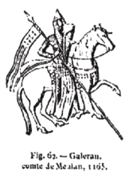
Waleran de Beaumont (1104–1166) was an Anglo-Norman nobleman. In his early adulthood, he was a member of the conspiracy of Amaury III of Montfort; later in his career, he participated in the Anarchy and the Second Crusade. During the reign of Henry II of England, Waleran's close ties to Louis VII of France caused him to fall out of grace.

<span class="mw-page-title-main">Herefordshire Beacon</span>

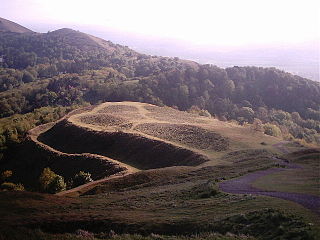
The Herefordshire Beacon is one of the highest peaks of the Malvern Hills. It is surrounded by a British Iron Age hill fort earthwork known as British Camp. The fort subsequently had a ringwork and bailey castle built inside its boundary and there is evidence of 120 huts in the area. British Camp has been a scheduled monument since 1923.

<span class="mw-page-title-main">Wigmore Abbey</span> Former religious house in Herefordshire

Wigmore Abbey was an abbey of Canons Regular with a grange, from 1179 to 1530, situated about a mile (2 km) north of the village of Wigmore, Herefordshire, England: grid reference SO 410713. Only ruins of the abbey now remain and on Historic England's Heritage at Risk Register their condition is listed as 'very bad'.

<span class="mw-page-title-main">Clifford Castle</span>

Clifford Castle is a ruined castle in the village of Clifford which lies 2.5 miles to the north-east of Hay-on-Wye in the Wye Valley in Herefordshire, England. It was the caput of the feudal barony of Clifford, a Marcher Lordship. The castle stands in the grounds of a private house and is only open to the public on certain days of the year.

<span class="mw-page-title-main">Huntington Castle</span> Castle in the United Kingdom

Huntington Castle was situated in the village of Huntington in Herefordshire, England, 2+12 miles south-west of Kington.

<span class="mw-page-title-main">Bernard de Neufmarché</span> 11th-century Norman nobleman in England

Bernard de Neufmarché, also Bernard of Newmarket or Bernard of Newmarch was the first of the Norman conquerors of Wales. He was a minor Norman lord who rose to power in the Welsh Marches before successfully undertaking the invasion and conquest of the Kingdom of Brycheiniog between 1088 and 1095. Out of the ruins of the Welsh kingdom he created the Anglo-Norman lordship of Brecon.

Stapleton is a small village and civil parish in Herefordshire near the border town of Presteigne in Wales. The parish borders on Willey, Kinsham and Presteigne. Stapleton is surrounded by farmland. Bryan's Ground gardens are open to the public.

Ewyas was a possible early Welsh kingdom which may have been formed around the time of the Roman withdrawal from Britain in the 5th century. The name was later used for a much smaller commote or administrative sub-division, which covered the area of the modern Vale of Ewyas and a larger area to the east including the villages of Ewyas Harold and Ewyas Lacy.

<span class="mw-page-title-main">Malvern Museum</span> Museum in Malvern, Worcestershire, England

The Malvern Museum in Great Malvern, the town centre of Malvern, Worcestershire, England, is located in the Priory Gatehouse, the former gateway to the Great Malvern Priory. The museum was established in 1979 and is owned and managed by the Malvern Museum Society Ltd, a registered charity. The Priory Gatehouse was a gift to the museum in 1980 from the de Vere Group, the owners of the neighbouring Abbey Hotel, and is staffed by volunteers. As such, the building itself is the museum's major exhibit.

<span class="mw-page-title-main">Midsummer Hill</span>

Midsummer Hill is situated in the range of Malvern Hills that runs approximately 13 kilometres (8 mi) north-south along the Herefordshire-Worcestershire border. It lies to the south of Herefordshire Beacon with views to Eastnor Castle. It has an elevation of 284 metres (932 ft). To the north is Swinyard Hill. It is the site of an Iron Age hill fort which spans Midsummer Hill and Hollybush Hill. The hillfort is protected as a Scheduled Ancient Monument and is owned by Natural England. It can be accessed via a footpath which leads south from the car park at British Camp on the A449 or a footpath which heads north from the car park in Hollybush on the A438.

<span class="mw-page-title-main">Castle Frome</span> Human settlement in England

Castle Frome is a village and civil parish in the county of Herefordshire, England, and is 10 miles (16 km) north-east from the city and county town of Hereford. The closest large town is the market town of Bromyard, 5 miles (8 km) to the north. The Norman font in Castle Frome church is "one of the outstanding works of the Herefordshire school".

References

Notes
  1. "Herefordshire Beacon/". Peakery. Retrieved 9 August 2015.
  2. Smart 2009 , p. 15
  3. Price 1881 , p. 323
  4. Higham & Barker 1992 , p. 61
  5. King 1983 , p. 204
  6. Palmer, R. 1992, The Folklore of Hereford and Worcester. Oxford University Press
  7. Tacitus, The Annals, translated by A. J. Woodman, 2004; see also Church & Brodribb's translation
  8. "Megalithic site" . Retrieved 20 May 2009.
Bibliography

Further reading

52°03′29″N2°21′06″W / 52.05798°N 2.35176°W / 52.05798; -2.35176