
The River Avon is in the south of England, rising in Wiltshire, flowing through that county's city of Salisbury and then west Hampshire, before reaching the English Channel through Christchurch Harbour in the Bournemouth, Christchurch and Poole conurbation of Dorset.

Fordingbridge is a town and broader civil parish with a population of 6,000 on the River Avon in the New Forest District of Hampshire, England, near the Dorset and Wiltshire borders and on the edge of the New Forest, famed for its late medieval seven-arch bridge.
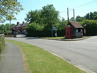
Woodgreen is a village and civil parish within the New Forest district of Hampshire in England.

Breamore is a village and civil parish near Fordingbridge in Hampshire, England. The parish includes a notable Elizabethan country house, Breamore House, built with an E-shaped ground plan. The Church of England parish church of Saint Mary has an Anglo-Saxon rood.

Godshill is a village and civil parish and in New Forest National Park in Hampshire, England. It is about 1+1⁄2 miles (2.4 km) east of the town of Fordingbridge and 10 miles (16 km) south of the city of Salisbury.

Damerham is a rural village and civil parish in the New Forest district of Hampshire, England, near Fordingbridge. The area has notable Neolithic and Bronze Age barrows. It was the site of an Anglo-Saxon religious community, mentioned in the will of Alfred the Great. By the time of Domesday Book (1086), Damerham was a major settlement in the possession of Glastonbury Abbey. The village has a riverside mill and a Norman church.

Martin is a village and civil parish in the New Forest district of Hampshire, England. The nearest town, Fordingbridge, is 7 miles (11 km) to the south-east, and the cathedral city of Salisbury is 12 miles (19 km) to the north-east.

Hale is a small village and civil parish in Hampshire, England. It lies on the border of the New Forest, overlooking the valley of the River Avon. The village is about 3.5 miles (5.6 km) north-east of the town of Fordingbridge, and about 8 miles (13 km) south of the city of Salisbury. Within the parish stands Hale House, a large 18th-century mansion which was the country house of architect Thomas Archer, who also rebuilt Hale church in 1717.

Fordingbridge was a railway station serving Fordingbridge, a small town in Hampshire. It was one of many casualties of the mass closure of British railway lines in the 1960s and 1970s. The line was officially closed on 4 May 1964, but as there was no Sunday service the last trains ran on the 2nd. It was served by the Salisbury and Dorset Junction Railway, a line running north–south, along the River Avon just to the west of the New Forest, connecting Salisbury to the North and Poole to the south, meeting the Southampton and Dorchester Railway at West Moors.
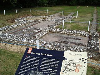
Rockbourne Roman Villa is a Roman courtyard villa excavated and put on public display in the village of Rockbourne in the English county of Hampshire. The villa was discovered in 1942 by a local farmer and excavated by A. T. Morley Hewitt over the next thirty years.

Ibsley is a village and former civil parish, now in the parish of Ellingham, Harbridge and Ibsley, in the New Forest district, in Hampshire, England. It is about 2.5 miles (4 km) north of the town of Ringwood. In 1931 the parish had a population of 228.

Buckland Rings is the site of an Iron Age hill fort in the town of Lymington, Hampshire. Today, the mounds and dykes around the outside which once constituted its defences are still clearly visible, although the outer bank lies under the road on the west side, and on the south-east it is nearly ploughed-out. Excavations of the inner and middle ramparts in 1935 revealed that they were of wall-and-fill construction, retained at the front by upright timber beams and walls of cut and laid turf. The entrance, which lies on the east side, was also excavated revealing a long entrance passage and the postholes for a pair of stout gateposts. The site was bought by Hampshire County Council in 1989 to ensure its preservation, and it is open to the public from the A337 road onto which part of it faces.
Burgate is a hamlet situated on the western edge of the New Forest National Park in Hampshire, England. The hamlet is situated on the A338 road. The nearest town is Fordingbridge, which lies approximately 0.5 miles (1 km) to the southwest.

Gorley Hill is the site of a former Iron Age promontory hillfort located in Hampshire in the United Kingdom.
Lockerley Camp is the site of an Iron Age univallate hillfort located in Hampshire. Situated on a low gravel-capped plateau, it covers approximately 5 acres and is now much reduced by ploughing, for the majority of the site falls into farmland, although a small area to the north is within a small coppice and the earthworks are more discernible here.

Norsebury Ring is the site of an Iron Age univallate hillfort located in Hampshire. Now mostly ploughed out to the South and east, some ditches and ramparts remain within a small copsed area to the North and west, which are surprisingly intact with a small outer ditch, then a bank, then another larger ditch followed by larger bank. However the trees and undergrowth hide the earthworks from immediate view.

Tidbury Ring is the site of an Iron Age univallate hillfort located in Hampshire. The earthworks have been heavily destroyed by ploughing, but some sections to the south remain in better condition. The entrance lies to the southeast of the fort. The interior is for the most part farmland with the earthworks now covered by small trees and undergrowth Two Roman buildings, possibly a courtyard villa complex were found within the hill-fort. The site is now listed as a scheduled ancient monument no.87

Woolbury, or Woolbury Ring, is the site of an Iron Age univallate hill fort on Stockbridge Down, Hampshire, England.
North Gorley is a hamlet in the New Forest National Park of Hampshire, England. Its nearest town is Fordingbridge, which lies approximately 2 miles (3.2 km) north of the hamlet.

Stuckton is a hamlet in the New Forest National Park of Hampshire, England. Its nearest town is Fordingbridge, which lies approximately 1 mile (1.7 km) north-west from the village.


