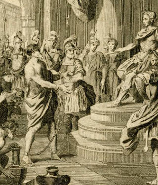
Caratacus was a 1st-century AD British chieftain of the Catuvellauni tribe, who resisted the Roman conquest of Britain.
The Silures were a powerful and warlike tribe or tribal confederation of ancient Britain, occupying what is now south east Wales and perhaps some adjoining areas. They were bordered to the north by the Ordovices; to the east by the Dobunni; and to the west by the Demetae.

Church Stretton is a market town and civil parish in Shropshire, England, 13 miles (21 km) south of Shrewsbury and 15 miles (24 km) north of Ludlow. The population in 2011 was 4,671.
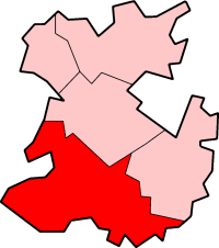
South Shropshire was a local government district in Shropshire, England, from 1974 to 2009. Its council was based in the town of Ludlow; the other towns in the district were Church Stretton, Cleobury Mortimer, Clun, Bishop's Castle and Craven Arms.

The Wrekin is a hill in east Shropshire, England. It is located some five miles (8 km) west of Telford, on the border between the unitary authorities of Shropshire and Telford and Wrekin. Rising above the Shropshire Plain to a height of 407 metres (1,335 ft) above sea level, it is a prominent and well-known landmark, signalling the entrance to Shropshire for travellers westbound on the M54 motorway. The Wrekin is contained within the northern salient of the Shropshire Hills AONB. The hill is popular with walkers and tourists and offers good views of Shropshire. It can be seen well into Staffordshire and the Black Country, and even as far as the Beetham Tower in Manchester, Winter Hill in Lancashire and Cleeve Hill in Gloucestershire.

The Long Mynd is a heath and moorland plateau that forms part of the Shropshire Hills in Shropshire, England. The high ground, which is common land and designated as an Area of Outstanding Natural Beauty, lies between the Stiperstones range to the west and the Stretton Hills and Wenlock Edge to the east. Much of it is owned by the National Trust, and is managed by the Longmynd Commoners.
The Shropshire Hills National Landscape is a designated Area of Outstanding Natural Beauty (AONB) in Shropshire, England. It is located in the south of the county, extending to its border with Wales. Designated in 1958, the area encompasses 802 square kilometres (310 sq mi) of land primarily in south-west Shropshire, taking its name from the upland region of the Shropshire Hills. The A49 road and Welsh Marches Railway Line bisect the area north–south, passing through or near Shrewsbury, Church Stretton, Craven Arms and Ludlow.
The geology of the county of Shropshire, England is very diverse with a large number of periods being represented at outcrop. The bedrock consists principally of sedimentary rocks of Palaeozoic and Mesozoic age, surrounding restricted areas of Precambrian metasedimentary and metavolcanic rocks. The county hosts in its Quaternary deposits and landforms, a significant record of recent glaciation. The exploitation of the Coal Measures and other Carboniferous age strata in the Ironbridge area made it one of the birthplaces of the Industrial Revolution. There is also a large amount of mineral wealth in the county, including lead and baryte. Quarrying is still active, with limestone for cement manufacture and concrete aggregate, sandstone, greywacke and dolerite for road aggregate, and sand and gravel for aggregate and drainage filters. Groundwater is an equally important economic resource.
Corndon Hill is a hill in Powys, Mid Wales, whose summit rises to 513.6 metres (1,685 ft) above sea level. It has a topographic prominence of 203.1 metres (666 ft), so is listed as a Marilyn.
Caradog, Caradoc, Caradawg, or Cradawg, Latinised as Caratacus and anglicised as Craddock, is a given name for men in the Welsh language. It may refer to:

The Shropshire Hills are a dissected upland area and one of the natural regions of England. They lie wholly within the county of Shropshire and encompass several distinctive and well-known landmarks, such as the Long Mynd, Wenlock Edge, The Wrekin and the Clees.

British Camp is an Iron Age hill fort located at the top of Herefordshire Beacon in the Malvern Hills. The hill fort is protected as a Scheduled Ancient Monument and is owned and maintained by Malvern Hills Conservators. The fort is thought to have been first constructed in the 2nd century BC. A Norman castle was built on the site.

Breidden Hill is a steep-sided hill in Powys, Wales, near the town of Welshpool. It is immediately surrounded by the villages of Trewern, Middletown, Criggion, Crew Green and Llandrinio. The peak of the hill reaches to 367 metres (1,204 ft). Footpaths which lead up to the summit provide excellent 360 degree views over Powys and over the border with England to the Shropshire Plain.

Wild Edric's Way is a waymarked long distance footpath running wholly within the county of Shropshire in England. The path runs for 49 miles (79 km), mostly sharing the route of the Shropshire Way.

Chapel Lawn is a small village in southwest Shropshire, England, located within the Redlake Valley, some three miles south of the small town of Clun.

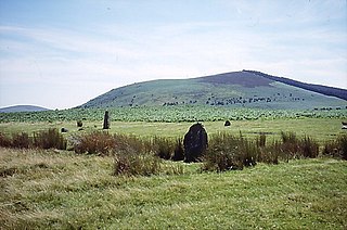
Bury Ditches is a British Iron Age hill fort between Clun and Bishop's Castle in the Shropshire Hills of central England.
Croft Ambrey is an Iron Age hill fort in Herefordshire, England.

Leebotwood is a small village and civil parish in Shropshire, England. It is about 9 miles (14 km) south of Shrewsbury and 3.5 miles (5.6 km) north of Church Stretton.
Uriconian rocks are volcanic rocks found in parts of Shropshire, United Kingdom. The name relates to Uriconio, the Latin name for an Iron Age hillfort on the summit of the Wrekin, a hill formed of Uriconian rock.

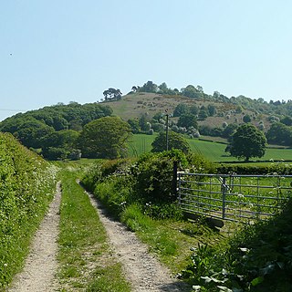
Caer Caradoc (Chapel Lawn) (Welsh – Caer Caradog) is an Iron Age hill fort and Scheduled Monument in the south-west of the English county of Shropshire, near the town of Clun. It overlooks the village of Chapel Lawn. It is located within an area of Open Access land and can be reached via a public footpath between the farms of Wax Hall to the west and Bryncambric to the east.


