Bucknell is a village and civil parish in south Shropshire, England. The village lies on the River Redlake, within 660 yards (600 m) of the River Teme and close to the border of Wales and Herefordshire. It is about 6 miles (9.7 km) east of Knighton and is set within the Shropshire Hills Area of Outstanding Natural Beauty.
The name is derived from Old English and means 'Bucca's hill' or 'he-goats' hill'. [2]
The village has the "P"s identified by Country Life as essential to a successful village: a pub, a post office, a place of worship, a primary school and public transport. [3]
The settlement of Bucknell was first mentioned in the Domesday Book of 1086, as Buckehale or Buckenhill. At the time of the Domesday survey, the Shropshire and Herefordshire boundary divided the village. The Norman magnate Roger de Montgomery held the village from the King. He built many castles including Montgomery, Shrewsbury, Ludlow, Clun, Hopton and Oswestry; at the time over 90 per cent of the lordships and manors of Shropshire were held in Chief by him. His under-tenants in this area were Ralph de Mortimer, who held Bucknell (amongst his 123 manors with his chief domain in England being at Wigmore Castle), and William de Picot (also known as Picot de Say), with his chief domain at Clun Castle.
The earth mound at The Olde Farm in Bucknell is the remains of a Norman motte castle situated on the banks of the River Redlake, close to a river crossing point and to the Parish Church. In 1554–55 an Act of Parliament was passed transferring the whole of Bucknell to the county of Shropshire. The Lords of the Manor at that time were the Sitwell family.
Historically, most of the male population worked in agriculture and timber.
The earliest of the existing buildings date back to the 17th century. The houses were built in a haphazard fashion near the river with easy access to water. The village depended on water from the river and wells until the 1920s when water was piped into the village from a spring above Chapel Lawn. The houses at the lower end of the village were very susceptible to flooding, and this hazard continued until the ford was walled up in the 1950s.
Bucknell had four pubs: The Sitwell Arms, The Plough (just opposite), The Railway Tavern and The Bridge End. The latter three are all now private houses, though a new pub, the Baron of Beef, is now open. Bucknell also had a shop and bakery in the Square and its own corn mill which was at the west end of the village. Bucknell Post office opened in the mid-19th century. The original post office was just round the corner and still goes by the name of The Old Post Office. The butcher's shop is still on its original site.
After World War I a Memorial Hall was built in the village, originally from a mess hut removed from a Canadian Army camp, and still stands. It contains plaques in memory of men from the parish who died serving in the World Wars. [4] One of those behind its construction was William Burgoyne.
Today the village boasts an impressive number of businesses and public services for its size: two public houses, a post office, a butcher, a petrol forecourt and shop, a general store open every day, a railway station, a primary school and numerous companies providing services to local agricultural and forestry enterprises.
The Old School House was built in the 16th century, this part being the part of the building next to the river to provide education for those who could pay for it. The school remained until the present one was built in 1865. The Old School House then became a shop and bakers before becoming a private dwelling. The front part of the building pre-dates the rear by around 200 years making it 13th/14th century and whilst being restored was found to have once existed as a ground floor-only property and evidence of an open fire pit and an opening in the roof to allow the smoke to escape; this pre-dates the inglenook fireplace to the rear and was believed to have been a medieval great hall. Restoration was completed in 1999.
The land upon which the present school was built was given in 1865. The first schoolmaster appointed in 1867 to the new St Mary's National School was Mr Henry Evans, 24 years old. The school was extensively re-modelled in 1966 when additional teaching space and a kitchen was added enabling meals to be cooked on the premises. St Mary's school [5] is a maintained Church of England primary school with 43 pupils on roll at January 2004. The age range is 4–11 years.
An independent school, Bedstone College, is also nearby. [6]
Despite more houses, the number of people living in Bucknell has dropped. The population of the village in 1811 Census was 226. At the end of the 19th century this had risen to 546. In the 1981 Census the population of the village was 494; in 1991 the population of the parish (probably including Bedstone) was 601 consisting of some 250 dwellings and in 2001 it was 642 in 294 dwellings. [8]
The village has a railway station on the Heart of Wales Line. There are nine trains a day on weekdays and eight on Saturdays, five/four to Shrewsbury and four to Swansea (plus two each way on Sundays). [9] There is also a bus service to Knighton and Ludlow.
An association football club exists in the village—called Bucknell F.C.— who previously played in the Mid Wales South League (despite being based in England they currently play in the Welsh football league system). [10] They played in the Herefordshire Football League in the 2010–11 season (and before that in the Mid Wales South League as now). Bucknell play at the Daffodil Lane Recreation Ground. Another Shropshire village, also in the southwest of Shropshire, have a team playing in the same league: Newcastle.
Bishop's Castle is a market town in the south west of Shropshire, England. According to the 2011 Census it had a population of 1,893.
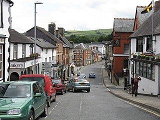
Knighton is a market town and community on the River Teme, straddling the border between Powys, Wales and Shropshire, England. It lies in the traditional county of Radnorshire. Originally an Anglo-Saxon settlement, Knighton is located on Offa's Dyke, the ancient earthwork that divided the two countries. It later became a Norman defensive border town.
Clun is a town in south west Shropshire, England, and the Shropshire Hills Area of Outstanding Natural Beauty. The 2011 census recorded 680 people living in the town. Research by the Campaign for the Protection of Rural England suggests that Clun is one of the "most tranquil" locations in England.
Hopton Heath, or Hoptonheath, is a hamlet in south Shropshire, England. The border with Herefordshire is close by. It lies on the border of the civil parishes of Clungunford and Hopton Castle.
Bedstone is a small village and civil parish in south Shropshire, England, close to the border with Herefordshire.
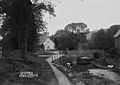
Newcastle is a village in the rural south west of Shropshire, England. It lies at the confluence of the River Clun and the Folly Brook, 3 miles west of the small town of Clun. The B4368 runs through the village, on its way between Craven Arms in Shropshire to Newtown in Powys.
Clungunford is a village and civil parish in south Shropshire, England, located near the border with Herefordshire.
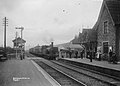
The Shropshire Hills National Landscape is a designated Area of Outstanding Natural Beauty (AONB) in Shropshire, England. It is located in the south of the county, extending to its border with Wales. Designated in 1958, the area encompasses 802 square kilometres (310 sq mi) of land primarily in south-west Shropshire, taking its name from the upland region of the Shropshire Hills. The A49 road and Welsh Marches Railway Line bisect the area north–south, passing through or near Shrewsbury, Church Stretton, Craven Arms and Ludlow.
Leintwardine is a small to mid-size village and civil parish in north Herefordshire, England, close to the border with Shropshire.
Abcott is a hamlet in south Shropshire, England.
Buckton and Coxall is a civil parish in north Herefordshire, England.
Hopesay is a small village, and civil parish, in south Shropshire, England. The population of the parish at the 2011 census was 561.
Brampton Bryan is a small village and civil parish situated in north Herefordshire, England close to the Shropshire and Welsh borders.
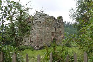
Hopton Castle is a small village and civil parish in south Shropshire, England.
Chapel Lawn is a small village in southwest Shropshire, England, located within the Redlake Valley, some three miles south of the small town of Clun.
Broadward is a dispersed hamlet in south Shropshire, England, situated by the border with Herefordshire. It is in the civil parish of Clungunford, a village approximately 2 miles (3.2 km) to the north.
Jay is a hamlet located in north Herefordshire, England.
Heath is a dispersed hamlet in north Herefordshire, England.
The Redlake is a minor river in southwest Shropshire, England.