
Basingstoke is the largest town in the county of Hampshire. It is situated in south-central England and lies across a valley at the source of the River Loddon, at the far western edge of The North Downs. It is located 30 miles (48 km) north-east of Southampton, 48 miles (77 km) south-west of London, 27 miles (43 km) west of Guildford, 22 miles (35 km) south of Reading and 20 miles (32 km) north-east of the county town and former capital Winchester. According to the 2016 population estimate, the town had a population of 113,776. It is part of the borough of Basingstoke and Deane and part of the parliamentary constituency of Basingstoke.
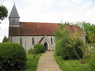
Exton is a small village and civil parish in the City of Winchester district of Hampshire, England. The village lies in the South Downs National Park, on the west bank of the River Meon, immediately to the north of Corhampton. It is located two miles north of Droxford and five miles north-east of Bishop's Waltham. Its name first appears in 940 as East Seaxnatune, meaning "farmstead of the East Saxons".

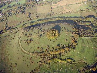
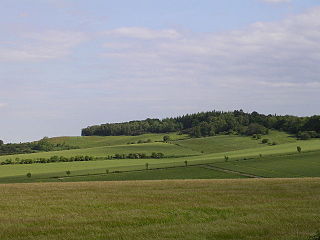
Beacon Hill is near the village of Burghclere and Watership Down, in north Hampshire. The hill's name is derived from the fact that it was one of many Beacon Hills in England and beyond. This hill was once the site of the most famous beacon in Hampshire. It is 261 metres high and has one of England's most well known hill forts on its slopes, visible from the main A34 road which passes close by. From there, outstanding views of the surrounding area and much of Hampshire may be obtained. The site is open to the public and managed by Hampshire County Council. It is an 80.7-hectare (199-acre) biological Site of Special Scientific Interest called Burghclere Beacon and a Nature Conservation Review site, Grade I.
Whitsbury is a village and civil parish in Hampshire, England, close to Fordingbridge. Whitsbury is a part of a group of villages on the edge of the Cranborne Chase and West Wiltshire Downs Area of Outstanding Natural Beauty.
St. Catherine's Hill is a chalk downland hill and 43-hectare (110-acre) biological Site of Special Scientific Interest on the outskirts of Winchester in Hampshire. It is owned by Winchester College but open to the public. It is managed by Hampshire and Isle of Wight Wildlife Trust, and most of it is an Iron Age hillfort, which is a Scheduled Monument.

Netley Marsh is a village and civil parish in Hampshire, close to the town of Totton. It lies within the New Forest District, and the New Forest National Park. It is the alleged site of the battle between an invading Anglo Saxon army, under Cerdic and a British army under Natanleod in the year 508.

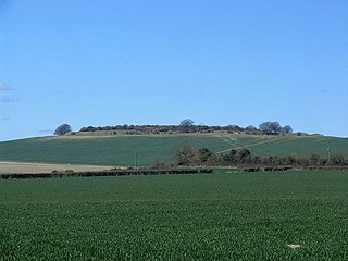
Ladle Hill is a 10.5-hectare (26-acre) biological Site of Special Scientific Interest west of Kingsclere in Hampshire. It is also a Scheduled Monument.

Castle Hill is the site of an Iron Age univailate hillfort located in the civil parish of Burley in the New Forest national park in Hampshire, England. Its single rampart and ditch earthworks enclose approximately five acres of land and is in reasonable condition for the most part, although it is cut through by tracks leading to local houses. Parts of the interior are marshy and much of it is overgrown with oak, silver birch, holly and bracken. The bank is at its highest on the eastern side, as the west side slopes steeply away. Hampshire treasures lists the site as a Scheduled Ancient Monument. According to legend, the hill apparently was once the home to a local dragon, duly slain by a knight from the nearby village of Brook; and thus the local pub at Brook bears the name of the Green Dragon.
Frankenbury Camp is the site of an Iron Age univallate hillfort located in Hampshire. The site is on a very slight promontory overlooking the Avon Valley on the north-western edge of the New Forest. The fort encloses approximately 11 acres. It has very steep natural slopes on the west and south sides. The northeast sides are defended by a simple rampart and ditch. The original entrance on the southeast corner has since been widened. It is listed as a scheduled ancient monument no.122. The site is currently pasture, and part of Folds Farm, for the most part, although the earthworks themselves are lined with trees and the south and western parts are now encroached by woodland. Various archaeological relics have been found in the area:

Gorley Hill is the site of a former Iron Age promontory hillfort located in Hampshire in the United Kingdom.
Knoll Camp, or Damerham Knoll, is the site of an Iron Age univallate hill fort located in Hampshire. The fort comprises a circular earthwork containing about four acres. There is a single ditch with inner rampart and traces of counter scarp bank. The site is a scheduled ancient monument no.118. Grim's Ditch also runs throughout this area. The footpath/bridleway from the nearby long barrows of Grans Barrow and Knap Barrow runs southeast along the ridge through the centre of the hill fort, leaving through the original SE entrance, and you could easily miss the ditch and bank as you cross it. The interior is thickly wooded and brambled.

Norsebury Ring is the site of an Iron Age univallate hillfort located in Hampshire. Now mostly ploughed out to the South and east, some ditches and ramparts remain within a small copsed area to the North and west, which are surprisingly intact with a small outer ditch, then a bank, then another larger ditch followed by larger bank. However the trees and undergrowth hide the earthworks from immediate view.
Quarley Hill is the site of an Iron Age univallate hill fort in Hampshire, southern England. The hill affords commanding views of the surrounding countryside.

Tidbury Ring is the site of an Iron Age univallate hillfort located in Hampshire. The earthworks have been heavily destroyed by ploughing, but some sections to the south remain in better condition. The entrance lies to the southeast of the fort. The interior is for the most part farmland with the earthworks now covered by small trees and undergrowth Two Roman buildings, possibly a courtyard villa complex were found within the hill-fort. The site is now listed as a scheduled ancient monument no.87

Whitsbury Castle, or Whitsbury Castle Ditches, is the site of an Iron Age univallate hillfort located near the village of Whitsbury in Hampshire. The fort is roughly pear-shaped, located on a chalk outcrop, and covering approximately sixteen acres. The defenses comprise two large ramparts with outer ditches and an additional counter scarp bank on the northern half. The original entrance was at the southwestern corner but has been destroyed by the construction of a post-medieval manor house. The site has been in use throughout the ages, with excavation revealing mesolithic activity, an association with a Bronze Age ranch boundary, an Iron Age hillfort settlement, followed much later by Anglo-Saxon renovation and reuse of the defences. The site is privately owned but is flanked externally on all sides but east by public bridleways.

Woolbury, or Woolbury Ring, is the site of an Iron Age univallate hill fort on Stockbridge Down, Hampshire, England.

Bussock Camp is the site of an Iron Age bivallate hillfort located in Berkshire, England. It has a double bank and ditch to the south and east, with only a single bank remaining the north and western sides. The entrance is to the north of the site and is believed to be original, and the site encloses approximately 11 acres.
Toot Hill or Toothill may refer to:
Membury Camp, or Membury Fort, is the site of an Iron Age hill fort located on the borders of Wiltshire and Berkshire,. The site encompasses 14 acres, and is situated in the south-western corner of a small plateau. The circular earthworks are completely shrouded in trees and inside the walls it is mostly arable farmland. To the northeast, in the Berkshire segment, the camp is totally wooded by a small copse, Walls Copse, which covers a quarter of the site. To the north and east the adjoining ground is flat, but to the south and west it falls away steeply, providing a natural defence. The camp consists of a single ditch with banks on either side and encloses and area measuring 390m by 490m. A gap in the east with inturning flanks is probably an original entrance though it is mutilated and overgrown. Other gaps in the banks appear to be more modern. A possible hut circle is visible as a cropmark situated at the south end of the hill fort. The east side of the earthwork has been partly destroyed by the construction of a wartime airfield, RAF Membury. The site has not been excavated but a number of prehistoric finds have been found in the vicinity. It is a scheduled ancient monument no. 228970 There have been several collections of pottery found, in 1977, 1980 and 1987 Other significant finds have also included for flint artefacts from the mesolithic era, and flint tools from the neolithic era, prior to the Iron Age.

Torberry Hill is an Iron Age hillfort in the county of West Sussex, in southern England. It is a Scheduled Ancient Monument, with a list entry identification number of 1015966. The hill fort is located within the parish of Harting, within the South Downs National Park. The hill includes the remains of an Early Iron Age univallate hill fort, a Middle Iron Age promontory fort and a post-medieval post mill. The hill is a chalk spur projecting northwards from the South Downs.

