Enford is a village and civil parish in Wiltshire, England, in the northeast of Salisbury Plain. The village lies 10 miles (16 km) southeast of Devizes and 14 miles (23 km) north of Salisbury. The parish includes nine small settlements along both banks of the headwaters of the River Avon. Besides Enford, these are Compton, Coombe, East Chisenbury, Fifield, Littlecott, Longstreet, New Town and West Chisenbury.

Cherhill is a village and civil parish in Wiltshire, England. The village is about 2+1⁄2 miles (4 km) east of the town of Calne, on the A4 road towards Marlborough. The parish includes the village of Yatesbury.

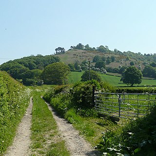
Yarnbury Castle is the site of a multiphase, multivallate Iron Age hillfort near the village of Steeple Langford, Wiltshire, England. The site covers an area of 28.5 acres (11.5 ha), and was extensively surveyed and investigated by the Royal Commission on the Historical Monuments of England in 1991, with finds of Iron Age and Romano-British pottery, Iron Age and Roman coins, and burials of human remains. There is much evidence of prolonged and extensive settlement of the site, including evidence of around 130 structures of various sizes, most probably representing a mix of round houses, pits, and other features. It was designated as a scheduled monument in 1925.

Stourton with Gasper is a civil parish in the southwest of the English county of Wiltshire. Its main settlement is the village of Stourton, along with the hamlets of Bonham and Gasper. The village is about 2+1⁄2 miles (4 km) northwest of the small town of Mere, and is part of the Stourhead estate, which includes much of the west of the parish. The estate is in the ownership of the National Trust, and the entrance to the estate's famous house and garden is through the village.

Upavon is a rural village and civil parish in the county of Wiltshire, England. As its name suggests, it is on the upper portion of the River Avon which runs from north to south through the village. It is on the north edge of Salisbury Plain about 4 miles (6.4 km) south of Pewsey, 10 miles (16 km) southeast of the market town of Devizes, and 20 miles (32 km) north of the cathedral city of Salisbury. The A345 and A342 roads run through the village.
Vespasian's Camp is an Iron Age hillfort just west of the town of Amesbury, Wiltshire, England. The hillfort is less than 3 kilometres (2 mi) from the Neolithic and Bronze Age site of Stonehenge, and was built on a hill next to the Stonehenge Avenue; it has the River Avon on its southern side and the A303 road on its northern edge. The site is a scheduled monument and lies within the boundaries of the Stonehenge World Heritage Site.
Croft Ambrey is an Iron Age hill fort in Herefordshire, England.

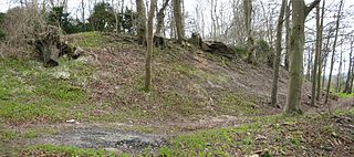
Scratchbury Camp is the site of an Iron Age univallate hillfort on Scratchbury Hill, overlooking the Wylye valley about 1 km northeast of the village of Norton Bavant in Wiltshire, England. The fort covers an area of 37 acres (15 ha) and occupies the summit of the hill on the edge of Salisbury Plain, with its four-sided shape largely following the natural contours of the hill.

Castle Ditches is the site of an Iron Age trivallate hillfort in the south-east of Tisbury parish in Wiltshire, England.

Chiselbury is the site of an Iron Age univallate hillfort in Wiltshire, England. The hillfort is sub-circular in plan, and encloses an area of approximately 10.5 acres (460,000 sq ft). It is defined by an earthen rampart up to 3.6 metres (12 ft) in height and an external ditch, up to a maximum of 1.6 metres (5.2 ft) in depth. A gap in the south-eastern side of the rampart, and a corresponding causeway across the ditch, is thought to be the original entrance and is associated with a small 'D' shaped embanked enclosure, which is apparently visible on aerial photographs. Although the enclosure has subsequently been degraded by ploughing, it is still apparent as a series of low earthworks.
Chisenbury Camp is the site of an Iron Age univallate hillfort in Broad Chalke parish in Wiltshire, England. The site comprises a small circular 5-acre enclosure that was levelled in 1931. The site was partially excavated in the 19th century and there were finds of ceramics, worked stone, worked animal bone and remains of human burial; some are held by the Wiltshire Museum at Devizes. It is a scheduled monument.

Knook Castle is the site of an Iron Age univallate hillfort on Knook Down, near the village of Knook in Wiltshire, England, but largely within the civil parish of Upton Lovell. It has also been interpreted as a defensive cattle enclosure associated with nearby Romano-British settlements. It is roughly rectangular in plan with a single entrance on the south/south-east side, but with a later break in the wall on the western side. The site is a scheduled monument.
Holkham Camp, or Holkham Fort, is an Iron Age fort in Norfolk, England, about 1 mile (1.6 km) north-west of the village of Holkham. It is a scheduled monument.

Chalbury Hillfort is an Iron Age hillfort about 1 mile (1.6 km) south-east of the village of Bincombe, in Dorset, England. It is a scheduled monument.

Hollingbury Castle, also known as Hollingbury Camp and Hollingbury Hillfort, is an Iron Age hillfort on the northern edge of Brighton, in East Sussex, England. It is adjacent to Hollingbury Park Golf Course.

Buzbury Rings is an Iron Age hillfort about 2 miles (3.2 km) east of Blandford Forum and 1 mile (1.6 km) northwest of the village of Tarrant Keyneston, in Dorset, England.

The Martin Down Enclosure is an archaeological site on Martin Down, near the village of Martin, in Hampshire, England. It is near the boundaries with Dorset and Wiltshire.

Thundersbarrow Hill is an archaeological site in West Sussex, England. It is on a chalk ridge, aligned north-west to south-east, on the South Downs north of Shoreham-by-Sea.

Woodcutts Settlement is an archaeological site of the late Iron Age and Romano-British period on Cranborne Chase, England. It is situated about 1 mile (1.6 km) north of the hamlet of Woodcutts, and about 1.75 miles (2.8 km) north-west of the village of Sixpenny Handley, in Dorset, near the boundary with Wiltshire. It is a scheduled monument.
Brandon Camp is an archaeological site, about 1 mile south of Leintwardine, in Herefordshire. England. It is a hillfort of the Iron Age, which later became a Roman fort. The site is a scheduled monument.


