Buckland Rings

Last updated

Buckland Rings
Southern ramparts of Buckland Rings iron-age camp viewed from the south - geograph.org.uk - 24952.jpg
Southern ramparts of Buckland Rings
Hampshire UK location map.svg
Archaeological site icon (red).svg
Shown within Hampshire
Location Lymington, Hampshire
grid reference SZ314968
Coordinates 50°46′13″N1°33′19″W / 50.77022°N 1.55525°W / 50.77022; -1.55525 Coordinates: 50°46′13″N1°33′19″W / 50.77022°N 1.55525°W / 50.77022; -1.55525
Type Hillfort
Area2.8 hectares
Height2.4 metres
History
Periods Iron Age
Site notes
Excavation dates1935
Archaeologists Christopher Hawkes
ConditionDamaged on the east and west sides
Ownership Hampshire County Council
Public accessYes

Buckland Rings is the site of an Iron Age hill fort in the town of Lymington, Hampshire. Today, the mounds and dykes around the outside which once constituted its defences are still clearly visible, although the outer bank lies under the road on the west side, and on the south-east it is nearly ploughed-out. Excavations of the inner and middle ramparts in 1935 revealed that they were of wall-and-fill construction, retained at the front by upright timber beams and walls of cut and laid turf. The entrance, which lies on the east side, was also excavated revealing a long entrance passage and the postholes for a pair of stout gateposts. The site was bought by Hampshire County Council in 1989 to ensure its preservation, and it is open to the public from the A337 road onto which part of it faces.

Contents

Overview

3D view of the digital terrain model Buckland Rings Digital Terrain Model.jpg
3D view of the digital terrain model

Buckland Rings is a triple-banked, rectangular encampment dating from the Iron Age. Although this type of enclosure is commonly referred to as a hillfort, Buckland Rings is in fact only 27 metres above sea-level. [1] This type of site is rare in lowland areas and as such it is the best preserved and most important in the Hampshire/Dorset basin. [2] It stands on a spur of gravel and encloses 2.8 hectares. [1] The innermost bank stands 2.4 metres high whilst the middle one is lower but unusually wide. [1] Buckland Rings has well-preserved triple banks and double ditches, [2] although the outer bank lies under the road on the west side, [1] and the east side which contained the entrance was partly ploughed up in the mid 18th century. [2]

Early reports

Buckland Rings depicted by Thomas Wright in 1744 Buckland Rings by Thomas Wright 1744.png
Buckland Rings depicted by Thomas Wright in 1744

The earliest report of Buckland Rings was by Thomas Wright who visited the site in the summer of 1743. [3] He described Buckland Rings as "very strong, with double ditches, and triple Vallums, upon the Top of an Hill, three Ways guarded by a natural Ascent." Wright drew a plan of the fort, which is especially valuable as some of the eastern ramparts were flattened by a farmer around 1750. [4] Wright also noticed the presence of a lower camp nearby (Ampress Camp) together with a farm called Ampress Farm, which he understood to be "Ambrose Farm", and he thought that it was "not improbable" that the site was "a principal station" belonging to the 5th-century Romano-British war-leader Ambrosius Aurelianus. [3]

This thought was elaborated on by Richard Warner in 1793 who fancifully described how Ambrosius "unable to support the furious attacks of the invaders, was probably driven, ... till he reached the neighbourhood of Lymington." [5] Warner describes how "an earthwork, a rude sample of British castrametation, may still be discerned at this place." [5]

Others simply thought that Buckland Rings was a Roman camp, [6] but in 1885 the newly formed Hampshire Field Club and Archaeological Society examined the site and resolved that the word "Roman" should be omitted from future Ordnance Survey maps. [7]

1935 Excavations

To date the only excavation of the site was that conducted over a three-week period in 1935 under the supervision of Christopher Hawkes, following some preparatory work in 1934. [8] Hawkes limited his excavations to areas around the entrance, and especially to the inner and middle ramparts and ditches on the east side where the ramparts had been almost totally removed around 1750. [9]

Inner ditch and rampart

The inner ditch was of V-section, 3.5 metres deep and 8.8 metres wide. Postholes for upright beams were found at the front of the inner rampart. [9] These posts would have held horizontal timbers forming a wooden revetment to the front of the rampart. [8] The rampart was composed of sand and gravel dug from the ditches, [8] together with a wall of cut and laid turf into which the posts had been recessed. [9] Additional postholes were discovered 5.8 metres behind the front postholes. These presumably held anchor timbers for the front wall, [9] although the 5.8 metre distance between the rows is thought somewhat excessive for simple cross-bracing. [10]

Inner ditch in the northern ramparts of Buckland Rings Ditch in the northern ramparts of Buckland Rings - geograph.org.uk - 255990.jpg
Inner ditch in the northern ramparts of Buckland Rings

Middle rampart

The middle rampart was apparently rather lower than the inner rampart, since the middle ditch was rather smaller than the inner ditch. [9] Only one posthole was found, but it is thought that this rampart also had a wall-and-fill structure with upright beams and a facing wall of cut and laid turf. [9]

Entrance

The entrance was a narrow passage extending some 60 metres in length from the outer edge of the second ditch to gates at the inmost end. [9] The width of the passage varied between 8 and 12 metres along most of its length before narrowing to some 3 to 3.5 metres at the gates. [9] The gates were supported on timbers in two massive holes, 90 centimetres in diameter. [11]

Evaluation

The finds from the excavation were very few, and of limited help in dating the site. A small iron chain was found, consisting of a circular ring and remains of five oval links. [11] There were also a few scraps of Iron-Age pottery, and a fragment of a bronze tube believed to be a "horn-cap," a type of object which it is believed was mounted on the ends of chariot yokes. [12] Hawkes himself believed that the fort was built in the first century BC and was demolished in about 43 AD, possibly by the Romans. [8] Advances in Iron-Age archaeology since the 1930s have now led modern archaeologists to adopt a longer chronology for the site. [8] The site may date from the Early to Middle Iron-Age (c. 5th century BC) [12] and may have started out with a single bank and ditch system. [2] Later the ramparts may have been refurbished, [9] and the outer ramparts were added to the original construction. [13] Many hillforts in southern England had been abandoned well before the Roman conquest, and Buckland Rings may have fallen out use by the 1st century BC. [12] The finds from excavation are stored in Winchester. [1]

1993 survey

A geophysical survey was conducted in the interior of Buckland Rings in 1993 using magnetometry. [14] However, geological conditions at the site for magnetic detection of archaeology were discovered to be poor and features such as posthole structures were undetectable. [14] The survey was able to trace the course of the missing defences, locate the position of Hawkes's excavations, and partially define the entrance features. Evidence of settlement activity, however, was inconclusive. [14]

The site today

Today the site is well preserved, and the only obvious damage is where parts of the eastern ramparts were flattened in the 18th century, and where the outer rampart on the western side has been encroached upon by the road. [2] In addition, two houses were built inside the west end of the fort in the early twentieth century. [2] In 1986, a property developer announced plans to build a leisure centre inside Buckland Rings. [15] These plans were rejected in a public inquiry in 1988. [15] Since 1989 Buckland Rings has been in the care and ownership of Hampshire County Council and it is now open to visitors on foot. [2] Buckland Rings is now a Scheduled Ancient Monument. [2] There is also a bicycle Dirt jumping track adjacent to Buckland rings situated in a disused gravel pit. [16]

Ampress Camp as depicted by Thomas Wright in 1744. North is to the right Ampress Camp by Thomas Wright 1744.png
Ampress Camp as depicted by Thomas Wright in 1744. North is to the right

Ampress Camp

Close to Buckland Rings is another earthwork enclosure known as Ampress Camp (or Ampress Hole) (grid reference SZ320970 ). It lies 360 metres east of Buckland Rings alongside Lymington River, [17] and about 200 metres north of Lymington New Forest Hospital. Ampress Camp was noted by Thomas Wright in 1744, who described it as "upon a lower Ground, close by a River (which defends it on one Side), with a Ditch and Vallum half round, and a kind of Morass on the other." [3] The outer rampart depicted by Wright has long since been flattened, and the ditches have been filled in. [18] Waterworks occupy the northern part of the site, and commercial buildings have encroached upon the western half. [18] Part of the interior (the southeastern part) is still viewable as a field, [18] and a sunken lane runs a short distance along the line of the southern inner ditch. [19] There have been only limited excavations, but a few scraps of pottery found at the site may date from the Iron Age. [15] If the camp does date from the Iron Age, then it is unusual to have two Iron Age camps so close together. [15] Ampress Camp may perhaps have formed a beachhead for the inhabitants of Buckland Rings, [17] or it may have been occupied during a different period of the Iron Age. [15]

Citations

  1. 1 2 3 4 5 Dyer 2001 , p. 237
  2. 1 2 3 4 5 6 7 8 New Forest District Council 2008
  3. 1 2 3 Wright 1744
  4. Close-Brooks 2000 , p. 1
  5. 1 2 Warner 1793 , p. 78
  6. e.g. Lewis 1831
  7. Hampshire Field Club and Archaeological Society 1887 , p. 11
  8. 1 2 3 4 5 Close-Brooks 2000 , p. 2
  9. 1 2 3 4 5 6 7 8 9 Avery 1993 , p. 53
  10. Cunliffe 2005 , p. 353
  11. 1 2 Avery 1993 , p. 54
  12. 1 2 3 Close-Brooks 2000 , p. 3
  13. Cunliffe 2005 , p. 357
  14. 1 2 3 Payne 1993
  15. 1 2 3 4 5 Close-Brooks 2000 , p. 7
  16. "Buckland Rings Trail - Mountain Biking" . Retrieved 7 March 2011.
  17. 1 2 Dyer 1981 , p. 154
  18. 1 2 3 Close-Brooks 2000 , p. 4
  19. Close-Brooks 2000 , p. 5

Related Research Articles

Hillfort Type of earthworks used as a fortified refuge or defended settlement

A hillfort is a type of earthwork used as a fortified refuge or defended settlement, located to exploit a rise in elevation for defensive advantage. They are typically European and of the Bronze Age or Iron Age. Some were used in the post-Roman period. The fortification usually follows the contours of a hill and consists of one or more lines of earthworks, with stockades or defensive walls, and external ditches. Hillforts developed in the Late Bronze and Early Iron Age, roughly the start of the first millennium BC, and were used in many Celtic areas of central and western Europe until the Roman conquest.

Uffington Castle

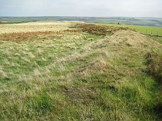
Uffington Castle is an early Iron Age univallate hillfort in Oxfordshire, England. It covers about 32,000 square metres and is surrounded by two earth banks separated by a ditch with an entrance in the western end. A second entrance in the eastern end was apparently blocked up a few centuries after it was built. The original defensive ditch was V-shaped with a small box rampart in front and a larger one behind it. Timber posts stood on the ramparts. Later the ditch was deepened and the extra material dumped on top of the ramparts to increase their size. A parapet wall of sarsen stones lined the top of the innermost rampart. It is very close to the Uffington White Horse on White Horse Hill.

Danebury Iron Age hillfort in Hampshire, England

Danebury is an Iron Age hill fort in Hampshire, England, about 19 kilometres (12 mi) north-west of Winchester. The site, covering 5 hectares, was excavated by Barry Cunliffe in the 1970s. Danebury is considered a type-site for hill forts, and was important in developing the understanding of hill forts, as very few others have been so intensively excavated.

Castle Dore is an Iron Age hill fort (ringfort) near Fowey in Cornwall, United Kingdom located at grid reference SX103548. It was probably occupied from the 5th or 4th centuries BC until the 1st century BC. It consists of two ditches surrounding a circular area 79 metres (259 ft) in diameter. Excavated in the 1930s, it is one of the most intensively investigated Iron Age hillforts in Cornwall.

Rainsborough Camp

Rainsborough Camp is an Iron Age hillfort in West Northamptonshire, England, between the villages of Croughton, Aynho, and Charlton.

The Trundle Archaeological site in West Sussex, England

The Trundle is an Iron Age hillfort on St Roche's Hill about 4 miles (6 km) north of Chichester, West Sussex, England, built on the site of a causewayed enclosure, a form of early Neolithic earthwork found in northwestern Europe. Causewayed enclosures were built in England from shortly before 3700 BC until at least 3500 BC; they are characterized by the full or partial enclosure of an area with ditches that are interrupted by gaps, or causeways. Their purpose is not known; they may have been settlements, meeting places, or ritual sites. Hillforts were built as early as 1000 BC, in the Late Bronze Age, and continued to be built through the Iron Age until shortly before the Roman occupation. A chapel dedicated to St Roche was built on the hill around the end of the 14th century; it was in ruins by 1570. A windmill and a beacon were subsequently built on the hill. The site was occasionally used as a meeting place in the post-medieval period.

Moel y Gaer, Llanbedr Iron Age hillfort in Denbighshire, Wales

Moel y Gaer, also known as Moel-y-Gaer Camp or Moel y Gaer Hillfort, is an Iron Age hillfort located on a western spur of the Clwydian Range, near the village of Llanbedr, Denbighshire, Wales. The site is a scheduled monument, classified as a prehistoric defensive hillfort.

Blewburton Hill Hillfort in Oxfordshire, England

Blewburton Hill is the site of an Iron Age hillfort located in Oxfordshire, in the southeast of England. It was a univallate hillfort. The area is mostly farmland with some small areas of wooded copse to the south and the northeast. The hill fort may have been occupied from the 4th century BC to the 1st century BC, and replaced a small settlement surrounded by a stockade, which is estimated to have been built in the 5th or 6th century BC.

Scratchbury Camp Iron Age hillfort in Wiltshire, England

Scratchbury Camp is the site of an Iron Age univallate hillfort on Scratchbury Hill, overlooking the Wylye valley about 1 km northeast of the village of Norton Bavant in Wiltshire, England. The fort covers an area of 37 acres (15 ha) and occupies the summit of the hill on the edge of Salisbury Plain, with its four-sided shape largely following the natural contours of the hill.

Bury Camp Iron Age hillfort in Wiltshire, England

Bury Camp is the site of an Iron Age multivallate hillfort in north-west Wiltshire, England. It occupies a triangular promontory of Colerne Down, in the north of Colerne parish, at the southern edge of the Cotswold Hills between two spurs of a river valley. The enclosed area of approximately 9.2ha is surrounded by a ditch 4m wide and up to 1m deep, and an outer rampart up to 1.5m high on the east and northwestern sides and up to 2m high on the southwestern side, across the neck of the promontory.

Cholesbury Camp Iron Age hillfort in Buckinghamshire, England

Cholesbury Camp is a large and well-preserved Iron Age hill fort on the northern edge of the village of Cholesbury in Buckinghamshire, England. It is roughly oval-shaped and covers an area, including ramparts, of 15 acres (6.1 ha), and measures approximately 310 m (1,020 ft) north-east to south-west by 230 m (750 ft) north-west to south-east. The interior is a fairly level plateau which has been in agricultural use since the medieval period. The hill fort is now a scheduled ancient monument.

Bratton Castle Iron Age hillfort in Wiltshire, England

Bratton Castle is a bivallate Iron Age built hill fort on Bratton Down, at the western edge of the Salisbury Plain escarpment. The hill fort comprises two circuits of ditch and bank which together enclose a pentagonal area of 9.3 hectares.

Bigbury Camp

Bigbury Camp is a univallate hill fort in the parish of Harbledown and Rough Common in Kent in England. The fort is a Scheduled Ancient Monument, with a list entry identification number of 1005169. Bigbury Camp is the only confirmed Iron Age hill fort in east Kent. It is managed by Kent Wildlife Trust.

Dudsbury Camp

Dudsbury Camp is one of a series of Iron Age earthworks in Dorset, starting from Hambledon Hill, and including Hod Hill, Spetisbury Rings, Buzbury Rings, Badbury Rings and Dudsbury Camp. The Iron Age port at Hengistbury Head forms a final Iron Age monument in this small chain of sites. The fort is located near the village of West Parley.

Caesars Camp, Rushmoor and Waverley Iron Age hillfort in Hampshire, England

Caesar's Camp is an Iron Age hill fort straddling the border of the counties of Surrey and Hampshire in southern England. The fort straddles the borough of Waverley in Surrey and the borough of Rushmoor and the district of Hart, both in Hampshire. Caesar's Camp is a Scheduled Ancient Monument with a list entry identification number of 1007895. It lies approximately 3 kilometres (1.9 mi) north of the town of Farnham, and a similar distance west of Aldershot. The hillfort lies entirely within the Bourley and Long Valley Site of Special Scientific Interest. Caesar's Camp is a multivallate hillfort, a fort with multiple defensive rings, occupying an irregular promontory, with an entrance on the south side. The site has been much disturbed by military activity, especially at the southeast corner. The remains of the hillfort are considered to be of national importance.

Llwynda-Ddu Camp, also known as Llwynda-Ddu Hillfort, is a small Iron Age earthwork in Pentyrch, Cardiff in South Wales. The site is a scheduled monument, described as a prehistoric, defensive hillfort.

Hollingbury Castle

Hollingbury Castle, also known as Hollingbury Camp and Hollingbury Hillfort, is an Iron Age hillfort on the northern edge of Brighton, in East Sussex, England. It is adjacent to Hollingbury Park Golf Course.

Dungeon Hill is an Iron Age hillfort, about 1+14 miles north of the village of Buckland Newton in Dorset, England. It is a scheduled monument.

South Weald Camp

South Weald Camp was a hillfort based in South Weald, Brentwood, Essex, England. Roughly circular in plan, the fort covered 2.8 hectares, with a suggested construction date in the late Iron Age, from the 1st century BC to the 1st century AD. The location is associated in this period with the Catuvellauni and the Trinovantes.

Brandon Camp is an archaeological site, about 1 mile south of Leintwardine, in Herefordshire. England. It is a hillfort of the Iron Age, which later became a Roman fort. The site is a scheduled monument.

References

Further reading