Hampshire Basin

Last updated

Geological map of southeastern England and parts of France, showing the Hampshire Basin in its regional context. Geologic map SE England & Channel EN.svg
Geological map of southeastern England and parts of France, showing the Hampshire Basin in its regional context.
North-south cross-section of the upper crust of southern England, showing the Paleogene London Basin to the north and Hampshire Basin to the south. Also visible is the inverted nature of the Weald, which was a basin during the Early Cretaceous and thus has a relatively thick Lower Cretaceous sequence. Vertical exaggeration 1:5. WealdBasinCrossSection.png
North-south cross-section of the upper crust of southern England, showing the Paleogene London Basin to the north and Hampshire Basin to the south. Also visible is the inverted nature of the Weald, which was a basin during the Early Cretaceous and thus has a relatively thick Lower Cretaceous sequence. Vertical exaggeration 1:5.
Geological map of the Hampshire Basin Geological map of Hampshire Basin.jpg
Geological map of the Hampshire Basin

The Hampshire Basin is a geological basin of Palaeogene age in southern England, underlying parts of Hampshire, the Isle of Wight, Dorset, and Sussex. Like the London Basin to the northeast, it is filled with sands and clays of Paleocene and younger ages and it is surrounded by a broken rim of chalk hills of Cretaceous age.

Contents

Extent

The Hampshire Basin is the traditional name for the landward section of a basin underlying the northern English Channel and much of central southern England, known more fully as the Hampshire-Dieppe Basin. It stretches a little over 100 miles (160 km) from the Dorchester area in the west to Beachy Head in the east. Its southern boundary is marked by a monocline, the Purbeck Monocline, resulting in a near-vertical chalk ridge which forms the Purbeck Hills of Dorset, running under the sea from Old Harry Rocks to The Needles and the central spine of the Isle of Wight and continuing under the English Channel as the Wight-Bray monocline. The northern limit is the chalk of the South Downs, Salisbury Plain and Cranborne Chase. The basin at its widest is around 30 miles (48 km), north-west to south-east, between Salisbury and Newport, Isle of Wight. The area west of the River Avon is usually known as the Poole Basin.[ citation needed ]

Geography

The basin includes areas of forest and heath including Wareham Forest, Arne and the New Forest and the large south coast settlements of Bournemouth, Southampton and Portsmouth. The coast has many drowned valleys (rias) including The Solent, Poole Harbour, Southampton Water, Portsmouth Harbour, Chichester Harbour, Langstone Harbour, Pagham Harbour, Yarmouth, Cowes and Bembridge. In addition to the northern half of the Isle of Wight which lies within the basin, the harbours contain inhabited islands including Brownsea Island, Portsea Island, Hayling Island and Thorney Island.

Drainage

The Hampshire Basin has no single dominant river. In former times the Frome and Solent rivers would have drained much of the basin from west to east, fed by tributaries flowing from the north and south. [1] [2] At the end of the last ice age this system was disrupted by rising sea levels, which separated the Isle of Wight from the mainland. Today the western part of the basin drains via the rivers Frome and Piddle into Poole Harbour, and via the Stour and Avon directly to the English Channel. The central part drains into the Solent (directly or via Southampton Water), through the Lymington River, Test, Itchen, Meon, Hamble, Western Yar, Medina and Eastern Yar. The eastern part of the basin is a narrow coastal plain draining into the many harbours via small streams, and is crossed by larger rivers draining the Weald including the Arun and Adur.

Geology

The main basin consists of an asymmetric syncline in the Cretaceous chalk, with a gentle dip southwards from Salisbury Plain terminating abruptly at a near vertical monocline in the south. The chalk surface dips from around 170 metres (560 ft) above sea level west of Winchester to 600 metres (2,000 ft) below sea level at Newport, [3] before rising abruptly to around 200 metres (660 ft) above sea level in parts of the central hills of the Isle of Wight and the Purbeck Hills. The chalk can be visualised as a thin layer draped over rigid blocks of older rocks at depth, which have moved vertically due to the Alpine Orogeny.

Beneath the chalk the geology is complex. It is believed that a series of major blocks separated by faults trending NW-SE is fragmented into smaller blocks by numerous east-west trending faults; one such block acts as a trap for the Wytch Farm oil field. These blocks have moved vertically relative to each other during late Palaeozoic and Mesozoic times, resulting in considerable variations in the thickness of the various formations deposited over them before the chalk. Rocks of Lower Greensand (Aptian) age were deposited over an eroded surface, which ranges from Great Oolite (Early Jurassic Bathonian) to Weald Clay (mid-Cretaceous Hauterivian) in age. [4] The chalk itself varies considerably in thickness, with the results of a marine transgression progressing across into Dorset from the east. There is evidence that the top of the Upper Greensand to the west is the same age as the oldest chalk in the Isle of Wight. [3]

Above the chalk the basin contains Palaeogene sediments ranging from Thanetian (Palaeocene) age to Rupelian (Oligocene) age. The oldest beds, the Lambeth Group ('Reading Beds') and Thames Group ('London Clay') outcrop in narrow bands towards the perimeter of the basin, from the coast at Studland, around the perimeter of the Dorset heathlands, [5] north and east past Romsey, swinging southeast past Eastleigh and eastwards towards Chichester, Worthing and Shoreham-by-Sea. Within this rim, over the greater part of the basin is an outcrop of younger Eocene deposits, the Bagshot, Bracklesham and Barton beds. The youngest, Oligocene beds (Bouldnor Formation) only occur on the northern Isle of Wight; the Headon Hill beds of the New Forest, formerly classified as Oligocene, are now regarded as late Eocene. [4]

The simple basin structure is complicated by localised folding. A smaller outcrop of Palaeocene and Eocene deposits occurs in a small syncline to the south-east of Salisbury. [6] An anticline to the north of Portsmouth results in the significant chalk ridge of Portsdown Hill within the younger sediments; the London Clay to the north contains the Forest of Bere. [7] A similar structure further east causes chalk to outcrop between Bognor Regis and Worthing, separated from the chalk of the South Downs by a belt of Reading Beds and London Clay continuing from Havant through Chichester and south of Arundel to the coast at Lancing.

It is likely that the London and Hampshire basins were initially part of a single larger area of deposition covering the whole of southeast England during the Palaeocene. The two basins were progressively separated by the emergence of the Weald-Artois Anticline during the Eocene. By the Oligocene the London Basin was wholly dry land, and only a small part of the Hampshire Basin, centred on the modern Solent, was an area of marine deposition. [8]

See also

Related Research Articles

<span class="mw-page-title-main">The Solent</span> Strait separating the Isle of Wight from the mainland of England

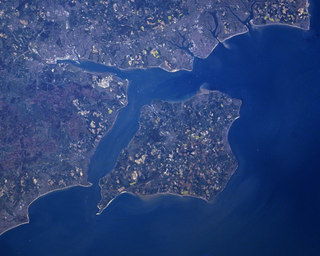
The Solent is a strait between the Isle of Wight and mainland Great Britain. It is about 20 miles long and varies in width between 2+12 and 5 mi, although the Hurst Spit which projects 1+12 mi (2.4 km) into the Solent narrows the sea crossing between Hurst Castle and Colwell Bay to just over 1 mi (1.6 km).

<span class="mw-page-title-main">River Frome, Dorset</span> River in Dorset, England

The River Frome is a river in Dorset in the south of England. At 30 miles (48 km) long it is the major chalkstream in southwest England. It is navigable upstream from Poole Harbour as far as the town of Wareham.

<span class="mw-page-title-main">Poole Harbour</span> Natural harbour in England

Poole Harbour is a large natural harbour in Dorset, southern England, with the town of Poole on its shores. The harbour is a drowned valley (ria) formed at the end of the last ice age and is the estuary of several rivers, the largest being the Frome. The harbour has a long history of human settlement stretching to pre-Roman times. The harbour is extremely shallow, with one main dredged channel through the harbour, from the mouth to Holes Bay.

<span class="mw-page-title-main">Isle of Purbeck</span> Peninsula in Dorset, England

The Isle of Purbeck is a peninsula in Dorset, England. It is bordered by water on three sides: the English Channel to the south and east, where steep cliffs fall to the sea; and by the marshy lands of the River Frome and Poole Harbour to the north. Its western boundary is less well defined, with some medieval sources placing it at Flower's Barrow above Worbarrow Bay. John Hutchins, author of The History and Antiquities of the County of Dorset, defined Purbeck's western boundary as the Luckford Lake steam, which runs south from the Frome. According to writer and broadcaster Ralph Wightman, Purbeck "is only an island if you accept the barren heaths between Arish Mell and Wareham as cutting off this corner of Dorset as effectively as the sea." The most southerly point is St Alban's Head.

<span class="mw-page-title-main">Chalk Group</span>

The Chalk Group is the lithostratigraphic unit which contains the Upper Cretaceous limestone succession in southern and eastern England. The same or similar rock sequences occur across the wider northwest European chalk 'province'. It is characterised by thick deposits of chalk, a soft porous white limestone, deposited in a marine environment.

<span class="mw-page-title-main">Greensand</span> Sand or sandstone which has a greenish color

Greensand or green sand is a sand or sandstone which has a greenish color. This term is specifically applied to shallow marine sediment that contains noticeable quantities of rounded greenish grains. These grains are called glauconies and consist of a mixture of mixed-layer clay minerals, such as smectite and glauconite. Greensand is also loosely applied to any glauconitic sediment.

<span class="mw-page-title-main">Wytch Farm</span> Oil field and processing site in Dorset, England

Wytch Farm is an oil field and processing facility in the Purbeck district of Dorset, England. It is the largest onshore oil field in western Europe. The facility, taken over by Perenco in 2011, was previously operated by BP. It is located in a coniferous forest on Wytch Heath on the southern shore of Poole Harbour, two miles (3.2 km) north of Corfe Castle. Oil and natural gas (methane) are both exported by pipeline; liquefied petroleum gas is exported by road tanker.

<span class="mw-page-title-main">Geology of Dorset</span>

Dorset is a county in South West England on the English Channel coast. Covering an area of 2,653 square kilometres (1,024 sq mi); it borders Devon to the west, Somerset to the north-west, Wiltshire to the north-east, and Hampshire to the east. The great variation in its landscape owes much to the underlying geology, which includes an almost unbroken sequence of rocks from 200 to 40 million years ago (Mya) and superficial deposits from 2 Mya to the present. In general, the oldest rocks appear in the far west of the county, with the most recent (Eocene) in the far east. Jurassic rocks also underlie the Blackmore Vale and comprise much of the coastal cliff in the west and south of the county; although younger Cretaceous rocks crown some of the highpoints in the west, they are mainly to be found in the centre and east of the county.

<span class="mw-page-title-main">Purbeck Hills</span> Chalk ridge in England

The Purbeck Hills, also called the Purbeck Ridge or simply the Purbecks, are a ridge of chalk downs in Dorset, England. It is formed by the structure known as the Purbeck Monocline. The ridge extends from Lulworth Cove in the west to Old Harry Rocks in the east, where it meets the sea. The hills are part of a system of chalk downlands in southern England formed from the Chalk Group which also includes Salisbury Plain and the South Downs. For most of their length the chalk of the Purbeck Hills is protected from coastal erosion by a band of resistant Portland limestone. Where this band ends, at Durlston Head, the clay and chalk behind has been eroded, creating Poole Bay and the Solent. The ridge of steeply dipping chalk that forms the Purbeck Hills continues further east on the Isle of Wight.

The geology of Hampshire in southern England broadly comprises a gently folded succession of sedimentary rocks dating from the Cretaceous and Palaeogene periods. The lower (early) Cretaceous rocks are sandstones and mudstones whilst those of the upper (late) Cretaceous are the various formations which comprise the Chalk Group and give rise to the county's downlands. Overlying these rocks are the less consolidated Palaeogene clays, sands, gravels and silts of the Lambeth, Thames and Bracklesham Groups which characterise the Hampshire Basin.

Purbeck Marble is a fossiliferous limestone found in the Isle of Purbeck, a peninsula in south-east Dorset, England. It is a variety of Purbeck stone that has been quarried since at least Roman times as a decorative building stone.

<span class="mw-page-title-main">Wealden Group</span>

The Wealden Group, occasionally also referred to as the Wealden Supergroup, is a group in the lithostratigraphy of southern England. The Wealden group consists of paralic to continental (freshwater) facies sedimentary rocks of Berriasian to Aptian age and thus forms part of the English Lower Cretaceous. It is composed of alternating sands and clays. The sandy units were deposited in a flood plain of braided rivers, the clays mostly in a lagoonal coastal plain.

<span class="mw-page-title-main">London Basin</span> The basin of river Thames in London

The London Basin is an elongated, roughly triangular sedimentary basin approximately 250 kilometres (160 mi) long which underlies London and a large area of south east England, south eastern East Anglia and the adjacent North Sea. The basin formed as a result of compressional tectonics related to the Alpine orogeny during the Palaeogene period and was mainly active between 40 and 60 million years ago.

<span class="mw-page-title-main">Geology of East Sussex</span> Overview of the geology of East Sussex

The geology of East Sussex is defined by the Weald–Artois anticline, a 60 kilometres (37 mi) wide and 100 kilometres (62 mi) long fold within which caused the arching up of the chalk into a broad dome within the middle Miocene, which has subsequently been eroded to reveal a lower Cretaceous to Upper Jurassic stratigraphy. East Sussex is best known geologically for the identification of the first dinosaur by Gideon Mantell, near Cuckfield, to the famous hoax of the Piltdown man near Uckfield.

<span class="mw-page-title-main">Purbeck Monocline</span>

The Purbeck Monocline is a geological fold in southern England. The term 'fold' is used in geology when one or more originally flat sedimentary strata surfaces are bent or curved as a result of plastic deformation. A monocline is a step-like fold, in which one limb is roughly horizontal. The Purbeck Monocline was formed during the late Oligocene and early Miocene epochs, about 30 million years ago. It is the northernmost 'ripple' of the Alpine Orogeny.

The Bouldnor Formation is a geological formation in the Hampshire Basin of southern England. It is the youngest formation of the Solent Group and was deposited during the uppermost Eocene and lower Oligocene.

<span class="mw-page-title-main">Geography of Dorset</span>

Dorset is a county located in the middle of the south coast of England. It lies between the latitudes 50.512°N and 51.081°N and the longitudes 1.682°W and 2.958°W, and occupies an area of 2,653 km2. It spans 90 kilometres (56 mi) from east to west and 63 kilometres (39 mi) from north to south.

<span class="mw-page-title-main">Geology of the Isle of Wight</span>

The geology of the Isle of Wight is dominated by sedimentary rocks of Cretaceous and Paleogene age. This sequence was affected by the late stages of the Alpine Orogeny, forming the Isle of Wight monocline, the cause of the steeply-dipping outcrops of the Chalk Group and overlying Paleogene strata seen at The Needles, Alum Bay and Whitecliff Bay.

The geology of West Sussex in southeast England comprises a succession of sedimentary rocks of Cretaceous age overlain in the south by sediments of Palaeogene age. The sequence of strata from both periods consists of a variety of sandstones, mudstones, siltstones and limestones. These sediments were deposited within the Hampshire and Weald basins. Erosion subsequent to large scale but gentle folding associated with the Alpine Orogeny has resulted in the present outcrop pattern across the county, dominated by the north facing chalk scarp of the South Downs. The bedrock is overlain by a suite of Quaternary deposits of varied origin. Parts of both the bedrock and these superficial deposits have been worked for a variety of minerals for use in construction, industry and agriculture.

<span class="mw-page-title-main">Wessex Basin</span> Petroliferous geological area on the southern coast of England and the English Channel

The Wessex Basin is a petroleum-bearing geological area located along the southern coast of England and extending into the English Channel. The onshore part of the basin covers approximately 20,000 km2 and the area that encompasses the English Channel is of similar size. The basin is a rift basin that was created during the Permian to early Cretaceous in response to movement of the African plate relative to the Eurasian plate. In the late Cretaceous, and again in the Cenozoic, the basin was inverted as a distant effect of the Alpine orogeny. The basin is usually divided into 3 main sub-basins including the Winterborne-Kingston Trough, Channel Basin, and Vale of Pewsey Basin. The area is also rich in hydrocarbons with several offshore wells in the area. With the large interest in the hydrocarbon exploration of the area, data became more readily available, which improved the understanding of the type of inversion tectonics that characterize this basin.

References

  1. Jones K.C.D. (Ed), The Shaping of Southern England, Institute of British Geographers Special Publication 11, Academic Press, 1980, ISBN   0-12-388950-2
  2. Bird, E (1997), The Shaping of the Isle of Wight, Bradford on Avon:Ex Libris Press, ISBN   0-948578-83-1
  3. 1 2 Melville, R.V. & Freshney E.C (4th Ed 1982), The Hampshire Basin and adjoining areas, British Regional Geology series, Institute of Geological Sciences, London: HMSO, ISBN   0-11-884203-X
  4. 1 2 Andrews I.J & Balson P.S. (1995), Wight: Sheet 50N 02W Solid Geology, 1:250,000 Geological map series, Keyworth: British Geological Survey, ISBN   0-7518-3089-5.
  5. Edwards R.A., Crosby A. & Briden J.C (1983), Portland: Sheet 50N 04W Solid Geology, 1:250,000 Geological map series, Keyworth: British Geological Survey, ISBN   0-7518-1256-0
  6. Jackson, A.A. (1991), Chilterns: Sheet 51N 02W Solid Geology, 1:250,000 Geological map series, Keyworth: British Geological Survey, ISBN   978-0-7518-1899-4
  7. Trueman A.E. revised by Whittow J.B. and Hardy J.R (1971), Geology and Scenery in England and Wales, Harmondsworth: Penguin books, ISBN   0-14-020185-8
  8. Gibbard P.; Lewin J. (29 October 2007). "History of the major rivers of southern Britain during the Tertiary". Quaternary Palaeoenvironments Group. Retrieved 4 March 2008.