
Downland, chalkland, chalk downs or just downs are areas of open chalk hills, such as the North Downs. This term is used to describe the characteristic landscape in southern England where chalk is exposed at the surface. The name "downs" is derived from the Old English word dun, meaning "hill".
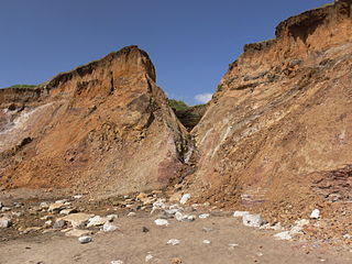
A chine is a steep-sided coastal gorge where a river flows to the sea through, typically, soft eroding cliffs of sandstone or clays. The word is still in use in central Southern England—notably in East Devon, Dorset, Hampshire and the Isle of Wight—to describe such topographical features. The term 'bunny' is sometimes used to describe a chine in Hampshire. The term chine is also used in some Vancouver suburbs in Canada to describe similar features.
The London Clay Formation is a marine geological formation of Ypresian age which crops out in the southeast of England. The London Clay is well known for its fossil content. The fossils from the lower Eocene rocks indicate a moderately warm climate, the tropical or subtropical flora. Though sea levels changed during the deposition of the clay, the habitat was generally a lush forest – perhaps like in Indonesia or East Africa today – bordering a warm, shallow ocean.

The Gault Formation is a geological formation of stiff blue clay deposited in a calm, fairly deep-water marine environment during the Lower Cretaceous Period. It is well exposed in the coastal cliffs at Copt Point in Folkestone, Kent, England, where it overlays the Lower Greensand formation, and underlies the Upper Greensand Formation. These represent different facies, with the sandier parts probably being deposited close to the shore and the clay in quieter water further from the source of sediment; both are believed to be shallow-water deposits.

Dorset is a county in South West England on the English Channel coast. Covering an area of 2,653 square kilometres (1,024 sq mi); it borders Devon to the west, Somerset to the north-west, Wiltshire to the north-east, and Hampshire to the east. The great variation in its landscape owes much to the underlying geology, which includes an almost unbroken sequence of rocks from 200 to 40 million years ago (Mya) and superficial deposits from 2 Mya to the present. In general, the oldest rocks appear in the far west of the county, with the most recent (Eocene) in the far east. Jurassic rocks also underlie the Blackmore Vale and comprise much of the coastal cliff in the west and south of the county; although younger Cretaceous rocks crown some of the highpoints in the west, they are mainly to be found in the centre and east of the county.

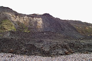
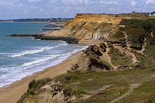
Poole Bay is a bay in the English Channel, on the coast of Dorset in southern England, which stretches 16 km from Sandbanks at the mouth of Poole Harbour in the west, to Hengistbury Head in the east. Poole Bay is a relatively shallow embayment and consists of steep sandstone cliffs and several 'chines' that allow easy access to the sandy beaches below. The coast along the bay is continuously built up, and is part of the South East Dorset conurbation, including parts of the towns of Poole, Bournemouth and Christchurch. The bay is sometimes referred to as Bournemouth Bay, because much of it is occupied by Bournemouth.
In geology, the Bagshot Beds are a series of sands and clays of shallow-water origin, some being fresh-water, some marine. They belong to the upper Eocene formation of the London and Hampshire basins, in England and derive their name from Bagshot Heath in Surrey. They are also well developed in Hampshire, Berkshire and the Isle of Wight. The following divisions are generally accepted:

The Bracklesham Group, in geology, is a series of clays and marls, with sandy and lignitic beds, in the middle Eocene of the Hampshire Basin and London Basin of England.

Palaeotherium is an extinct genus of perissodactyl ungulate known from the Mid Eocene to earliest Oligocene of Europe. First described by French naturalist Georges Cuvier in 1804, Palaeotherium was among the first Paleogene mammals to be described.
The Wealden Group, occasionally also referred to as the Wealden Supergroup, is a group in the lithostratigraphy of southern England. The Wealden group consists of paralic to continental (freshwater) facies sedimentary rocks of Berriasian to Aptian age and thus forms part of the English Lower Cretaceous. It is composed of alternating sands and clays. The sandy units were deposited in a flood plain of braided rivers, the clays mostly in a lagoonal coastal plain.

The Hampshire Basin is a geological basin of Palaeogene age in southern England, underlying parts of Hampshire, the Isle of Wight, Dorset, and Sussex. Like the London Basin to the northeast, it is filled with sands and clays of Paleocene and younger ages and it is surrounded by a broken rim of chalk hills of Cretaceous age.

Barbara Rawdon-Hastings, Marchioness of Hastings, 20th Baroness Grey de Ruthyn was a fossil collector and geological author.
Whitecliff Bay and Bembridge Ledges is a 131.6-hectare (325-acre) Site of Special Scientific Interest that lies around the coastline of the easternmost part of the Isle of Wight from the Bembridge harbour entrance in the north around Foreland to Whitecliff Bay to the south. The site was notified in 1955 for both its biological and geological features.
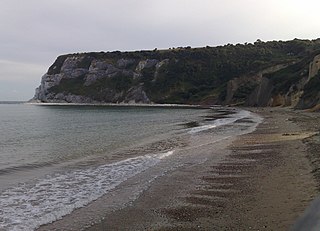
Whitecliff Bay is a sandy bay near Foreland which is the easternmost point of the Isle of Wight, England, about two miles south-west of Bembridge and just to the north of Culver Down. The bay has a shoreline of around three-quarters of a mile (1.2 km) and has a popular sandy shingle beach which is over half a mile long. It is a tourist site with three holiday parks in the vicinity of the bay; it has two cafes though minimal facilities. Access is limited and only possible down two steeply sloping concrete tracks.

The Wessex Formation is a fossil-rich English geological formation that dates from the Berriasian to Barremian stages of the Early Cretaceous. It forms part of the Wealden Group and underlies the younger Vectis Formation and overlies the Durlston Formation. The dominant lithology of this unit is mudstone with some interbedded sandstones. It is part of the strata of the Wessex Basin, exposed in both the Isle of Purbeck and the Isle of Wight. While the Purbeck sections are largely barren of vertebrate remains, the Isle of Wight sections are well known for producing the richest and most diverse fauna in Early Cretaceous Europe.
Homarus morrisi is a species of fossil lobster from the Eocene of southern England.
The Bouldnor Formation is a geological formation in the Hampshire Basin of southern England. It is the youngest formation of the Solent Group and was deposited during the uppermost Eocene and lower Oligocene.
The Thanet Formation is a geological formation found in the London Basin of southeastern England. It is of early to mid-Thanetian age and gave its name to that stratigraphic interval. It was previously known as the Thanet Beds, the Thanet Sands and the Thanet Sand Formation. It was named after the Isle of Thanet. The type sections are Herne Bay in Kent for the upper part of the formation and Pegwell Bay for the lower part. It lies unconformably on the Late Cretaceous Chalk Group. It unconformably underlies the Lambeth Group, generally the Upnor Formation but in Essex it is the Reading Formation.

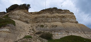
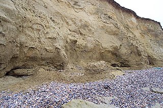
The Barton Group is a geological group found in the Hampshire Basin of Southern England. It ranges in age from Lutetian to Priabonian. It is exposed on the coast in southern Hampshire and in the northern part of the Isle of Wight. The type section is sea cliffs east of Christchurch, between Cliff End and Paddy's Gap.
Highcliffe to Milford Cliffs is a 110.1-hectare (272-acre) geological Site of Special Scientific Interest which stretches along the south coast of England from Christchurch in Dorset to Milford on Seain Hampshire. It includes several Geological Conservation Review sites.

