Beachy Head

Last updated

Beachy Head
Beachy Head Lighthouse under the cliff.jpg
Beachy Head Lighthouse under the cliff
East Sussex UK location map.svg
Red pog.svg
The cliff within East Sussex
Coordinates: 50°44′15″N00°14′51″E / 50.73750°N 0.24750°E / 50.73750; 0.24750
Location Eastbourne, East Sussex, England
Age Late Cretaceous, Cenozoic
Highest elevation162 m (531 ft)

Beachy Head is a chalk headland in East Sussex, England. It is situated close to Eastbourne, immediately east of the Seven Sisters.

Contents

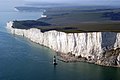
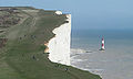
Beachy Head is located within the administrative area of Eastbourne Borough Council which owns the land, forming part of the Eastbourne Downland Estate. The cliff is the highest chalk sea cliff in Britain, rising to 162 m (531 ft) above sea level. The peak allows views of the south east coast towards Dungeness in the east, and to the Isle of Wight in the west.

LB&SCR H2 class 4-4-2 steam locomotive number 424 (later B424, 2424, and 32424) was named Beachy Head after this landmark.

Geology

The chalk was formed in the Late Cretaceous epoch, between 66 and 100 million years ago, when the area was under the sea. During the Cenozoic Era, the chalk was uplifted (see Cenozoic Era). When the last ice age ended, sea levels rose and the English Channel formed, cutting into the chalk to form the dramatic cliffs along the Sussex coast.

Wave action contributes to the erosion of cliffs around Beachy Head, which experience frequent small rock falls. Since chalk forms in layers separated by contiguous bands of flints, the physical structure affects how the cliffs erode. Wave action undermines the lower cliffs, causing frequent slab failures – slabs from layers of chalk break off, undermining the upper parts of the cliffs, which eventually collapse. [1] In contrast to small rock falls, mass movements are less common. A mass movement happened in 2001 when, after a winter of heavy rain, the water had begun to seep into the cracks which had frozen and caused the cracks to widen. This then made the cliff edge erode and collapse into the sea, destroying a well-known chalk stack called the Devil's Chimney. [2]

History

The name Beachy Head appears as 'Beauchef' in 1274, becoming 'Beaucheif' by 1317, and it has nothing to do with the word "beach". Instead, it is a corruption of the original French words meaning "beautiful headland" (beau chef). It was being consistently called Beachy Head by 1724. [3] [4]

In 1929, Eastbourne Borough Council bought 4,000 acres (1,600 hectares ) of land surrounding Beachy Head to save it from development at a cost of about £100,000 (equivalent to £6,467,710in 2021). [5] This land became known as the Eastbourne Downland Estate.[ citation needed ]

The prominence of Beachy Head has made it a landmark for sailors in the English Channel. It is noted as such in the sea shanty Spanish Ladies : [6]

The first land we sighted was called the Dodman,
Next Rame Head off Plymouth, off Portsmouth the Wight;
We sailed by Beachy, by Fairlight and Dover,
And then we bore up for the South Foreland light.

The ashes of German social scientist and philosopher Friedrich Engels, one of the fathers of communism, were scattered off the cliffs at Beachy Head into the Channel, as he had requested. [3]

Human remains discovered in the 1950s were subjected to forensic reconstruction, carbon dating, and radioisotype analysis, and it was concluded that they were those of a Roman woman of Sub-Saharan African origin who grew up in the Eastbourne area in about 200–250 CE. She became known as Beachy Head Lady. [7] [8] [9] However, in 2021, DNA testing indicated she was of "southern European lineage, most likely from Cyprus"; [10] the parish later ordered the removal of a plaque erected by the BBC "to commemorate the first black Briton." [11]

Lighthouse

Belle Tout Lighthouse Seven Sisters 3.jpg
Belle Tout Lighthouse

The headland has been considered a danger to shipping. In 1831, construction began on the Belle Tout Lighthouse on the next headland west from Beachy Head. Because mist and low clouds could hide the light of Belle Tout, it was decommissioned in 1902, after the Beachy Head Lighthouse had been built in the sea below Beachy Head as a replacement.

At war

The third day of fighting in the Battle of Portland in 1653 took place off Beachy Head during the First Anglo-Dutch War. The Battle of Beachy Head in 1690 was a naval engagement during the Nine Years' War. The so-called Second Battle of Beachy Head took place over a week in September 1916 during the First World War. Three German U-boats sank 30 merchant ships between Beachy Head and the Eddystone. This was despite a major effort involving the Royal Navy and 49 destroyers, 48 torpedo boats, seven 'Q' ships and 468 auxiliaries. [12]

During the Second World War, the Royal Air Force (RAF) established a forward relay station at Beachy Head to improve radio communications with aircraft. In 1942, signals were picked up at Beachy Head which were identified as TV transmissions from the Eiffel Tower. The Germans had reactivated the pre-war TV transmitter and instituted a Franco-German service for military hospitals and VIPs in the Paris region. The RAF monitored these programmes, hoping (in vain) to gather intelligence from newsreels. [13] The area had an important wartime radar station. During the Cold War, a radar control centre was operational in an underground bunker from 1953 to 1957. [3] On 20 May 1942, a Messerschmitt Bf 109 of JG26 piloted by Uffz. Oswald Fischer belly-landed on the beach due to flak damage. Fischer was taken prisoner, and the relatively undamaged plane was sent to RAE Farnborough for examination and evaluation. The plane was probably scrapped at the end of the war. [14]

Tourism

West from Belle Tout, the cliffs drop down to Birling Gap, then ascend through the Seven Sisters chalk cliffs to Haven Brow, overlooking the Cuckmere valley. The area is a popular tourist attraction. Birling Gap has a restaurant and, in the summer, multiple ice cream vans serve the area. There are many choices of walking routes.

Suicides

Phone box and sign advertising the Samaritans at Beachy Head. Beachy Head suicide phone.jpg
Phone box and sign advertising the Samaritans at Beachy Head.

Estimates of the number of annual deaths at Beachy Head vary from 20 a year to many more. [15] In 2010, it was the third most common suicide spot in the world, after the Golden Gate Bridge in San Francisco and the Aokigahara Woods in Japan, according to The Wall Street Journal . [16]

The Beachy Head Chaplaincy Team conducts regular day and evening patrols of the area in attempts to locate and stop potential cliff jumpers. Workers at the pub and taxi drivers are also on the lookout for people contemplating suicide and there are signs with the telephone number of the Samaritans urging potential jumpers to call them. [17]

Deaths at the site are often covered by the media, [18] and Ross Hardy, the founder of the chaplaincy team, has said that this encourages suicidal people to choose the site. [17] Eastbourne Borough Council drew media coverage in 2018 for its policy of removing shrines and crosses left at Beachy Head by families of suicide victims. [19]

The earliest reports of deaths by suicide at Beachy Head come from the 7th century. Between 1965 and 1979, there were 124 deaths at the location. Of these, S. J. Surtees wrote that 115 of them were "almost certainly" suicides (although a coroner's verdict of suicide was recorded in only 58 cases), and that 61 percent of the victims were from outside East Sussex. [18] After a steady increase in deaths between 2002 and 2005, there were only seven fatalities in 2006, a marked decrease. [20] The Maritime and Coastguard Agency, whose Coastguard Rescue Teams are responsible for the rescue of injured jumpers and the recovery of the dead, attributed the reduction to the work of the Chaplaincy Team and good coverage of services by the local media. [20] [21] At least 26 people died at the site in 2008. [22]

Use in entertainment and media

In film

The location Beachy Head has appeared in numerous films:

In literature and publications

In music

In television

In technology

A photo of Beachy Head [29] was used as a desktop wallpaper on Windows 7. [30]

Related Research Articles

<span class="mw-page-title-main">Mad Jack Fuller</span>

John Fuller, better known as "Mad Jack" Fuller, was Squire of the hamlet of Brightling, in Sussex, and politician who sat in the House of Commons between 1780 and 1812. He was a builder of follies, philanthropist, patron of the arts and sciences, and slave owner and a supporter of slavery. He purchased and commissioned many paintings from J. M. W. Turner. He was sponsor and mentor to Michael Faraday.

<span class="mw-page-title-main">The Needles</span> Sea stacks off the Isle of Wight, England

The Needles are a row of three stacks of chalk that rise about 30 metres (98 ft) out of the sea off the western extremity of the Isle of Wight in the English Channel, United Kingdom, close to Alum Bay and Scratchell's Bay, and part of Totland, the westernmost civil parish of the Isle of Wight. The Needles Lighthouse stands at the outer, western end of the formation. Built in 1859, it has been automated since 1994. The waters and adjoining seabed form part of the Needles Marine Conservation Zone and the Needles along with the shore and heath above are part of the Headon Warren and West High Down Site of Special Scientific Interest.

<span class="mw-page-title-main">Flamborough Head</span> Promontory in Yorkshire, United Kingdom

Flamborough Head is a promontory, 8 miles (13 km) long on the Yorkshire coast of England, between the Filey and Bridlington bays of the North Sea. It is a chalk headland, with sheer white cliffs. The cliff top has two standing lighthouse towers, the oldest dating from 1669 and Flamborough Head Lighthouse built in 1806. The older lighthouse was designated a Grade II* listed building in 1952 and is now recorded in the National Heritage List for England, maintained by Historic England. The cliffs provide nesting sites for many thousands of seabirds, and are of international significance for their geology.

<span class="mw-page-title-main">Seven Sisters, East Sussex</span> Series of chalk cliffs in Sussex, United Kingdom

The Seven Sisters are a series of chalk sea cliffs on the English Channel coast, and are a stretch of the sea-eroded section of the South Downs range of hills, in the county of East Sussex, in south-east England. The Seven Sisters cliffs run between the mouth of the River Cuckmere near Seaford, and the chalk headland of Beachy Head outside of Eastbourne. The dips or swales that separate each of the seven crests from the next are the remnants of dry valleys in the chalk South Downs which are being gradually eroded by the sea.

<span class="mw-page-title-main">South Downs Way</span> Long-distance footpath in the south of England

The South Downs Way is a long distance footpath and bridleway running along the South Downs in southern England. It is one of 16 National Trails in England and Wales. The trail runs for 160 km (100 mi) from Winchester in Hampshire to Eastbourne in East Sussex, with about 4,150 m (13,620 ft) of ascent and descent.

<span class="mw-page-title-main">South Downs</span> Range of chalk hills in southeast England

The South Downs are a range of chalk hills in the south-eastern coastal counties of England that extends for about 260 sq mi (670 km2) across the south-eastern coastal counties of England from the Itchen valley of Hampshire in the west to Beachy Head, in the Eastbourne Downland Estate, East Sussex, in the east. The Downs are bounded on the northern side by a steep escarpment, from whose crest there are extensive views northwards across the Weald. The South Downs National Park forms a much larger area than the chalk range of the South Downs, and includes large parts of the Weald.

<span class="mw-page-title-main">South Downs National Park</span> National park in South East England

The South Downs National Park is England's newest national park, designated on 31 March 2010. The park, covering an area of 1,627 square kilometres (628 sq mi) in southern England, stretches for 140 kilometres (87 mi) from Winchester in the west to Eastbourne in the east through the counties of Hampshire, West Sussex and East Sussex. The national park covers the chalk hills of the South Downs and a substantial part of a separate physiographic region, the western Weald, with its heavily wooded sandstone and clay hills and vales. The South Downs Way spans the entire length of the park and is the only National Trail that lies wholly within a national park.

<span class="mw-page-title-main">White Cliffs of Dover</span> English cliff shore

The White Cliffs of Dover are the region of English coastline facing the Strait of Dover and France. The cliff face, which reaches a height of 350 feet (110 m), owes its striking appearance to its composition of chalk accented by streaks of black flint, deposited during the Late Cretaceous. The cliffs, on both sides of the town of Dover in Kent, stretch for eight miles (13 km). The White Cliffs of Dover form part of the North Downs. A section of coastline encompassing the cliffs was purchased by the National Trust in 2016.

<span class="mw-page-title-main">Bempton Cliffs</span> RSPB nature reserve in the East Riding of Yorkshire, England

Bempton Cliffs is a section of precipitous coast at Bempton in the East Riding of Yorkshire, England. It is run by the RSPB as a nature reserve and is known for its breeding seabirds, including northern gannet, Atlantic puffin, razorbill, common guillemot, black-legged kittiwake and fulmar. There is a visitor centre.

<span class="mw-page-title-main">White Nothe</span> Headland in Dorset, England

White Nothe is a chalk headland on the English Channel coast at the eastern end of Ringstead Bay, east of Weymouth in Dorset, England. The area is well known for its geology and fossils. Its flanks are the result of prehistoric landslides and the inaccessible slopes of the undercliff provide a secluded wildlife habitat.

<span class="mw-page-title-main">East Dean and Friston</span> Human settlement in England

East Dean and Friston is a civil parish in the Wealden District of East Sussex, England.The two villages in the parish are in a dry valley on the South Downs – between Eastbourne three miles (4.8 km) to the east and Seaford an equal distance to the west. The main A259 road goes through both village centres. The coast and much of the land between it and the A259 from the east edge of Seaford to the west edge of Eastbourne is owned by the National Trust, and this has prevented further development to the area. The civil parish was formed on 1 April 1999 from "East Dean" and "Friston" parishes.

<span class="mw-page-title-main">Beachy Head Lighthouse</span> Lighthouse at Beachy Head, East Sussex, England

Beachy Head Lighthouse is a lighthouse located in the English Channel below the cliffs of Beachy Head in East Sussex. It is 33 m (108 ft) in height and became operational in October 1902. It was the last traditional-style 'rock tower' to be built by Trinity House.

<span class="mw-page-title-main">Belle Tout Lighthouse</span> Lighthouse at Beachy Head, East Sussex, England

The Belle Tout Lighthouse is a decommissioned lighthouse and British landmark located at Beachy Head, East Sussex, close to the town of Eastbourne. It has been called "Britain's most famous inhabited lighthouse" because of its striking location and use in film and television. In 1999, the Grade II listed building was moved in one piece to prevent it from succumbing to coastal erosion.

RAF Beachy Head is a former Royal Air Force radar station and one of the many Chain Home Low radar stations, being situated near Beachy Head and Eastbourne in East Sussex, England. It featured a Type 16 radar that was monitored from RAF Kenley.

<span class="mw-page-title-main">Eastbourne</span> Town in East Sussex, England

Eastbourne is a town and seaside resort in East Sussex, on the south coast of England, 19 miles (31 km) east of Brighton and 54 miles (87 km) south of London. It is also a local government district with borough status. Eastbourne is immediately east of Beachy Head, the highest chalk sea cliff in Great Britain and part of the larger Eastbourne Downland Estate.

<span class="mw-page-title-main">Eastbourne Lifeboat Station</span> RNLI Lifeboat Station in East Sussex, England

Eastbourne Lifeboat Station is a Royal National Lifeboat Institution (RNLI) lifeboat station in the town of Eastbourne in East Sussex. Founded two years before the RNLI was established, the station has operated continuously since 1822 and its lifeboats have been responsible for saving over 700 lives. There are two active lifeboat stations in Eastbourne, an all-weather station with the Trent-class 14-02 Esme Anderson at Sovereign Harbour and the D-class (IB1) The David H (D-876) at the inshore lifeboat station a couple of miles to the west at Fisherman's Green. An older lifeboat station, west of Eastbourne Pier, is now used as an RNLI museum.

<span class="mw-page-title-main">Eastbourne Downland Estate</span>

The Eastbourne Downland Estate is an area of downland at the easternmost end of the South Downs National Park in East Sussex, England. It was bought by the public, following threats to the beauty spots of Beachy Head and the surrounding farmland, which led to a public campaign and Act of Parliament in 1926. It is currently owned and managed, on behalf of the public, by Eastbourne Borough Council.

On 27 August 2017, Beachy Head and beaches including Birling Gap, in the English county of East Sussex, were evacuated following a suspected chemical leak. Visitors reported ill effects after the appearance of a "mist", and 233 people were treated at Eastbourne General Hospital, initially with a full chemical decontamination. Witnesses reported stinging and dried-up eyes, regardless of repeated eyewashes.

The Life and Loves of a She-Devil is a 1986 award-winning BBC drama serial adapted from Fay Weldon's 1983 novel The Life and Loves of a She-Devil. Fay Weldon's novel was later filmed as the 1989 US comedy film She Devil.

References

  1. "ALAN MACKENZIE".
  2. Cold, wet winter blamed for cliff collapse at Beachy Head, Michael McCarthy, The Independent, 5 April 2001 (retrieved 4 September 2020)
  3. 1 2 3 Surtees, Dr John (1997). Beachy Head. Seaford: SB Publications. ISBN   978-1-85770-118-0.
  4. Ekwall, Eilert (1960). The Concise Oxford Dictionary of English Place-names (4th ed.). Oxford: Oxford University Press. ISBN   978-0-19-869103-7.
  5. Times, 30 October 1929. P. 11
  6. Palmer, Roy (1986). The Oxford Book of Sea Songs . Oxford: Oxford University Press. ISBN   978-0-19-214159-0.
  7. Miller, Ben (28 March 2014). "Beachy Head Lady was young sub-Saharan Roman with good teeth, say archaeologists – Culture24". Archived from the original on 30 January 2018. Retrieved 21 February 2017.
  8. "Centuries-old Beachy Head Lady's face revealed – BBC News". BBC Online . 1 February 2014. Retrieved 21 February 2017.
  9. Mintz, Zoe (4 February 2014). "Face Of 'Beachy Head Lady' Revealed, Roman Era Woman Is A 'Fantastic Discovery'". International Business Times . Retrieved 21 February 2017.
  10. "Story of Eastbourne celebrates first year with 23,000 visitors". 27 February 2020. Retrieved 12 November 2020.
  11. Jack Blackburn (26 October 2023). "Plaque for first black Briton is shelved (she was from Cyprus)". The Times . Retrieved 26 October 2023. Parish councillors in the village of East Dean in East Sussex voted to remove the plaque
  12. Reagan, Geoffrey. Military Anecdotes (1992) pp. 118 & 119, Guinness Publishing ISBN   0-85112-519-0
  13. Ockenden, Michael (April 1983). "TV Pictures from Occupied Paris". After the Battle. Battle of Britain Prints International (39).
  14. Jackiewicz, Jacek (2007). Captured Me-109's. Poland: Atelier Kecay. p. 177. ISBN   9788392491408.
  15. "Suicide jump child 'already dead'". BBC News Online. BBC. 2 June 2009. Retrieved 2 June 2009.
  16. Meaney, Thomas (15 April 2006). "Exiting Early". The Wall Street Journal. Retrieved 16 November 2010.
  17. 1 2 Leitch, Luke. "Beachy Head: no ordinary beauty spot". The Times. 3 June 2009. Accessed 10 August 2011.
  18. 1 2 Surtees, S. J. "Suicide and accidental death at Beachy Head." (subscription required). British Medical Journal 284 (6312): 321–324. 30 January 1982.
  19. "Council bans families of suicide victims from leaving shrines at Beachy Head". The Telegraph. 23 May 2018.
  20. 1 2 "Beachy Head suicide numbers down". BBC News Online. BBC. 20 December 2006. Retrieved 2 June 2009.
  21. "Beachy Head Press Release". MCA Press Release. UK Maritime and Coastguard Agency. Archived from the original on 27 September 2007. Retrieved 2 June 2009.
  22. Smyth, Chris. "Man, woman and child found at foot of Beachy Head". The Times. 2 June 2009. Accessed 10 August 2011.
  23. "The Living Daylights (1987)" via www.imdb.com.
  24. "Fantastic Beasts: The Crimes of Grindelwald at the Seven Sisters – filming location".
  25. 'Nature Near London' by Richard Jefferies was published by Chatto and Windus, in April 1883.
  26. "The Fox by Nada Surf Songfacts". www.songfacts.com.
  27. "New series of Luther comes to Beachy Head". www.eastbourneherald.co.uk. Archived from the original on 1 October 2017. Retrieved 9 February 2016.
  28. "Black Mirror Season 2, Episode 1". www.culturefly.com. 15 February 2013.
  29. "Beachy Head: England's Most Spectacular White Cliffs". Passport Collective. 4 October 2018. Retrieved 13 November 2019.
  30. Trenholm, Richard. "Windows 7 world tour wallpapers". CNET. Retrieved 27 January 2021.