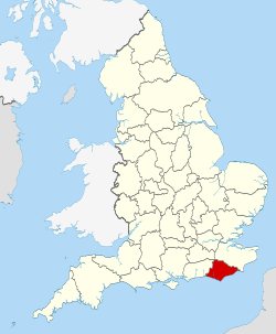
The county has an area of 1,792km2 (692sqmi) and had an estimated population of 844,752 in 2024. The largest settlements are on the coast,and include Brighton and Hove in the south-west,Eastbourne in the south,and Hastings in the south-east. Away from the coast the county is largely rural,and its settlements include Crowborough in the north,Hailsham in the south-centre,and Lewes in the west. For local government purposes East Sussex comprises a non-metropolitan county,with five districts,and the unitary authority of Brighton and Hove. East Sussex and West Sussex historically formed a single county,Sussex.
The north east of East Sussex is part of the Weald,a sandstoneanticline that was once an extensive woodland. The highest point in this area is Crowborough Hill (242m (794ft)),part of the High Weald uplands. The south west of the county is part of the South Downs,a rolling chalkescarpment that stretches west into West Sussex and Hampshire. Ditchling Beacon (248m (814ft)) is the highest point. Where the downs reach the sea,they form high cliffs such as the Seven Sisters,where eroded dry valleys create an undulating skyline.[5] The county does not contain large rivers,but its largest are the Rother,which forms part of the boundary with Kent,the Cuckmere,and the Ouse,which rises in West Sussex and flows through Lewes before reaching the English Channel at Newhaven.[6]
East Sussex is part of the historic county of Sussex,which has its roots in the ancient kingdom of the South Saxons,who established themselves there in the 5th century AD,after the departure of the Romans. Archaeological remains are plentiful,especially in the upland areas. The area's position on the coast has also meant that there were many invaders,including the Romans and later the Normans,following the defeat of the English army by William the Conqueror at the Battle of Hastings in 1066.[7][8] Earlier industries included fishing,iron-making,and the wool trade,all of which have declined or been lost completely.
Geologically,East Sussex is part of southern anticline of the Weald:the South Downs,a range of moderate chalk hills which run across the southern part of the county from west to east and mirrored in Kent by the North Downs. To the north lie parallel valleys and ridges,the highest of which is the Weald itself (the Hastings beds and Wealden Clay). The sandstones and clays meet the sea at Hastings;the Downs,at Beachy Head. The area contains significant reserves of shale oil,totalling 4.4 billion barrels of oil in the Wealden basin according to a 2014 study,which then Business and Energy Minister Michael Fallon said "will bring jobs and business opportunities" and significantly help with UK energy self-sufficiency. Fracking in the area is required to achieve these objectives,which has been opposed by environmental groups.[13]
East Sussex,like most counties by the south coast,has an annual average total of around 1,750[14] hours of sunshine per year. This is much higher than the UK's average of about 1,340 hours of sunshine a year.
Relief and drainage
The relief of the county reflects the geology.
The chalk uplands of the South Downs occupies the coastal strip between Brighton and Eastbourne. There are two river gaps:the Rivers Ouse and Cuckmere. The Seven Sisters,where the Downs meet the sea,are the remnants of dry valleys cut into the chalk;they end at Beachy Head,530feet (162m) above sea level. To the east of Beachy Head lie the marshlands of the Pevensey Levels,formerly flooded by the sea but now enclosed within a deposited beach. At Bexhill the land begins to rise again where the sands and clays of the Weald meet the sea;these culminate in the sandstone cliffs east of Hastings. Further east are the Pett Levels,more marshland,beyond which is the estuary of the River Rother. On the far side of the estuary are the dunes of Camber Sands. The highest point in the county is Ditchling Beacon on the South Downs,which has a maximum elevation of 248m (814ft)[15] and is classed as a Marilyn.
The Weald occupies the northern borderlands of the county. Between the Downs and Weald is a narrow stretch of lower lying land;many of the rivers and streams occupying this area originate in the Weald. The High Weald is heavily wooded in contrast to the South Downs;the Low Weald less so. Part of the Weald is the Ashdown Forest.
The location of settlements in East Sussex has been determined both by its history and its geography. The original towns and villages tended to be where its economy lay:fishing along the coast and agriculture and iron mining on the Weald. Industry today tends to be geared towards tourism,particularly along the coastal strip where towns such as Bexhill-on-Sea,Eastbourne,and Hastings are located. Newhaven and Rye are ports,although the latter is also of historical importance. Peacehaven and Seaford serve as dormitory towns. Away from the coast are former market towns such as Hailsham,Heathfield and Uckfield;Crowborough is a centre for the Ashdown Forest. Lewes,the County town of East Sussex;Battle,with its Norman Conquest beginnings,and Wadhurst are the other three towns of significance.
Measured by the number of registered companies,East Sussex is not a major manufacturing or industrial area of the United Kingdom. Of the companies registered,the leading category in 2023 was "construction",followed by "real estate activities".[18] An important contribution to the county's economy comes from the fact that many residents of Brighton and Hove,Eastbourne and Hastings commute to London or work remotely for companies outside the county.[19]
There were 1,720 agricultural holdings in East Sussex (excluding Brighton and Hove) in 2022,with a total farmed area of 108,825 hectares. They employed just over 4000 people and,in 2020,produced a gross value added of £66 million. Livestock grazing accounts for almost 40% of the farmed area,with there being approximately six times as many sheep as cattle.[20] Fishing is limited but there are still fishing fleets,notably at Rye and Hastings,although the number of boats is much reduced. Historically,the fisheries were of great importance.
Landmarks
Mermaid Street in Rye showing typically steep slope and cobbled surface
East Sussex has no motorways,and even dual carriageways are sparse in the county. The main roads through the county are those part of the radial pattern from London:the A21 from Kent to Hastings;the A22 from Surrey to Eastbourne;and the A23 from Gatwick to Brighton. Cross-country routes include the A26 which carries traffic from Newhaven and Lewes north into Kent;and the south coast trunk route,which starts in Folkestone (Kent) as the A259 trunk road,and traverses the south coast to Eastbourne,where it becomes the A27 trunk road and heads westwards towards Chichester in West Sussex and ultimately to Honiton in Devon. The county's main roads suffer from congestion and traffic problems,particularly the A27,which connects Eastbourne with Portsmouth.[22][23]
Bus routes serve all the main areas of settlement and many of the villages in the county.
There are no airports offering scheduled flights in East Sussex. London's second airport,Gatwick Airport,is a short distance from East Sussex and easily accessible by road and rail from most of the county. Despite its name,Brighton City Airport,the former Shoreham Airport,is in West Sussex. Three airfields service general aviation,helicopters and flying schools:Spilsted Farm near Hastings;[25] Kittyhawk Aerodrome near Lewes;,[26] and Deanland Airfield,also near Lewes.[27] Sussex Gliding Club operate from Kitsons field at The Broyle on the outskirts of Ringmer.[28]
Ferries
A ferry operates from Newhaven to Dieppe in France twice daily in the off-season and three times daily in the summer. Both vehicles and foot passengers are accepted.[29]
Over 150 primary schools serve the area;many of them small and local in scope.
State and independent secondary schools include Lewes Old Grammar School,which celebrated its 500th anniversary in 2012. Overall,more than 50 serve East Sussex,including further education colleges in larger towns.
A number of independent boarding schools that also cater to day students are located in the county,including Brighton College and Roedean. The Pestalozzi Children's Village,an international foundation,is located at Sedlescombe.
The county's coastal towns,including Brighton and Hove,Bexhill-on-Sea,Hastings and Eastbourne,are popular visitor destinations,particularly in summer. Brighton and Hove have a range of attractions including the Royal Pavilion. Beginning in 1787,it was built in three stages as a seaside retreat for George,Prince of Wales,who became King George IV in 1820. A more recent attraction is the Brighton i360,a 162 m observation tower on the seafront.[33]
Brighton Palace Pier,Eastbourne Pier and Hastings Pier serve as entertainment centres that attract many visitors. Several other piers built in the heyday of day tripper visits by train no longer exist,including St Leonards Pier,in St Leonards-on-Sea,and the West Pier in Brighton,parts of which can still be seen in the sea opposite the Brighton i360. Originally,the profits from the i360 were seen as a potential source of funds to rebuild the West Pier,but that now seems unlikely.[34] Other important tourist attractions within East Sussex include Ashdown Forest,Drusillas Zoo Park near Alfriston and Michelham Priory. The county has two narrow-gauge railways,the Hastings Miniature Railway,which is powered by a steam locomotive,and Volk's Electric Railway,which runs from Brighton's Palace Pier to Brighton Marina along the seafront. Volk's is the oldest operational electric railway in the world. There are also several castles that attract many visitors,as indicated in the Landmarks section above.
A 1903 De Dion-Bouton arrives in Brighton in the 2012 Veteran Car Run
Annual events also promote tourism to the county. Brighton Pride is one of the UK's largest and oldest pride parades and other pride events take place at Eastbourne and Hastings.[35][36] The London to Brighton Veteran Car Run is the world's longest-running motoring event. To qualify,cars must have been built before 1905. It is also the world's largest gathering of veteran cars. The race finishes on Madeira Drive in Brighton.[37]
The Lewes Bonfire is a set of bonfire celebrations held on Guy Fawkes Night,which both celebrates the uncovering of the Gunpowder Plot in 1605 and commemorates the memory of the seventeen Protestant martyrs from Mayfield burned at the stake between 1555 and 1557. It has a history of religious antagonism and anti-Catholic imagery,including the burning of an effigy of the Pope. The event attracts tens of thousands of spectators every year. There are also many other bonfire societies in East Sussex.[38]
Sport
Football
The Dripping Pan,home of Lewes FC men's and women's teams
Cricket had its origins in the counties of Kent,Surrey and Sussex. There is no team representing East Sussex. It combines with West Sussex as the Sussex County Cricket Club,playing first-team matches at the County Ground in Hove and reserve-team matches in both East and West Sussex. There are around 25 local clubs playing the game in East Sussex.[39]
Rugby
There are around 15 rugby clubs in East Sussex,with many of them fielding several teams including women's and girls' teams. Seaford Rugby Club claims the distinction of playing its home games below sea level.[40]
Cycling
The fourth stage of the 1994 Tour de France ended in Brighton after departing from Dover. The route included a climb over Ditchling Beacon.[41] The hilly nature of the Downs presents a good challenge for cyclists and there are at least eight cycling clubs in East Sussex.[42]
Golf
There are 42 golf courses in East Sussex,many on downland. Four of these (two in Brighton and Hove,one in Eastbourne and one in Crowborough) are public courses;the remainder private,semi-private or resorts.[43]
Other sports
Other popular sports include sailing,bowls,stoolball,and tennis.
This page is based on this Wikipedia article Text is available under the CC BY-SA 4.0 license; additional terms may apply. Images, videos and audio are available under their respective licenses.