The district was formed on 1 April 1974, under the Local Government Act 1972, covering the area of six former districts, which were abolished at the same time:[2]
The two Wallingford districts had previously been part of the administrative county of Berkshire, whilst the other four districts had been in the administrative county of Oxfordshire. The new district was originally given the name "Wallingford".[3] The shadow authority elected in 1973 to oversee the transition requested a change of name to "South Oxfordshire", which was approved by the government before the new district formally came into being in 1974.[4]
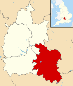
Geography
The River Thames flows for approximately 47 miles through South Oxfordshire,[5] forming the historic county boundary between Berkshire and Oxfordshire. It is also joined by the River Thame within the district. A characteristic of the rivers within the district is that they have wide floodplains with few houses on them so that fluvial flooding is a lesser problem than flash flooding.[6] Towns in the district are Didcot, Henley-on-Thames, Thame, Wallingford and Watlington.
The 2001 Census recorded a population of just over 128,000 in the district. This was an increase of 7% since 1991. By the 2021 Census, the figure had risen to over 149,000.[7]
Much of the district is rural in nature, with the land in agricultural use and around 70% of the district has a green belt or AONB designation (The northeast of the district forms part of the Oxford Green Belt). 50% of the district's population lives outside its four main towns of Didcot, Henley-on-Thames, Thame and Wallingford.
The Liberal Democrats have held a majority of the seats on the council since the 2023 election.[13] Despite having a majority, they at first continued a coalition with the Green Party that they had formed after the 2019 election.[14][15] However, in May 2025 the Liberal Democrat group chose to end the coalition with the Greens and take full control.[16]
The first election to the district council was held in 1973, initially operating as a shadow authority alongside the outgoing authorities until it came into its powers on 1 April 1974. Political control of the council since 1974 has been as follows:[17]
Since the last full review of boundaries in 2015, the council has comprised 36 councillors representing 21 wards, with each ward electing one, two or three councillors. Elections are held every four years.[27]
Premises
The council was initially based in various premises across the district in Henley, Thame, Wheatley, Wallingford and Didcot inherited from its predecessor authorities.[28] In 1981 the council moved to a purpose-built headquarters on Benson Lane, Crowmarsh Gifford, near Wallingford.[29]
On 15 January 2015, an arson attack destroyed the district council's main offices in Crowmarsh Gifford.[30] As the fire started in the early hours of the morning there were no fatalities or injuries.[31] Immediately after the fire, the council was temporarily based in Abingdon, in the neighbouring Vale of White Horse district.[32] From later in 2015 until 2022 the council was based at Milton Park, sharing a building with Vale of White Horse District Council.[33] The Council initially intended to return to Crowmarsh,[34] but in October 2020 it was announced that both councils plan on relocating to a new building in Didcot, to be built on a site known as Didcot Gateway opposite Didcot Parkway railway station, aiming for completion in 2023.[35] In 2022 the councils vacated Milton Park and returned to Abingdon, again on a temporary basis, whilst waiting for the Didcot Gateway scheme to be ready.[36] In July 2025, the council decided to stop any new work on the Didcot Gateway project because of the impending Local Government Reorganisation.[37][38]
South Oxfordshire has consistently one of the best recycling rates in England, coming top of the league table of the percentage of waste sent for recycling, reuse or composting in 2022/23[41] and 2023/24, with 62.9% of waste now recycled.[42] The local authority has been placed at or near the top of the league table for over a decade.[43]
Energy consumption
In May 2006, a report commissioned by British Gas[44] showed that housing in South Oxfordshire produced the 5th highest average carbon emissions in the country at 7,356kg of carbon dioxide per dwelling.
↑ "Compositions Calculator". The Elections Centre. University of Exeter. Retrieved 26 November 2024. (Put "South Oxfordshire" in search box to see specific results.)
↑ 1975 Telephone Directory, South Oxfordshire District Council: Headquarters at St George's House, Wallingford, area offices at West Hill House, Henley / Stone Hall, High Street, Wallingford / Churchill House, Broadway, Didcot / London Road, Wheatley.
This page is based on this Wikipedia article Text is available under the CC BY-SA 4.0 license; additional terms may apply. Images, videos and audio are available under their respective licenses.