Brightwell-cum-Sotwell

Last updated

Brightwell-cum-Sotwell
Villages and civil parish
Brightwell StAgatha exterior.JPG
St Agatha's parish church
Oxfordshire UK location map.svg
Red pog.svg
Brightwell-cum-Sotwell
Location within Oxfordshire
Area13.17 km2 (5.08 sq mi)
Population1,538 (2011 census) [1]
  Density 117/km2 (300/sq mi)
OS grid reference SU5890
Civil parish
  • Brightwell-cum-Sotwell
District
Shire county
Region
Country England
Sovereign state United Kingdom
Post town Wallingford
Postcode district OX10
Dialling code 01491
Police Thames Valley
Fire Oxfordshire
Ambulance South Central
UK Parliament
Website Brightwell-cum-Sotwell Website
List of places
UK
England
Oxfordshire
51°36′46″N1°09′46″W / 51.6129°N 1.1629°W / 51.6129; -1.1629

Brightwell-cum-Sotwell is a twin-village and civil parish in the Upper Thames Valley in South Oxfordshire. It lies between Didcot to the west and the historic market town of Wallingford to the east. In 1974 it was transferred from Berkshire to the county of Oxfordshire, and from Wallingford Rural District to the district of South Oxfordshire.

Contents

History

Brightwell and Sotwell were originally two separate villages, rural settlements whose inhabitants worked the land.

Prehistory

For thousands of years hunter-gatherers of the Thames Valley would have passed this way, stalking wild animals and gathering from the trees that grew on the greens and in this area. This good soil and the abundant water supply may have encouraged Iron Age farmers (1500 BC - AD 50) to settle in this area. The ramparts on Wittenham Clumps provide enduring evidence of Iron Age settlement in the area.

Roman

Evidence of a Roman road dating from about 43 CE, has been uncovered under the playing fields of the local primary school. Other finds include Roman coins and pottery. [2]

Medieval times

The first written evidence of a village here comes from the various Saxon charters describing ownership of land in Beorhtanville, Suttanwille and Maccanie. In a charter of 854 Æthelwulf, King of Wessex granted Swithun, Bishop of Winchester, an estate of 30 hides at Brihtanwylle to help the bishop pay the expenses of entertaining distinguished foreign guests. [3] Subsequently, William the Conqueror’s agents recorded in the Domesday Book in 1086 70 families and two mills in Brightwell and Sotwell, but where the mills stood and how they were powered is unknown. Within 50 years of Domesday, Brightwell Castle was involved in the civil war between King Stephen and his cousin Matilda. The exact site of this castle is unknown, but it probably lay within the moated areas of what later contained St Agatha's/Brightwell manor house in Brightwell or Stonor Hayes manor house in Sotwell.

Early modern times

Brightwell Inclosure Act 1811
Act of Parliament
Coat of Arms of the United Kingdom (1801-1816).svg
Long title An Act for allotting and inclosing Lands in the Parish of Brightwell, in the County of Berks.
Citation 51 Geo. 3. c. lxxxiii
Dates
Royal assent 14 May 1811
Text of statute as originally enacted

For the next 800 years Brightwell and Sotwell parishes only occasionally appear in recorded history. For example:

With the coming of the Industrial Revolution and the Victorian era, the village had some significant philanthropists who worked hard for the good of the villagers:

Modern times

The War Memorial records the loss of villagers in the armed services in the two world wars. In the second half of the 20th century there was significant expansion of the villages and in 1948 the villages of Brightwell and Sotwell were brought together as one civil parish. In 1949 the Greenmere estate was built and later, estates were also built at Kings Orchard, Monks Mead and Datchet Green. There are no immediate plans for any major development, though around 2011 there was some controversy regarding a plan to build some 800 houses between the village and Wallingford. The plan to develop on this area was eventually abandoned, in the face of local pressure, in favour of a new development on the Hithercroft. [5]

Notable buildings and structures

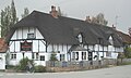
A walk around the narrow village streets will reveal many houses still standing which date back to Tudor times and beyond. The oldest building is probably Woodleys (Old Nursery Lane), with other examples such as Dobson's (Sotwell Street), The Old Priory (Little Lane), Middle Farm and Abbots House (both Church Lane - formerly Great Lane) and Smalls House (Mackney). Brightwell Manor is a Grade II listed building, with a mid 17th-century half-timbered structure extended by an 18th-century stone frontage. [6]

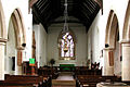
The Church of England parish churches of St Agatha (Brightwell) and St James (Sotwell) would have been at the centre of village affairs, surrounded by many thatched cottages with cob, or wattle and daub, walls. The original building dates back to the 12th century, the tower was rebuilt in about 1797. The church was restored in the 19th century, with an organ chamber added in about 1903. [7]

Notable residents

Related Research Articles

<span class="mw-page-title-main">Wallingford, Oxfordshire</span> Town in Oxfordshire, England

Wallingford is a historic market town and civil parish on the River Thames in South Oxfordshire, England, 12 miles (19 km) north of Reading, 13 miles (21 km) south of Oxford and 11 miles (18 km) north west of Henley-on-Thames. Although belonging to the historic county of Berkshire, it is within the ceremonial county of Oxfordshire for administrative purposes as a result of the 1972 Local Government Act. The population was 11,600 at the 2011 census.

<span class="mw-page-title-main">Blewbury</span> Human settlement in England

Blewbury is a village and civil parish at the foot of the Berkshire Downs section of the North Wessex Downs about 4 miles (6.4 km) south of Didcot, 14 miles (23 km) south of Oxford and 50 miles (80 km) west of London. It was part of Berkshire until the 1974 boundary changes transferred it to Oxfordshire. The 2011 Census recorded the parish's population as 1,581. A number of springs rise at the foot of the escarpment of the downs. Some springs feed a small lake called the Watercress Beds, where watercress used to be grown. From here and elsewhere tributaries feed the Mill Brook which carries the water to the river Thames at Wallingford. The A417 road runs along below the escarpment above the springs and through the south of the village. The Blewbury citizens are often called Blewbarians.

<span class="mw-page-title-main">Cholsey</span> Human settlement in England

Cholsey is a village and civil parish immediately south of Wallingford in South Oxfordshire. Its population in 2011 was 3,457. 2011 Census. Its parish boundary, some 17 miles (27 km) long, reaches from the edge of Wallingford into the Berkshire Downs. The village green called "The Forty" has a substantial and ancient walnut tree.

<span class="mw-page-title-main">Berrick Salome</span> Human settlement in England

Berrick Salome is a village and civil parish in South Oxfordshire, England, about 3 miles (5 km) north of Wallingford. Since the 1992 boundary changes, the parish has included the whole of Roke and Rokemarsh and Berrick Prior. The 2011 Census recorded the parish's population as 326. In 1965, Reginald Ernest Moreau (1897–1970), an eminent ornithologist, and a Berrick Salome resident from 1947, realized that he could build up a picture of the village as it had been in the decades before the First World War, based on the recollections of elderly villagers. His study, which was published in 1968 as The Departed Village: Berrick Salome at the Turn of the Century, also included an introduction to local history. This provided much of the information for "A Village History" which appeared in The Berrick and Roke Millennium Book and is the major source for this article.

<span class="mw-page-title-main">James Haldane Stewart</span>

James Haldane Stewart was rector of Limpsfield, Surrey, where he lies buried.

<span class="mw-page-title-main">Drayton, Vale of White Horse</span> Village in Oxfordshire, England

Drayton is a village and civil parish about 2 miles (3 km) south of Abingdon, Oxfordshire. It was part of Berkshire until the 1974 boundary changes transferred it to Oxfordshire. The parish includes the hamlet of Sutton Wick. The 2011 Census recorded the parish population as 2,353.

<span class="mw-page-title-main">South Moreton</span> Human settlement in England

South Moreton is a village and civil parish in South Oxfordshire, England, about 3 miles (5 km) east of Didcot, 4 miles (6.4 km) west of Wallingford, and 7 miles (11 km) south of Abingdon. It is only separated by the Great Western Railway cutting from its twin village of North Moreton, a quarter of a mile to the north. Mortune took its name in the Domesday Book from the houses on the ridge above the moor of Hakka's Brook, and was part of Berkshire until the 1974 boundary changes. The 2011 Census recorded the parish population as 420.

<span class="mw-page-title-main">Long Wittenham</span> Village in Oxfordshire, England

Long Wittenham is a village and small civil parish about 3 miles (5 km) north of Didcot, and 3.5 miles (5.6 km) southeast of Abingdon. It was part of Berkshire until the 1974 boundary changes transferred it from Berkshire to Oxfordshire, and from the former Wallingford Rural District to the new district of South Oxfordshire.

<span class="mw-page-title-main">Moulsford</span> Human settlement in England

Moulsford is a village and civil parish in South Oxfordshire. Before 1974, it was in the county of Berkshire, in Wallingford Rural District, but following the Berkshire boundary changes of that year it became a part of Oxfordshire. Moulsford is on the A329, by the River Thames, just north of Streatley and south of Wallingford. The west of the parish is taken up by the foothills of the Berkshire Downs, including the Moulsford Downs. Moulsford Bottom and Kingstanding Hill are traditionally associated with King Alfred and the Battle of Ashdown.

Brightwell Castle was in the village of Brightwell-cum-Sotwell, between the towns of Didcot and Wallingford, now in Oxfordshire but until 1974 in Berkshire, in England.

<span class="mw-page-title-main">Newington, Oxfordshire</span> Human settlement in England

Newington is a village and civil parish in South Oxfordshire, about 4+12 miles (7 km) north of Wallingford. The 2011 Census recorded the parish's population as 102.

<span class="mw-page-title-main">Harpsden</span> Village in Oxfordshire, England

Harpsden is a rural and semi-rural village and civil parish immediately south of Henley-on-Thames in South Oxfordshire, Oxfordshire, England. Its scattered centre is set 0.5 miles (0.80 km) from the east border which is the River Thames, marking a short boundary with Berkshire. The parish extends 5 miles (8.0 km) inland and borders Rotherfield Peppard to the west, that is, next to its main sections of woodland in the southern extreme of the Chiltern Hills including an SSSI area of ancient woodland. The village has neither a railway station nor shops, but has the main road from Reading to Henley, both of which have grown substantially since World War II into centres of trade, education and general meeting places, such as by their increased number of cafés and restaurants.

<span class="mw-page-title-main">Brightwell Baldwin</span> Human settlement in England

Brightwell Baldwin is a village and civil parish in Oxfordshire, about 4+12 miles (7 km) northeast of Wallingford. It was historically in the Hundred of Ewelme and is now in the District of South Oxfordshire. The 2011 Census recorded the parish's population as 208. The parish is roughly rectangular, about 2+12 miles (4 km) long north–south and about 1+14 miles (2 km) wide east–west. In 1848 the parish covered an area of 1,569 acres (635 ha). The B4009 road linking Benson and Watlington forms part of the southern boundary of the parish. The B480 road linking Oxford and Watlington forms a small part of its northern boundary. Rumbolds Lane forms much of its western boundary. For the remainder the parish is bounded largely by field boundaries.

<span class="mw-page-title-main">Stratton Audley</span> Village in Oxfordshire, England

Stratton Audley is a village and civil parish about 2.5 miles (4 km) northeast of Bicester in Oxfordshire, England.

Wallingford Rural District, an administrative area in what was then Berkshire, now Oxfordshire area, in southern England was established in 1894, from the then Berkshire area within Wallingford Rural Sanitary Authority. Wallingford Rural District Council provided many local government functions for the area around the town of Wallingford including Didcot, but not for the borough of Wallingford, which was covered by Wallingford Borough Council. These functions included dealing with contagious diseases, and wartime evacuations and air raid precautions. It also covered housing, water supply and sewage, and fire brigades.

<span class="mw-page-title-main">Horton-cum-Studley</span> Village in Oxfordshire, England

Horton-cum-Studley is a village and civil parish in the Cherwell district, in Oxfordshire, England, about 6+12 miles (10.5 km) northeast of the centre of Oxford and bordering Otmoor, and is one of the "Seven Towns" of Otmoor. The 2011 Census recorded the parish's population as 455. A majority of residents in the village work in the Healthcare and Educational Sectors.

Sir Michael Molyns was a 16th-century English politician.

<span class="mw-page-title-main">Brightwell Manor</span> Manor house in Oxfordshire, UK

Brightwell Manor is a country house in the village of Brightwell-cum-Sotwell, Oxfordshire, England. The back dates to around the mid-seventeenth century, or possibly earlier as there is a date of 1605 on the rear. The front was built in the mid-eighteenth century. It has been a Grade II listed building since 1952. It is owned by British former prime minister Boris Johnson and his wife Carrie.

References

  1. "Area: Brightwell-cum-Sotwell CP (Parish): Parish Headcounts". Neighbourhood Statistics. Office for National Statistics. Archived from the original on 11 February 2003. Retrieved 21 March 2010.
  2. Bryant, Nathan; Eden, Jonathan. "'It's not every day you find a Roman road in your school field'". BBC News. Retrieved 24 July 2024.
  3. "Electronic Sawyer". esawyer.lib.cam.ac.uk.
  4. Foster, Joseph (1888–1891). "Stewart, James Haldane (2)"  . Alumni Oxonienses: the Members of the University of Oxford, 1715–1886 . Oxford: James Parker via Wikisource.
  5. "Home - Wallingford".
  6. "Brightwell Manor". British Listed Buildings. Retrieved 2 September 2021.
  7. "Church of St Agatha". British Listed Buildings. Retrieved 2 September 2021.

Sources