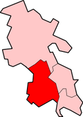
Northend, Buckinghamshire

Last updated

Northend
Buckinghamshire UK location map.svg
Red pog.svg
Northend
Location within Buckinghamshire
OS grid reference SU735925
Civil parish
District
Unitary authority
Shire county
Ceremonial county
Region
Country England
Sovereign state United Kingdom
Post town HENLEY-ON-THAMES
Postcode district RG9
Police Thames Valley
Fire Buckinghamshire
Ambulance South Central
UK Parliament
List of places
UK
England
Buckinghamshire
51°37′35″N0°56′22″W / 51.6265°N 0.9395°W / 51.6265; -0.9395 Coordinates: 51°37′35″N0°56′22″W / 51.6265°N 0.9395°W / 51.6265; -0.9395

Northend is a village that straddles the border of the two English counties of Buckinghamshire and Oxfordshire. [1] [2] [3] The eastern half is in the civil parish of Turville in Buckinghamshire, while the western half is across the border into Oxfordshire, in the Watlington parish.

Related Research Articles

<span class="mw-page-title-main">Oxfordshire</span> County of England

Oxfordshire is a landlocked county in the far west of the government statistical region of South East England. The ceremonial county borders Warwickshire to the north-west, Northamptonshire to the north-east, Buckinghamshire to the east, Berkshire to the south, Wiltshire to the south-west and Gloucestershire to the west.

Cuddington, Buckinghamshire Human settlement in England

Cuddington is a village and civil parish within the Buckinghamshire district in the ceremonial county of Buckinghamshire, England. It is near the Oxfordshire border, about six miles west of Aylesbury.

Drayton Parslow Human settlement in England

Drayton Parslow is a village and civil parish in the unitary authority area of Buckinghamshire, England, about 3.5 miles (5.6 km) south of Bletchley. In the 2001 census the parish had a population of 596, increasing at the 2011 census to 614.

Fingest Human settlement in England

Fingest is a village in Buckinghamshire, England. It is in the Chiltern Hills near the border with Oxfordshire. It is about six miles WSW of High Wycombe. It lies in the civil parish of Hambleden.

<span class="mw-page-title-main">Ickford</span> Human settlement in England

Ickford is a village and civil parish in the unitary authority area of Buckinghamshire, England. It is on the boundary with Oxfordshire, about 4 miles (6.4 km) west of the market town of Thame.

Kingsey Human settlement in England

Kingsey is a small village and civil parish in Aylesbury Vale district in Buckinghamshire, England. It is near the boundary with Oxfordshire, about two miles east of Thame and a mile south of Haddenham.

<span class="mw-page-title-main">Marsh Gibbon</span> Human settlement in England

Marsh Gibbon is a village and civil parish in Buckinghamshire, England. It is close to the A41 and the border with Oxfordshire about 4 miles (6.4 km) east of Bicester.

Westbury, Buckinghamshire Human settlement in England

Westbury is a village and civil parish in northern Buckinghamshire, England, about 2.5 miles (4.0 km) east of Brackley and 5 miles (8.0 km) west of Buckingham. It is close to the A422 and the border with Oxfordshire.

Oakley, Buckinghamshire Human settlement in England

Oakley is a village and civil parish in Buckinghamshire, England. It has an area of 2,206 acres (893 ha) and includes about 400 households. The 2011 Census recorded the population as 1,007.

Taplow Human settlement in England

Taplow is a village and civil parish in the Unitary Authority of Buckinghamshire, England. It sits on the left bank of the River Thames, facing Maidenhead in the neighbouring county of Berkshire, with Cippenham and Burnham to the east. It is the south-westernmost settlement in Buckinghamshire.

Arthur Blomfield English architect

Sir Arthur William Blomfield was an English architect. He became president of the Architectural Association in 1861; a Fellow of the Royal Institute of British Architects in 1867 and vice-president of the RIBA in 1886. He was educated at Trinity College, Cambridge, where he read Architecture.

Stonesfield Village and civil parish in England

Stonesfield is a village and civil parish about 5 miles (8 km) north of Witney in Oxfordshire, and about 10 miles (17 km) north-west of Oxford. The village is on the crest of an escarpment. The parish extends mostly north and north-east of the village, in which directions the land rises gently and then descends to the River Glyme at Glympton and Wootton about 3 miles (5 km) to the north-east. South of Stonesfield, below the escarpment, is the River Evenlode which touches the southern edge of the parish. At the centre of Stonesfield stands the 13th-century church of St James the Great as well as a Wesleyan chapel, Stonesfield Methodist Church, slightly further west. The village is known for Stonesfield slate, a form of Cotswold stone mined particularly as a roofing stone and also a rich source of fossils. The architecture in Stonesfield features many old Cotswold stone properties roofed with locally mined slate along with some late 20th-century buildings and several properties under construction. The 2011 Census recorded the parish's population as 1,527.

Bloxham Human settlement in England

Bloxham is a village and civil parish in northern Oxfordshire several miles from the Cotswolds, about 3 miles (5 km) southwest of Banbury. It is on the edge of a valley and overlooked by Hobb Hill. The village is on the A361 road. The 2011 Census recorded the parish's population as 3,374.

Greenham Village in England

Greenham is a village and civil parish in Berkshire, England. Greenham commences immediately south-east of Newbury and is in West Berkshire. It was recorded in the Domesday Book as Greneham.

<span class="mw-page-title-main">Counties (Detached Parts) Act 1844</span> United Kingdom legislation

The Counties Act 1844, which came into effect on 20 October 1844, was an Act of Parliament of the United Kingdom which eliminated many outliers or exclaves of counties in England and Wales for civil purposes. The changes were based on recommendations by a boundary commission, headed by the surveyor Thomas Drummond and summarized in a schedule attached to the Parliamentary Boundaries Act 1832. This also listed a few examples of civil parishes divided by county boundaries, most of which were dealt with by later legislation.

Wyck Rissington Human settlement in England

Wyck (Wick) Rissington is a village and civil parish in the picturesque Cotswold hills of Gloucestershire, England. The village is located 1.5 miles (2.4 km) north-east of Bourton-on-the-Water. The name 'Wyck Rissington' translates from the Saxon as "A building of special significance on a hill covered with brushwood".

Barford St Michael Human settlement in England

Barford St Michael is a village on the south bank of the River Swere in Oxfordshire, England, about 5 miles (8 km) south of Banbury.

Horton-cum-Studley Human settlement in England

Horton-cum-Studley is a village and civil parish in Oxfordshire about 6+12 miles (10.5 km) northeast of the centre of Oxford and bordering Otmoor, and is one of the "Seven Towns" of Otmoor. The 2011 Census recorded the parish's population as 455. Although traditionally a rural community, according to the latest demographic data, it is now home to professionals who work in Oxford and the surrounding urban centers of Bicester, High Wycombe and West London. There are many younger professional families in the village because of a popular village school in nearby Beckley. A majority of residents in the village work in the Healthcare and Educational Sectors.

Tiddington, Oxfordshire Human settlement in England

Tiddington is a village in the civil parish of Tiddington-with-Albury, about 3+12 miles (5.6 km) west of Thame in Oxfordshire, England. It is on the A418 road between Thame and Oxford. The 2011 Census recorded Tiddington-with-Albury's population as 683. Tiddington is on the county boundary with Buckinghamshire. It was a manor and hamlet of the parish of Albury, although for most of its history it has been a larger place than Albury. In 1866 Tiddington became a separate civil parish, but in 1932 the two parishes were reunited.

<span class="mw-page-title-main">Aylesbury Vale</span> Place in England

The Aylesbury Vale is a geographical region in Buckinghamshire, England, which is bounded by the Borough of Milton Keynes and South Northamptonshire to the north, Central Bedfordshire and the Borough of Dacorum (Hertfordshire) to the east, the Chiltern Hills to the south and South Oxfordshire to the west. It is named after Aylesbury, the county town of Buckinghamshire. Winslow and Buckingham are among the larger towns in the vale.

References

  1. "Residents in village that has run out of water furious as they can't flush toilets". The Independent. 12 August 2022. Retrieved 8 September 2022.
  2. "Oxford village first in Britain without water: residents are now relying on bottled water deliveries". thisisoxfordshire. Retrieved 8 September 2022.
  3. "'This is the future': the Oxfordshire village living without running water". the Guardian. 10 August 2022. Retrieved 8 September 2022.