Bledlow Ridge | |
---|---|
Bledlow Ridge | |
Location within Buckinghamshire | |
Population | 940 (2004) |
OS grid reference | SU798976 |
Civil parish | |
Unitary authority | |
Ceremonial county | |
Region | |
Country | England |
Sovereign state | United Kingdom |
Post town | HIGH WYCOMBE |
Postcode district | HP14 |
Dialling code | 01494 |
Police | Thames Valley |
Fire | Buckinghamshire |
Ambulance | South Central |
UK Parliament | |
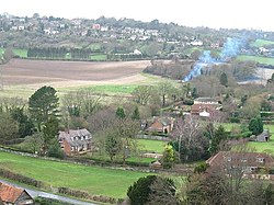
Bledlow Ridge is a village in the civil parish of Bledlow-cum-Saunderton in Buckinghamshire, England. [1] [2] In 2004 the population was 940. It is situated in the Chiltern Hills, about 4 miles south-southwest of Princes Risborough and on the road between the High Wycombe and Chinnor.
Originally the hamlet was within the ecclesiastical parish of Bledlow. It gained separate status in 1868 when the new chapel, dedicated to St Paul, was constructed.
In common with other similar villages in the Chiltern Hills properties have become increasingly sought after due to its location and the improvement in rail and road connections to London. It has a recently refurbished village shop, The Country Store Kedai, and a local school, Bledlow Ridge School. Bledlow Ridge has a number of clubs including the youth club "Bridge", Bledlow Ridge Tennis Club, and Bledlow Ridge Cricket Club. As well as the corner shop, there is also an Equestrian Centre, children's playground, tennis courts and a cricket pitch. Yoesden, south of Chinnor Road, is a nature reserve managed by the Berkshire, Buckinghamshire and Oxfordshire Wildlife Trust.
The Chiltern Hills are a chalk escarpment in southern England, northwest of London, covering 660 square miles (1,700 km2) across Oxfordshire, Buckinghamshire, Hertfordshire, and Bedfordshire, stretching 45 miles (72 km) from Goring-on-Thames in the southwest to Hitchin in the northeast. The hills are 12 miles (19 km) at their widest.
Wendover is a town and civil parish at the foot of the Chiltern Hills in Buckinghamshire, England. It is situated at the point where the main road across the Chilterns between London and Aylesbury intersects with the once important road along the foot of the Chilterns. The town is some 35 miles (56 km) north west of London and 5 miles (8 km) south east of Aylesbury.
Princes Risborough is a market town and civil parish in Buckinghamshire, England, about 9 miles (14 km) south of Aylesbury and 8 miles (13 km) north west of High Wycombe. It lies at the foot of the Chiltern Hills, at the north end of a gap or pass through the Chilterns, the south end of which is at West Wycombe. The A4010 road follows this route from West Wycombe through the town and then on to Aylesbury.
Chalfont St Giles is a village and civil parish in southeast Buckinghamshire, England. It is in a group of villages called The Chalfonts, which also includes Chalfont St Peter and Little Chalfont.
Bledlow is a village and former civil parish, now in the parish of Bledlow-cum-Saunderton, in Buckinghamshire, England. It is about 2 miles (3.2 km) west-southwest of Princes Risborough, and is on the county boundary with Oxfordshire. In 1931 the parish had a population of 925. On 1 April 1934 the parish was abolished to form "Bledlow cum Saunderton".
Bradenham is a village and civil parish in Buckinghamshire, England. It is near Saunderton, off the main A4010 road between Princes Risborough and High Wycombe.
Holmer Green is a village in the civil parish of Little Missenden, in Buckinghamshire, England. It is next to Hazlemere, about 3 miles (5 km) south of Great Missenden.
Horsenden is a hamlet and former civil parish, now in the parish of Longwick-cum-Ilmer, in Buckinghamshire, England. It is approximately one mile West of Princes Risborough, seven miles south of Aylesbury and three miles south-west of Chinnor in Oxfordshire. The Icknield Way passes just to the north of the village from north-east to south-west, although there is no connecting road through the hamlet itself. In 1931 the parish had a population of 53.
Lacey Green is a village and civil parish in the Buckinghamshire district, south-east of Princes Risborough, in the ceremonial county of Buckinghamshire, England. It is in the Chiltern Hills above the town.
Loosley Row is a hamlet in the civil parish of Lacey Green, Buckinghamshire, England. It is located in the Chiltern Hills to the east of the main town of Princes Risborough. In the 2011 Census, the population was recorded in the Lacey Green Parish, which included Speen, parts of Walter's Ash, and Lacey Green, with a combined population of 2,559.
Radnage is a village and civil parish in the Buckinghamshire district of Buckinghamshire, England. It is in the Chiltern Hills about two miles north east of Stokenchurch and six miles WNW of High Wycombe.
Saunderton is a village and former civil parish, now in the parish of Bledlow-cum-Saunderton, Buckinghamshire, England. It is in the Saunderton Valley in the Chiltern Hills. It is 2 miles (3 km) southwest of Princes Risborough, Saunderton Lee, about 2 miles (3 km) further south and a residential area on the A4010 road around Saunderton railway station, it is 5 miles (8 km) northwest of High Wycombe. 9ref>"Population statistics Saunderton AP/CP through time". A Vision of Britain through Time. Retrieved 9 August 2023.</ref>
Jordans is a village in Chalfont St Giles parish, Buckinghamshire, England, and the civil parish of Hedgerley. It is a centre for Quakerism, holds the burial place of William Penn, founder of the Province of Pennsylvania, and so is a popular place with American visitors. It also contains the Mayflower Barn, made from ship timbers sometimes claimed to be from the Mayflower. Some 245 households and 700 residents are served by a nursery, primary school, youth hostel, village hall and community shop. Forty of the houses and cottages and 21 flats are owned by a non-profit society that manages the village and its amenities.
Shenley Church End is a village, district and wider civil parish in Milton Keynes, Buckinghamshire, England, about 2 miles (3.2 km) south-west of Central Milton Keynes, and the same distance north-west of Bletchley. Together with its neighbouring districts of Shenley Brook End, Shenley Wood and Shenley Lodge, the districts are collectively known as "The Shenleys".
Lilley is a small village and civil parish situated between Hitchin and Luton in Hertfordshire, England. Lilley stands on high ground: nearby Telegraph Hill is just over 600 feet above sea level.
Shadwell is a village and civil parish in north-east Leeds, West Yorkshire, England. The village is 6 miles (9.7 km) to the north east of Leeds city centre.
The hamlet of Beacon Hill, is situated off the B474 near Penn and on the outskirts of High Wycombe Buckinghamshire. Nearby is the Golf Course at Wycombe Heights.
Bennett End is a hamlet near Radnage and Bledlow Ridge in Buckinghamshire, England. At the 2011 Census the population of the hamlet was included in the civil parish of Lane End.
Lodge Hill is a 31.8-hectare (79-acre) Site of Special Scientific Interest north of Bledlow Ridge in Buckinghamshire. The local planning authorities are Wycombe District Council and Buckinghamshire County Council. The site is in the Chilterns Area of Outstanding Natural Beauty, and The Ridgeway long-distance footpath crosses it.
Yoesden, often known as Yoesden Bank, is a 13-hectare (32-acre) nature reserve in Bledlow Ridge in Buckinghamshire. It is managed by the Berkshire, Buckinghamshire and Oxfordshire Wildlife Trust. It is in the Chilterns Area of Outstanding Natural Beauty.
Media related to Bledlow Ridge at Wikimedia Commons