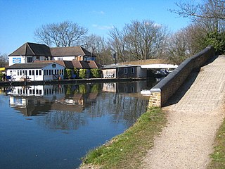
Cowley is a village contiguous with the town of Uxbridge in the London Borough of Hillingdon. A largely suburban village with 16 listed buildings, Cowley is 15.4 miles (24.8 km) west of Charing Cross, bordered to the west by Uxbridge Moor in the Green Belt and the River Colne, forming the border with Buckinghamshire. Cowley was an ancient parish in the historic county of Middlesex.

Stepney is a district in the East End of London in the London Borough of Tower Hamlets. The district is no longer officially defined, and is usually used to refer to a relatively small area. However, for much of its history the place name applied to a much larger manor and parish. Stepney Green is a remnant of a larger area of Common Land formerly known as Mile End Green.

Fordingbridge is a town and broader civil parish with a population of 6,000 on the River Avon in the New Forest District of Hampshire, England, near the Dorset and Wiltshire borders and on the edge of the New Forest, with a museum and a late medieval seven-arch bridge.

Hughenden Valley is an extensive village and civil parish in Buckinghamshire, England, just to the north of High Wycombe. It is almost 8,000 acres (32 km2) in size, divided mainly between arable and wooded land. It is situated 3 miles north of central Wycombe, 12.5 miles south of the county town of Aylesbury and some 35 miles west-northwest of London.
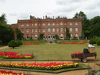
Hughenden Manor, Hughenden, Buckinghamshire is a Victorian mansion, with earlier origins, that served as the country house of the Prime Minister, Benjamin Disraeli, 1st Earl of Beaconsfield. It is now owned by the National Trust and open to the public. It sits on the brow of the hill to the west of the main A4128 road that links Hughenden to High Wycombe.

Eythrope is a hamlet and country house in the parish of Waddesdon, in Buckinghamshire, England. It is located to the south east of the main village of Waddesdon. It was bought in the 1870s by a branch of the Rothschild family, and belongs to them to this day.

Horton is a hamlet in the parish of Ivinghoe, in Buckinghamshire, England. It is in the civil parish of Slapton.

Ledburn is a hamlet in the parish of Mentmore, in Buckinghamshire, England. The name Ledburn is Anglo Saxon in origin, and means "stream with a conduit". In manorial records of 1212 it was recorded as "Leteburn".

Tattenhoe and Tattenhoe Park are adjacent districts of Milton Keynes, England, in the ancient parish of Tattenhoe. It is located at the south-western edge of the city, not far from the ruins of Snelshall Priory. It contains Howe Park Wood, a Site of Special Scientific Interest and one of England's few remaining primeval woodlands and home to a wide variety of wildlife, notably Odonata.
Widmer End is a hamlet in the parish of Hughenden, in Buckinghamshire, England.

Ardeley is a small village and civil parish in East Hertfordshire, England. The parish includes the hamlet of Cromer, as well as Wood End and Moor Green.

Aston is a village and civil parish in the East Hertfordshire district of Hertfordshire, England. According to the 2001 census it had a population of 844, increasing to 871 at the 2011 Census. Located on a ridge between Stevenage and the Beane Valley, Aston is a 10 minutes drive from the A1(M).

Elthorne was a hundred of the historic county of Middlesex, England. It was a north-west portion having these parishes:

Kirby Sigston is a village and civil parish in the Hambleton district of North Yorkshire, England, approximately 4 miles (6.4 km) east of Northallerton. The village is situated on Cod Beck, and the wider parish contains the hamlet of Jeater Houses due east of the village on the trunk A19 road. The village is mentioned in the Domesday Book of 1086 as having 75 ploughlands, and its name derives from a combination of the Old Norse Kirkju-býr and Sigges tūn. Sigston is also the name of a village nearby.

Cryers Hill is a hamlet in the parish of Hughenden and in Buckinghamshire, England. It was formerly known as Ravensmere.
Spurlands End is a hamlet in the parish of Little Missenden, in Buckinghamshire, England.

Isleworth Hundred was a subdivision of the historic county of Middlesex, England. In Domesday Book (1086) it was recorded as Hundeslaw Hundred.

Eastminster was a Cistercian abbey on Tower Hill at East Smithfield in London, founded by Edward III in 1350 immediately outside the Roman London Wall in what is now the London Borough of Tower Hamlets. It stood just to the north of an older royal foundation, the Hospital and Collegiate Church of St Katharine by the Tower.

The following is a list of reportedly haunted locations in the United Kingdom.

Marks was a manor house located near Marks Gate at the northern tip of the London Borough of Barking and Dagenham in London, England, the house standing on what is now Warren Hall Farm, about two miles west of Romford. The name Marks is believed to have been derived from the de Merk family who built the original manor in the 14th Century. The manor house was demolished in 1808.

