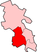
Hedsor

Last updated

Hedsor
St Nicholas's, Hedsor - geograph.org.uk - 103124.jpg
St Nicholas' parish church
Buckinghamshire UK location map.svg
Red pog.svg
Hedsor
Location within Buckinghamshire
Population95  [1]
OS grid reference SU9187
Civil parish
  • Hedsor
Unitary authority
Ceremonial county
Region
Country England
Sovereign state United Kingdom
Post town High Wycombe
Postcode district HP10
Post town Maidenhead
Postcode district SL6
Post town Bourne End
Postcode district SL8
Dialling code 01628
Police Thames Valley
Fire Buckinghamshire
Ambulance South Central
UK Parliament
List of places
UK
England
Buckinghamshire
51°34′12″N0°40′52″W / 51.570°N 0.681°W / 51.570; -0.681

Hedsor is a small village and civil parish in Wycombe district in Buckinghamshire, England, in the very south of the county, near the River Thames and Bourne End. It is in the civil parish of Wooburn. [2]

The village toponym is derived from the Old English for "Hædde's cliff", referring to the position of the village on a cliff overlooking the Thames.

Hedsor House was the ancient seat of the de Hedsor family, who took their name from the village. They owned it at the time of the Domesday Book in 1086. The modern manor house was built in 1778, and stands on a hill in the village with a commanding view of the Thames and of Berkshire.

In 1583 Rowland Hynd built a new Tudor manor house at Hedsor which was badly damaged by fire in 1795 and eventually demolished in 1865. At about this time the fourth Lord Boston commissioned the architect James Knowles[ clarification needed ] to design a new house at Hedsor.

Hedsor House remained as the Boston family's country house until early in the 20th century, during which time Queen Victoria was said to be a frequent visitor to the house and its beautiful surrounding parkland.

Rowland Hynd had the Church of England parish church of Saint Nicholas "re-edified" in 1608.

Related Research Articles

<span class="mw-page-title-main">West Wycombe</span> Human settlement in England

West Wycombe is a small village famed for its manor houses and its hills. It is three miles west of High Wycombe, Buckinghamshire, England.

<span class="mw-page-title-main">Bourne End, Buckinghamshire</span> Village in Buckinghamshire England

Bourne End is a village mostly in the parish of Wooburn, but partly in that of Little Marlow in Buckinghamshire, England. It is about five miles (8 km) south-east of High Wycombe and three miles (5 km) east of Marlow, near the boundary with Berkshire and close to where the Buckinghamshire River Wye empties into the Thames.

<span class="mw-page-title-main">Drayton Beauchamp</span> Human settlement in England

Drayton Beauchamp is a village and civil parish within Aylesbury Vale district in Buckinghamshire, England. It is in the east of the county bordering Hertfordshire, about six miles from Aylesbury and two miles from Tring.

<span class="mw-page-title-main">Ickford</span> Human settlement in England

Ickford is a village and civil parish in the unitary authority area of Buckinghamshire, England. It is on the boundary with Oxfordshire, about 4 miles (6.4 km) west of the market town of Thame.

<span class="mw-page-title-main">Medmenham</span> Human settlement in England

Medmenham is a village and civil parish in south-west Buckinghamshire, England. It is on the River Thames, about 3+12 miles (5.6 km) southwest of Marlow and 3 miles (4.8 km) east of Henley-on-Thames. The parish also includes Danesfield, a housing estate predominantly for RAF officers, although families of other ranks from the RAF, Royal Navy and British Army also live there.

<span class="mw-page-title-main">Wooburn</span> Human settlement in England

Wooburn is a large village in Buckinghamshire, England. It is located off the A4094 road between Wooburn Green and Bourne End in the very south of the county near the River Thames, about two miles south west of Beaconsfield and four miles east of Marlow. Wooburn is one of the two principal settlements within Wooburn, a civil parish in Wycombe district.

<span class="mw-page-title-main">Radley</span> Human settlement in England

Radley is a village and civil parish about 2 miles (3 km) northeast of the centre of Abingdon, Oxfordshire. The parish includes the hamlet of Lower Radley on the River Thames. It was part of Berkshire until the 1974 boundary changes transferred it to Oxfordshire. The village is home to Radley College, a famous boarding independent school for boys from the age of thirteen to eighteen that consists of 690 pupils.

<span class="mw-page-title-main">Bromham, Wiltshire</span> Human settlement in England

Bromham is a village and civil parish in Wiltshire, England. The village is 3+12 miles (6 km) northwest of Devizes and the same distance east of Melksham.

<span class="mw-page-title-main">Culham</span> Human settlement in England

Culham is a village and civil parish in a bend of the River Thames, 1 mile (1.6 km) south of Abingdon in Oxfordshire. The parish includes Culham Science Centre and Europa School UK. The parish is bounded by the Thames to the north, west and south, and by present and former field boundaries to the east. It is low-lying and fairly flat, rising from the Thames floodplain in the south to a north-facing escarpment in the north up to 260 feet (80 m) above sea level. The 2011 Census recorded its population as 453.

<span class="mw-page-title-main">Beaconsfield (UK Parliament constituency)</span> Parliamentary constituency in the United Kingdom since 1974

Beaconsfield is a constituency in Buckinghamshire represented in the House of Commons of the UK Parliament since 2019 by Joy Morrissey of the Conservative Party. She succeeded Independent and former Conservative Dominic Grieve, whom she defeated following his suspension from the party. The constituency was established for the February 1974 general election.

<span class="mw-page-title-main">Cookham</span> Village in Berkshire, England

Cookham is a historic Thames-side village and civil parish on the north-eastern edge of Berkshire, England, 2.9 miles (5 km) north-north-east of Maidenhead and opposite the village of Bourne End. Cookham forms the southernmost and most rural part of the High Wycombe urban area. With adjoining Cookham Rise and Cookham Dean, it had a combined population of 5,779 at the 2011 Census. In 2011, The Daily Telegraph deemed Cookham Britain's second richest village.

<span class="mw-page-title-main">Wargrave</span> Town in Berkshire, England

Wargrave is a historic village and civil parish in Berkshire, England. The village is primarily on the River Thames but also along the confluence of the River Loddon and lies on the border with southern Oxfordshire. The village has many old listed buildings, two marinas with chandlery services for boats, a boating club and rises steeply to the northeast in the direction of Bowsey Hill, with higher parts of the village generally known as Upper Wargrave. In Upper Wargrave is a Recreation Ground with a cricket club, bowls club, football pitch and tennis club.

<span class="mw-page-title-main">Norley</span> Human settlement in England

Norley is a village and civil parish in Cheshire, England, north of Delamere Forest, near the village of Cuddington. The population at the 2011 census was 1,169. Its name is derived from “Norlegh”, which means “north clearing”.

<span class="mw-page-title-main">Buckland, Oxfordshire</span> Human settlement in England

Buckland is a village and large civil parish about 4 miles (6.4 km) northeast of Faringdon in the Vale of White Horse District. Buckland was part of Berkshire until the 1974 boundary changes transferred it to Oxfordshire. The 2011 Census recorded the parish's population as 588. Outside the village the civil parish includes the small settlements of Carswell and Barcote to the west, Buckland Marsh to the north, and the modern development of Gainfield on the southern boundary.

<span class="mw-page-title-main">Rotherfield Greys</span> Village in Oxfordshire, England

Rotherfield Greys is a village and civil parish in the Chiltern Hills in South Oxfordshire. It is 2 miles (3 km) west of Henley-on-Thames and just over 1 mile (1.6 km) east of Rotherfield Peppard. It is linked by a near-straight minor road to Henley.

<span class="mw-page-title-main">Cople</span> Human settlement in England

Cople is a village and civil parish in the English county of Bedfordshire. The name Cople is derived from the phrase Cock Pool, a place where chickens were kept, that was mentioned in the Domesday Book.

<span class="mw-page-title-main">Clifford, West Yorkshire</span> Village in West Yorkshire, England

Clifford is a small village in West Yorkshire, England. The population at the 2011 Census was 1,662. The village is 3 miles (4.8 km) south of Wetherby. Many of the older buildings are built of magnesian limestone.

<span class="mw-page-title-main">Fyfield, Oxfordshire</span> Human settlement in England

Fyfield is a village and former civil parish, now in the parish of Fyfield and Tubney, in the Vale of White Horse district, in the county of Oxfordshire, England. It is about 4+12 miles (7 km) west of Abingdon-on-Thames. It was part of Berkshire until the 1974 boundary changes transferred it to Oxfordshire. The village used to be on the main A420 road between Oxford and Faringdon, but a bypass now carries the main road just south of the village. In 1951 the parish had a population of 280. On 1 April 1952 the parish was abolished and merged with Tubney to form "Fyfield and Tubney".

<span class="mw-page-title-main">Hinton Waldrist</span> Human settlement in England

Hinton Waldrist is a village and civil parish in the Vale of White Horse, England. It was part of Berkshire until the 1974 boundary changes transferred it to Oxfordshire. The village is between Oxford and Faringdon, 9 miles (14 km) southwest of Oxford. The parish includes the hamlet of Duxford. The 2011 Census recorded the parish's population as 328.

<span class="mw-page-title-main">Forest Hill, Oxfordshire</span> Human settlement in England

Forest Hill is a village in Forest Hill with Shotover civil parish in Oxfordshire, about 4.5 miles (7 km) east of Oxford. The village which is about 330 feet (100 m) above sea level is on the northeastern brow of a ridge of hills. The highest point of the ridge is Red Hill, which rises to 440 feet (130 m) just south of the village. The 2011 Census recorded Forest Hill with Shotover's population as 856.

References

  1. Wycombe DC Parish Fact file 2001 Census Archived 2006-09-27 at the Wayback Machine
  2. 'Parishes: Hedsor', in W. Page (ed.), A History of the County of Buckingham, Vol. 3 (V.C.H., London 1925), pp. 54-57 (British History Online accessed 28 September 2023).