Horsenden

Last updated

Horsenden
Horsenden village houses - geograph.org.uk - 32879.jpg
Horsenden village houses, 2005
Buckinghamshire UK location map.svg
Red pog.svg
Horsenden
Location within Buckinghamshire
Civil parish
Unitary authority
Ceremonial county
Region
Country England
Sovereign state United Kingdom
List of places
UK
England
Buckinghamshire
51°43′10.24″N0°51′11.63″W / 51.7195111°N 0.8532306°W / 51.7195111; -0.8532306

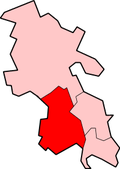
Horsenden is a hamlet and former civil parish, now in the parish of Longwick-cum-Ilmer, in Buckinghamshire, England. It is approximately one mile West of Princes Risborough, seven miles south of Aylesbury and three miles south-west of Chinnor in Oxfordshire. The Icknield Way passes just to the north of the village from north-east to south-west, although there is no connecting road through the hamlet itself. In 1931 the parish had a population of 53. [1]

Contents

Name

The name Horsenden is from the Anglo Saxon Horsan-dun and means 'Horsa's hill or valley'. Horsa was one of the first Anglo Saxon settlers of Britain, who settled in Kent in the Fifth century. The association of the area to Horsa is unknown.

History

After the Norman Conquest the land was in the possession of the Count of Mortain. After 1215 it was passed to Robert de Braybrook. Sir John Donne then acquired the estates in 1480. Horsenden House as it was then known was garrisoned during the English Civil War for Charles I by the Royalist Sir John Denham who managed to maintain possession after the Restoration.

During the 18th and 19th century there were a number of owners and the House slipped into neglect. In 1810, the House was restored and rebuilt and sometime later renamed Horsenden Manor.

At the height of The Blitz during the Second World War, the insurance company Norwich Union moved their offices from Piccadilly, Fleet Street and St James' into the Manor but after the war they moved back to their London offices. [2]

Jamiroquai vocalist Jay Kay has owned Horsenden Manor since 1995 and has a recording studio, granary and garages for his top-end car collection.

The parish church is dedicated to St Michael and All Angels. The church has sat on the same site since 1210, however part of the building is 15th century at its eldest. In 1765, the nave and west tower were demolished and the current tower was built, it still contains its original bell dated 1582 and in the late 19th century the chancel was extended 8 feet to the east.

The hamlet has its own tennis club, and on the same site can be found Princes Risborough's football and cricket teams.

On 1 April 1934 the parish was abolished to form "Longwick cum Ilmer" and Bledlow cum Saunderton, part also went to Princes Risborough. [3]

Related Research Articles

<span class="mw-page-title-main">Owlswick</span>

Owlswick is a hamlet in Buckinghamshire, England, about 3 miles E of Thame and 4 miles SSE of Aylesbury. It is part of the civil parish of Longwick-cum-Ilmer and is in the ecclesiastical parish of Monks Risborough.

Monks Risborough is a village and ecclesiastical parish in Buckinghamshire, England, lying between Princes Risborough and Great Kimble. The village lies at the foot of the northern scarp of the Chiltern Hills. It is 8 miles (13 km) south of the county town of Aylesbury and 9.5 miles (15.3 km) north of High Wycombe, on the A4010 road.

<span class="mw-page-title-main">Princes Risborough</span> Market town in Buckinghamshire, England

Princes Risborough is a market town and civil parish in Buckinghamshire, England, about 9 miles (14 km) south of Aylesbury and 8 miles (13 km) north west of High Wycombe. It lies at the foot of the Chiltern Hills, at the north end of a gap or pass through the Chilterns, the south end of which is at West Wycombe. The A4010 road follows this route from West Wycombe through the town and then on to Aylesbury.

<span class="mw-page-title-main">Bledlow</span> Human settlement in England

Bledlow is a village and former civil parish, now in the parish of Bledlow-cum-Saunderton, in Buckinghamshire, England. It is about 1+12 miles (2.4 km) WSW of Princes Risborough, and is on the county boundary with Oxfordshire. In 1931 the parish had a population of 925. On 1 April 1934 the parish was abolished to form "Bledlow cum Saunderton".

<span class="mw-page-title-main">Ilmer</span> Human settlement in England

Ilmer is a village and former civil parish, now in the parish of Longwick-cum-Ilmer, in Buckinghamshire, England. It is at the foot of the Chiltern Hills about 3 miles (5 km) northwest of Princes Risborough, near the boundary with Oxfordshire. In 1931 the parish had a population of 40. On 1 April 1934 the parish was abolished to form "Longwick cum Ilmer".

<span class="mw-page-title-main">Longwick</span> Human settlement in England

Longwick is a village 1+14 miles (2 km) northwest of Princes Risborough, Buckinghamshire, England, on the A4129 road.

<span class="mw-page-title-main">Meadle</span>

Meadle is a hamlet in the civil parish of Longwick-cum-Ilmer, in Buckinghamshire, England. It is located to the north of the village of Monks Risborough and near Little Kimble. The current population of Meadle is about 75. Most of the buildings are very old: farmhouses and labourers' cottages built in traditional red clay brick with thatched roofs. A small stream rises in the village and ultimately joins the Thames.

<span class="mw-page-title-main">Radclive</span> Human settlement in England

Radclive is a village on the River Great Ouse just over 1 mile (1.6 km) west of Buckingham in Buckinghamshire, England. It is in the civil parish of Radclive-cum-Chackmore in Aylesbury Vale district. The parish includes the hamlet of Chackmore about 1.5 miles (2.4 km) north of Buckingham.

<span class="mw-page-title-main">Saunderton</span> Human settlement in England

Saunderton is a village and former civil parish, now in the parish of Bledlow-cum-Saunderton, Buckinghamshire, England. It is in the Saunderton Valley in the Chiltern Hills, the village consists of three main areas: a linear settlement along Bledlow Road about 1+14 miles (2 km) southwest of Princes Risborough, Saunderton Lee, about 1+12 miles (2 km) further south and a residential area on the A4010 road around Saunderton railway station, about 4+12 miles (7 km) northwest of High Wycombe. This residential area, unlike the other two parts of the village, is in the HP14 postcode district, meaning its post town is High Wycombe, not Princes Risborough, the boundary between the two post towns passing just south of Grange Farm. In 1931 the parish had a population of 454.

<span class="mw-page-title-main">Fritton, Great Yarmouth</span> Human settlement in England

Fritton is a village and former civil parish in county of Norfolk, England. The village is located 6 miles (9.7 km) south-west of Great Yarmouth and 16 miles (26 km) south-east of Norwich, along the A143 between Gorleston-on-Sea and Haverhill. In 1961 the parish had a population of 192.

<span class="mw-page-title-main">Burnham Deepdale</span> Human settlement in England

Burnham Deepdale is a village and former civil parish, now in the parish of Brancaster, in the King's Lynn and West Norfolk district, on the north coast of the county of Norfolk, England. Burnham Deepdale, Brancaster and Brancaster Staithe form a more or less continuous settlement along the A149, at the edge of the Brancaster Manor marshland and the Scolt Head Island National Nature Reserve. In 1931 the parish had a population of 81.

<span class="mw-page-title-main">Mucking</span> Hamlet in Essex, England

Mucking is a hamlet and former Church of England parish and civil parish adjoining the Thames Estuary in the Thurrock unitary authority area, in southern Essex, England. It is located approximately 2 miles (3.2 km) south of the town of Stanford-le-Hope. In 1931 the civil parish had a population of 498.

<span class="mw-page-title-main">Botolphs</span> Human settlement in England

Botolphs, formerly known as Annington, is a tiny village and former civil parish, now in the parish of Bramber, in the Horsham District of West Sussex, England. It is in the Adur Valley 1.5 miles (2.4 km) southeast of Steyning on the road between Steyning and Coombes. Botolphs lies on the South Downs Way long-distance footpath. In 1931 the parish had a population of 64. On 1 April 1933 the parish was abolished and merged with Bramber.

<span class="mw-page-title-main">Wendy, Cambridgeshire</span> Human settlement in England

Wendy is a hamlet and former civil parish, now in the parish of Shingay cum Wendy, in the South Cambridgeshire district, in the county of Cambridgeshire, England around 5 miles north west of Royston. In 1951 the parish had a population of 81.

<span class="mw-page-title-main">Wharram-le-Street</span> Village and civil parish in North Yorkshire, England

Wharram-le-Street is a village and former civil parish, now in the parish of Wharram, in North Yorkshire, England.

<span class="mw-page-title-main">Cockthorpe</span> Human settlement in England

Cockthorpe is a village and former civil parish, now in the parish of Binham, in the North Norfolk district, in the county of Norfolk, England. It is 5.2 miles (8.4 km) north-west of Holt, 28.9 miles (46.5 km) north-west of Norwich and 127 miles (204 km) north of London. In 1931 the parish had a population of 55. On 1 April 1935 the parish was abolished and merged with Binham.

<span class="mw-page-title-main">Ashby, Suffolk</span> Human settlement in England

Ashby is a former civil parish, now in the parish of Somerleyton, Ashby and Herringfleet, in the East Suffolk district, in the north of the English county of Suffolk. It is 5+12 miles (8.9 km) north-west of Lowestoft.

<span class="mw-page-title-main">Ousden</span> Human settlement in England

Ousden is a village and civil parish in the West Suffolk district of Suffolk in eastern England. It is located around six miles west of Bury St Edmunds and 72 miles north of London, and as of 2011, its population is 266. The village has an Anglican church of St Peter's and a chapel in the cemetery dedicated to St Barnabas.

<span class="mw-page-title-main">Shingay</span> Human settlement in England

Shingay is a hamlet and former civil parish, now in the parish of Shingay cum Wendy, in the South Cambridgeshire district, in the county of Cambridgeshire, England around 5 miles north west of Royston. In 1951 the parish had a population of 38.

<span class="mw-page-title-main">Honeychurch, Devon</span> Village in Devon, England

Honeychurch is a village and former civil parish now in the parish of Sampford Courtenay, in the West Devon district of the English county of Devon. It was originally an ancient parish in the Black Torrington hundred of northwest Devon.

References

  1. "Population statistics Horsenden AP/CP through time". A Vision of Britain through Time . Retrieved 9 August 2023.
  2. Payne, Mike and Angela (2009). "The Voices of Princes Risborough", In Times of War pg.17
  3. "Relationships and changes Horsenden AP/CP through time". A Vision of Britain through Time. Retrieved 9 August 2023.