Walters Ash

Last updated

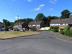
Ash Close, Walter's Ash, 2010 Ash Close, Walter's Ash - geograph.org.uk - 2230159.jpg
Ash Close, Walter's Ash, 2010

Walters Ash (also sometimes called Walter's Ash) is a village in the parish of Bradenham, in Buckinghamshire, England. It is located in the Chiltern Hills, to the west of the main village, adjacent to Naphill. Between 1983 and 1985 there was a peace camp outside RAF High Wycombe station. [1] This was to protest about the RAF bunker on National Trust land designated a place of Historic Interest or Natural Beauty. There is also a water reservoir which was constructed at the same time. In February 2014 a sink hole opened under the drive of a bungalow and a car disappeared down it. [2] The village is 32 miles (51 km) west of London and 3.92 miles (6.31 km) north west of High Wycombe.
Related Research Articles

<span class="mw-page-title-main">Ash Fork, Arizona</span> CDP in Yavapai County, Arizona

Ash Fork is a census-designated place in Yavapai County, Arizona, United States. Its population was 396 at the 2010 U.S. Census, down from 457 in 2000.

<span class="mw-page-title-main">Berlin Charter Township, Michigan</span> Charter township in Michigan, United States

Berlin Charter Township is a charter township of Monroe County in the U.S. state of Michigan. At the 2010 census, the township population was 9,299.

<span class="mw-page-title-main">Sutton Bridge</span> Village and civil parish in the South Holland district of Lincolnshire, England

Sutton Bridge is a village and civil parish in the South Holland district of Lincolnshire, England. It is situated on the A17 road, 7 miles (11 km) north from Wisbech and 9 miles (14 km) west from King's Lynn. The village includes a commercial dock on the west bank of the River Nene over which spans a swing bridge, and the parish, two 19th-century lighthouses 3 miles (5 km) to the north from the village on the river Nene.

<span class="mw-page-title-main">Hellfire Caves</span> Network of man-made caverns in England

The Hellfire Caves are a network of man-made chalk and flint caverns which extend 260m underground. They are situated above the village of West Wycombe, at the southern edge of the Chiltern Hills near High Wycombe in Buckinghamshire, Southeast England.

<span class="mw-page-title-main">Hughenden Valley</span> Human settlement in England

Hughenden Valley is an extensive village and civil parish in Buckinghamshire, England, just to the north of High Wycombe. It is almost 8,000 acres (32 km2) in size, divided mainly between arable and wooded land. It is situated 3 miles north of central Wycombe, 12.5 miles south of the county town of Aylesbury and some 35 miles west-northwest of London.

<span class="mw-page-title-main">Horsenden</span>

Horsenden is a hamlet in Wycombe district, Buckinghamshire, England and is in the civil parish of Longwick-cum-Ilmer. It is approximately one mile West of Princes Risborough, seven miles south of Aylesbury and three miles south-west of Chinnor in Oxfordshire. The Icknield Way passes just to the north of the village from north-east to south-west, although there is no connecting road through the hamlet itself.

<span class="mw-page-title-main">Medmenham</span> Human settlement in England

Medmenham is a village and civil parish in south-west Buckinghamshire, England. It is on the River Thames, about 3+12 miles (5.6 km) southwest of Marlow and 3 miles (4.8 km) east of Henley-on-Thames. The parish also includes Danesfield, a housing estate predominantly for RAF officers, although families of other ranks from the RAF, Royal Navy and British Army also live there.

<span class="mw-page-title-main">Naphill</span> Human settlement in England

Naphill is a village in the parish of Hughenden Valley, in Buckinghamshire, England. It is north-west of Hughenden, on the ridge of one of the Chiltern Hills, and is adjacent to the village of Walter's Ash.

<span class="mw-page-title-main">RAF High Wycombe</span> Royal Air Force headquarters and administrative station in Buckinghamshire, England

RAF High Wycombe is a Royal Air Force station, situated in the village of Walters Ash, near High Wycombe in Buckinghamshire, England. It houses Headquarters Air Command, and was originally designed to house RAF Bomber Command in the late 1930s. The station is also the headquarters of the European Air Group and the United Kingdom Space Command.

<span class="mw-page-title-main">Bourne End railway station</span> Railway station serving the village of Bourne End, Buckinghamshire, England

Bourne End railway station serves Bourne End in Buckinghamshire, England. It is on the Marlow Branch Line between Maidenhead and Marlow, 4 miles 36 chains (7.2 km) down the line from Maidenhead and 28 miles 55 chains (46.2 km) measured from London Paddington.

<span class="mw-page-title-main">A423 road</span> Road in England

The A423 road is a primary A road in England in two sections. The main section leads from central Banbury to the A45 near Coventry.

Hethel is a small village in Norfolk, England, approximately five miles (8.0 km) south east of the market town of Wymondham, and approximately ten miles (16 km) south of the city of Norwich.

<span class="mw-page-title-main">Barry Township, Pike County, Illinois</span> Township in Illinois, United States

Barry Township is located in Pike County, Illinois. As of the 2010 census, its population was 1,675 and it contained 791 housing units.

Micklefield is a ward of High Wycombe, Buckinghamshire, located on the eastern side of the town. Surrounded on one side by the Chiltern Hills and King's Wood, it neighbours the villages of Penn and Tylers Green, as well as being adjacent to Wycombe Marsh. Some points in the Micklefield area rise to an altitude of some 450 feet, and there are some great views over the Wycombe valley.

<span class="mw-page-title-main">A433 road</span> Road in Gloucestershire

The A433 road is an A road and primary route in Gloucestershire, England.

<span class="mw-page-title-main">A4010 road</span> Road in Buckinghamshire, England

The A4010 is an important primary north–south road in Buckinghamshire, Southern England. It runs from High Wycombe at Junction 4 of the M40 motorway to Stoke Mandeville, near Aylesbury on the A413.

West Wycombe railway station was a railway station that served the village of West Wycombe, Buckinghamshire Situated about 12 mile (0.80 km) east of the village the station opened in 1862 and closed in 1958. Minutes of the Wycombe Railway state that construction of West Wycombe station in 1862 cost £430 8s 8d, equivalent to £42,731 in 2021, with additional general works at £417 8s 8d, equivalent to £41,441 in 2021.

<span class="mw-page-title-main">Bledlow railway station</span> Former railway station in Buckinghamshire, England

Bledlow railway station was an intermediate station on the Wycombe Railway which served the Buckinghamshire village of Bledlow from 1862 to 1963. It was one of two stations to serve the village, the other being Bledlow Bridge Halt on the Watlington and Princes Risborough Railway, which was 0.75 miles (1.21 km) to the south and closer to the village. The possibility of reopening the line through Bledlow, which is now part of a long-distance footpath, has been explored by Chiltern Railways, the franchise holder for the Chiltern Main Line which runs through Princes Risborough.

East Hill is a hamlet in the civil parish of West Kingsdown, in the Sevenoaks District, in the county of Kent in England.

The metropolitan area of London, England, United Kingdom, is served by six international airports and several smaller airports. Together, they make the busiest airport system in the world by passenger numbers and the second-busiest by aircraft movements. In 2018, the six airports handled a total of 177,054,819 passengers. The London airports handle over 60% of all the UK's air traffic. The airports serve a total of 14 domestic destinations and 396 international destinations.

References

  1. Peace Camps
  2. "Family: Daughter 'lucky' after car is swallowed by sinkhole - as a second hole is found". Bucks Free Press. Retrieved 27 April 2022.

Coordinates: 51°40′30″N0°47′28″W / 51.675°N 0.791°W / 51.675; -0.791