Wooburn

Last updated

Wooburn
St Paul's Church Wooburn.JPG
St. Paul's parish church
Buckinghamshire UK location map.svg
Red pog.svg
Wooburn
Location within Buckinghamshire
Population10,792 (2011 Census including Hedsor) [1]
OS grid reference SU908877
Civil parish
Unitary authority
Ceremonial county
Region
Country England
Sovereign state United Kingdom
Post town High Wycombe
Postcode district HP10
Dialling code 01628
Police Thames Valley
Fire Buckinghamshire
Ambulance South Central
UK Parliament
List of places
UK
England
Buckinghamshire
51°34′52″N0°41′28″W / 51.581°N 0.691°W / 51.581; -0.691 Coordinates: 51°34′52″N0°41′28″W / 51.581°N 0.691°W / 51.581; -0.691

Wooburn is a village in Buckinghamshire, England. [2] It is located off the A4094 road between Wooburn Green and Bourne End in the very south of the county near the River Thames, about two miles south west of Beaconsfield and four miles east of Marlow. Wooburn is one of the two principal settlements within Wooburn, a civil parish in Wycombe district. [3]

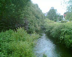
The village toponym is derived from the Old English for "walled stream". This refers to the River Wye, which has its source near West Wycombe and runs through the village to join the River Thames at Bourne End. The river runs along the boundary of Warren Nature Reserve, a Local Nature Reserve which adjoins Wooburn Park. In the Domesday Book of 1086 the village was recorded as Waborne though earlier, in 1075, it had been referred to as Waburna. [4] [5] The Church of England parish church of Saint Paul is medieval but was extensively altered by the Gothic Revival architect William Butterfield in 1869. It has a flint nave and a tall tower. There are some half timbered houses facing the churchyard and nearby there is a flint school house.

The manor house of Wooburn was once a palace of the Bishops of Lincoln.

The former Wooburn Grange Country Club was used as the exterior of the Fawlty Towers hotel in the classic 1970s sitcom. The building was destroyed by a fire in 1991, then demolished and a housing estate was built on the site.

The River Wye at Wooburn River Wye Wooburn.jpg
The River Wye at Wooburn

Related Research Articles

Bourne End, Buckinghamshire Village in Buckinghamshire, England

Bourne End is a village mostly in the Buckinghamshire, England, parish of Wooburn, but partly in that of Little Marlow. It is about five miles (8 km) south-east of High Wycombe and three miles (5 km) east of Marlow, near the border with Berkshire and close to where the Buckinghamshire River Wye empties into the Thames.

Hambleden Village in England

Hambleden is a small village and civil parish within Wycombe district in the south of Buckinghamshire, England. It is about 4 miles (6.4 km) west of Marlow, and about 3 miles (4.8 km) north east of Henley-on-Thames in Oxfordshire.

Hedsor Human settlement in England

Hedsor is a small village and civil parish in Wycombe district in Buckinghamshire, England, in the very south of the county, near the River Thames and Bourne End. It is in the civil parish of Wooburn.

Horton, Berkshire Human settlement in England

Horton is a village and civil parish in Berkshire, England. It is between Windsor and Staines-upon-Thames.

Frisby on the Wreake Human settlement in England

Frisby on the Wreake is a village and civil parish on the River Wreake about 3.5 miles (5.6 km) west of Melton Mowbray, Leicestershire, England. The 2011 Census recorded the parish's population as 557.

Everton, Bedfordshire Human settlement in England

Everton is a small rural village of about 200 dwellings and civil parish in the Central Bedfordshire district of Bedfordshire, England about 9 miles (14 km) east of the county town of Bedford.

River Wye, Buckinghamshire River in Buckinghamshire, England

The River Wye is a river in Buckinghamshire, England. Around 9 miles (14 km) in length, it rises close to West Wycombe village in the Chiltern Hills and flows through High Wycombe before emptying into the River Thames at Bourne End, on the reach above Cookham Lock. In particularly wet years, the source can temporarily change and effectively extend the river by another mile, due to a chalk spring rising above the ground in a field further up the same valley.

Beaconsfield (UK Parliament constituency)

Beaconsfield is a constituency represented in the House of Commons of the UK Parliament since 2019 by Joy Morrissey of the Conservative Party.

Cookham Village in Berkshire, England

Cookham is a historic Thames-side village and civil parish on the north-eastern edge of Berkshire, England, 2.9 miles (5 km) north-north-east of Maidenhead and opposite the village of Bourne End. Cookham forms the southernmost and most rural part of High Wycombe urban area. With adjoining Cookham Rise and Cookham Dean, it had a combined population of 5,779 at the 2011 Census. In 2011 The Daily Telegraph deemed Cookham Britain's second richest village.

Little Paxton Human settlement in England

Little Paxton in Cambridgeshire, England is a village and civil parish that lies 5 miles (8.0 km) south of Huntingdon and 1.7 miles (2.7 km) north of St Neots. It is in the district and historic county of Huntingdonshire. Until the 1970s it was a minor village and the church was under threat of closure. The building of a housing estate and a junior school revived its fortunes and the establishment of the Paxton Pits Nature Reserve around part of the nearby gravel pits has brought visitors to the village.

Charvil Human settlement in England

Charvil is a village and civil parish in Berkshire, England. The village is 3 miles (5 km) east of the centre of Reading on the A4 road to Maidenhead, between Sonning and Twyford. The 2011 Census recorded the parish's population as 3,042.

Mapledurham Human settlement in England

Mapledurham is a small village, civil parish and country estate beside the River Thames in southern Oxfordshire. The large parish borders Caversham the most affluent major district of Reading, Berkshire. All buildings in the village have traditional, rural and/or picturesque views. Significant historic buildings include the Church of England parish church of St. Margaret, Mapledurham Watermill and Mapledurham House.

Waddingham Village and civil parish in the West Lindsey district of Lincolnshire, England

Waddingham is a village and civil parish in the West Lindsey district of Lincolnshire, England. It is geographically situated 1.5 miles (2.4 km) to the east of the A15 road, 10 miles (16 km) south-east from Scunthorpe and 16 miles (26 km) north from Lincoln. According to the United Kingdom Census 2001 Waddingham had a population of 548; by the time of the United Kingdom Census 2011, the population had increased to 601.

Wooburn Green Human settlement in England

Wooburn Green is a village in the civil parish of Wooburn, Buckinghamshire, England.

Well End, Buckinghamshire Human settlement in England

Well End is a hamlet in the parish of Little Marlow, in Buckinghamshire, England. It is situated on the north-west side of the village of Bourne End. Although it lies in a separate parish, it is geographically contiguous with and subordinate to Bourne End; but unlike most of the hamlets consumed by its larger neighbour, it retains a distinct character, and the use of the name is common and well recognised locally.

West End, Surrey Human settlement in England

West End is a village and civil parish in Surrey Heath, Surrey, England, approximately 25 miles (40 km) southwest of central London. It is midway between the towns of Camberley and Woking, 4 mi (6.4 km) to the west and east respectively. The River Bourne rises from its sources to the immediate west to run through the village. Until the mid 20th century, the West End consisted of a collection of smallholdings surrounded by a substantial area of common land

Wooburn and Bourne End Human settlement in England

Wooburn, or Wooburn and Bourne End, is a civil parish in Buckinghamshire, England. South-east of High Wycombe, it comprises the villages of Wooburn, Wooburn Green and Bourne End and the hamlets of Berghers Hill, Cores End, Hawks Hill, Widmoor and Wooburn Moor. The Buckinghamshire River Wye flows through the area, emptying into the River Thames at Bourne End.

Winterborne Clenston Human settlement in England

Winterborne Clenston is a small village and civil parish in Dorset, England, around 3+12 miles southwest of Blandford Forum. In 2013 the civil parish had an estimated population of 40.

Laverstock Human settlement in England

Laverstock is a village and civil parish on the north-east and east outskirts of Salisbury in the ceremonial county of Wiltshire, England. The parish is shaped like a figure 7 and incorporates Ford hamlet, the eastern half of the former manor of Milford, the area near the ancient settlement of Old Sarum, and part of the Hampton Park district on the edge of Salisbury.

Warren Nature Reserve Local nature reserve in Buckinghamshire, England

Warren Nature Reserve is a 2.3 hectares Local Nature Reserve in Wooburn in Buckinghamshire. It is owned by Wycombe District Council and managed by the council together with Wooburn and Bourne End parish council.

References

  1. "Civil Parish population 2011". Neighbourhood Statistics. Office for National Statistics. Retrieved 15 November 2016.
  2. Ordnance Survey: Landranger map sheet 175 Reading & Windsor (Henley-on-Thames & Bracknell) (Map). Ordnance Survey. 2012. ISBN   9780319232149.
  3. "Ordnance Survey Election Maps". www.ordnancesurvey.co.uk. Ordnance Survey. Retrieved 18 February 2016.
  4. Professor J.J.N.Palmer. "Open Doomsday: Wooburn". www.opendomesday.org. Anna Powell-Smith. Retrieved 3 February 2016.
  5. Mills, A.D. (2011) [first published 1991]. A Dictionary of British Place Names (First edition revised 2011 ed.). Oxford: Oxford University Press. p. 507. ISBN   9780199609086.

Commons-logo.svg Media related to Wooburn at Wikimedia Commons