River Wye, Buckinghamshire

Last updated

Wye
River Wye Wooburn.jpg
River Wye near Wooburn Industrial Estate
Location
Country England
Counties Buckinghamshire
Towns High Wycombe, Bourne End
Physical characteristics
Source 
  location West Wycombe, Chiltern Hills
  coordinates 51°38′52″N0°48′45″W / 51.64778°N 0.81250°W / 51.64778; -0.81250
  elevation94m
Mouth River Thames
  location
Bourne End
  coordinates
51°34′13″N0°42′40″W / 51.57028°N 0.71111°W / 51.57028; -0.71111
  elevation
26m
Length17 km (11 mi)
Discharge 
  location Hedsor
  average1.00 m3/s (35 cu ft/s)
  minimum0.25 m3/s (8.8 cu ft/s)25 December 1973
  maximum4.40 m3/s (155 cu ft/s)25 September 1981
Discharge 
  location High Wycombe
  average0.31 m3/s (11 cu ft/s)

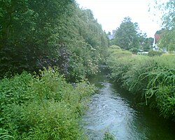
The River Wye is a river in Buckinghamshire, England. It takes its name from the town of High Wycombe through which it flows, rather than the town being named after the river, as is more commonly the case. [1]

Contents

Around 10.5 miles (16.9 km) in length, [2] the Wye rises close to West Wycombe village in the Chiltern Hills and flows through High Wycombe before emptying into the River Thames at Bourne End, on the reach above Cookham Lock. In particularly wet years, the source can temporarily change and effectively extend the river by another mile, due to a chalk spring rising above the ground in a field further up the same valley. The River Wye now runs in underground culverts through the centre of High Wycombe. [3] Pann Mill watermill, at the eastern end of Wycombe, is the last remaining watermill on the river. [4]

History

There is a long history of water-mills being operated in the Wye Valley which drops about 220 feet (67 m) in its 10.5-mile (16.9 km) course. The Domesday Book records eighteen of them in the nine miles between West Wycombe and the Thames. [5] By the seventeenth century there were fulling mills as well as corn mills. A Court of Survey in 1627 lists six mills running upstream from the boundary with Wooburn Parish: the paper mill, Tredway, Loudwater, Bassetsbury, Chalfonts (Rye) and Bridge. There were by this time at least two paper mills: Glory in Wooburn Green and Hedge in Loudwater. By 1636 another paper mill had been established in the parish of West Wycombe and by 1656 another at Marsh, below Wycombe. At this time paper was made from rags and by the end of the eighteenth century more than 150 men were recorded as papermakers in the valley. In 1816 there were 32 paper mills (some of which also milled corn), four which only milled corn and one which was also a saw mill. This was when paper making reached its peak in the valley. However, the introduction of the Fourdrinier machine at the nearby Frogmore Paper Mill, which produced a continuous roll of paper, led to widespread unemployment and many families went to the cotton mills of Lancashire. In 1830 there were riots when machine wreckers broke the machines at Ash, Marsh Green and Loudwater. Twenty men were punished by penal transportation to Tasmania. [6]

Papermaking continued at the Soho and Glory mills till the end of the twentieth century, though the water-mills gave way to steam in the mid-nineteenth century. The Soho mill in Wooburn was the prime supplier of high-grade colour paper till its demise in 1984. [7]

Mills

Shown in order from highest to lowest. Note that Marsh Green to Treadway are on an extra cut parallel to Pan to Loudwater Mills. The number is that given by registration in the eighteenth century.

Name [8] RecordedLast recordNoTypeOS Ref
West Wycombe Mill13111900~sawmill (18thC) SU 8373 9415
Upper, Francis or Little Mill16811903423paper SU 8443 9400
Lower, Mill End or Fryer's Mill15051915422Corn & paper SU 8490 9384
Lord, Frog or Ball Mill17171883421Corn & paper SU 8550 9363
Ash or Lane's Mill (Broughton/Wynkle's) (2)15961895419, 420paper SU 8600 9339
Temple Mill (Gosenham)12271895corn SU 8631 9315
Bridge Mill11851932corn SU 8653 9290
Pann Mill11851967corn SU 8705 9276
Rye Mill (Bradshaw's, Sale's, Bowler's, New)13461931411paper SU 8746 9260
Bassetbury Mill14111931corn SU 8771 9240
Bowden Mill (2)12351939415, 416Corn & paper SU 8830 9220
Wycombe Marsh Mill (Lower Marsh)11331993414paper SU 8880 9195
King's Mill (New)17251939417paper SU 8746 9260
Loudwater Mill (2)14831939430, 431paper SU 9014 9079
Snakely or Ford's Mill17671970428paper SU 9027 9036
Hedge Mill12351970427Corn & paper SU 9042 9012
Marsh Green or Upper Marsh Mill17501816412Corn & paper SU 8790 9212
Beech Mill17401900413paper SU 8881 9155
Treadway Mill (Overshot's)16821854418Corn & paper SU 8999 9056
Clapton Mill14921922429, 509Corn, metal & paper SU 9100 8997
Glory Mill (2)12352000426Corn & paper SU 9130 8950
Lower Glory Mill16311907425Corn & paper SU 9160 8895
Soho Mill17051988424Corn & paper SU 9080 8770
Prince's Mill (Egham Green) (3)17301865287, 288, 289Corn & paper SU 9009 8736
Gunpowder Mill (Jackson's)17051980286Corn & paper SU 8978 8717
Hedsor Mill14921980285Corn & paper SU 8962 8670
Lower Bourne End Mill17191895284Corn & paper SU 8948 8643

See also

Related Research Articles

<span class="mw-page-title-main">High Wycombe</span> Town in Buckinghamshire, England

High Wycombe, often referred to as Wycombe, is a market town in Buckinghamshire, England. Lying in the valley of the River Wye surrounded by the Chiltern Hills, it is 29 miles (47 km) west-northwest of Charing Cross in London, 13 miles (21 km) south-southeast of Aylesbury, 23 miles (37 km) southeast of Oxford, 15 miles (24 km) northeast of Reading and 8 miles (13 km) north of Maidenhead.

<span class="mw-page-title-main">Bourne End, Buckinghamshire</span> Village in Buckinghamshire England

Bourne End is a village mostly in the parish of Wooburn, but partly in that of Little Marlow in Buckinghamshire, England. It is about five miles (8 km) south-east of High Wycombe and three miles (5 km) east of Marlow, near the boundary with Berkshire and close to where the Buckinghamshire River Wye empties into the Thames.

<span class="mw-page-title-main">Marlow, Buckinghamshire</span> Town in Buckinghamshire, England

Marlow is a town and civil parish within the Unitary Authority of Buckinghamshire, England. It is located on the River Thames, 4 miles (6 km) south-southwest of High Wycombe, 5 miles (8 km) west-northwest of Maidenhead and 33 miles (53 km) west of central London.

<span class="mw-page-title-main">Hedsor</span> Human settlement in England

Hedsor is a small village and civil parish in Wycombe district in Buckinghamshire, England, in the very south of the county, near the River Thames and Bourne End. It is in the civil parish of Wooburn.

<span class="mw-page-title-main">Loudwater, Buckinghamshire</span> Human settlement in England

Loudwater is a village in the parish of Chepping Wycombe in Buckinghamshire, England. It is located in the valley to the east of High Wycombe, on the A40 London Road.

<span class="mw-page-title-main">Wooburn</span> Human settlement in England

Wooburn is a large village in Buckinghamshire, England. It is located off the A4094 road between Wooburn Green and Bourne End in the very south of the county near the River Thames, about two miles south west of Beaconsfield and four miles east of Marlow. Wooburn is one of the two principal settlements within Wooburn, a civil parish in Wycombe district.

<span class="mw-page-title-main">River Darent</span> River in Kent, England

The Darent is a Kentish tributary of the River Thames and takes the waters of the River Cray as a tributary in the tidal portion of the Darent near Crayford. 'Darenth' is frequently found as the spelling of the river's name in older books and maps, Bartholomew's Canals and River of England being one example. Bartholomew's Gazetteer (1954) demonstrates that Darent means "clear water", a result of it springing from and running through chalk. The purity of the water was a major factor in the development of paper and pharmaceuticals in the area.

<span class="mw-page-title-main">Chepping Wycombe</span> Human settlement in England

Chepping Wycombe is a civil parish in the ceremonial county of Buckinghamshire, England. The parish includes the three large villages of Tylers Green, Loudwater, and Flackwell Heath. The central part of the parish comprises extensive business and industrial development lying adjacent and underneath an elevated section of the M40 in the valley of the River Wye.

<span class="mw-page-title-main">Beaconsfield (UK Parliament constituency)</span> Parliamentary constituency in the United Kingdom since 1974

Beaconsfield is a constituency in Buckinghamshire represented in the House of Commons of the UK Parliament since 2019 by Joy Morrissey of the Conservative Party. She succeeded Independent and former Conservative Dominic Grieve, whom she defeated following his suspension from the party. The constituency was established for the February 1974 general election.

<span class="mw-page-title-main">Marlow branch line</span>

The Marlow branch line is a single track railway line in England, between Maidenhead station in Berkshire and Bourne End and Marlow stations in Buckinghamshire. It is 7 miles 10 chains (11.5 km) in length. Passenger services are operated by Great Western Railway using Class 165 and Class 166 diesel trains. The line connects to the Great Western Main Line at Maidenhead; it uses a section of the former Wycombe Railway line to High Wycombe together with the former Great Marlow Railway.

<span class="mw-page-title-main">Wycombe Marsh</span> Human settlement in England

Wycombe Marsh is an area of High Wycombe, Buckinghamshire, England. It lies on the River Wye and the A40 road, approximately 1.5 miles (2.4 km) south-east of High Wycombe town centre, and approximately 1 mile (1.6 km) north-west of Loudwater. Wycombe Marsh is in the Ryemead ward of High Wycombe, which had a population of 7,188 at the 2011 census.

<span class="mw-page-title-main">Wooburn Green</span> Human settlement in England

Wooburn Green is a village in the civil parish of Wooburn, Buckinghamshire, England.

The Wycombe Railway was a British railway between Maidenhead and Oxford that connected with the Great Western Railway at both ends; there was one branch, to Aylesbury.

<span class="mw-page-title-main">Wooburn Green railway station</span> Former railway station in England

Wooburn Green railway station was a railway station which served Wooburn Green, Buckinghamshire, England, on the Wycombe Railway. It was opened in 1854, with the station located near the bottom of Whitepit lane. The station became a halt in 1968 because of a decreased service on the line.

<span class="mw-page-title-main">River Bourne, Kent</span> River in Kent, England

The River Bourne rises in the parish of Ightham, Kent and flows in a generally south easterly direction through the parishes of Borough Green, Platt, Plaxtol, West Peckham, Hadlow, and East Peckham where it joins the River Medway. In the 18th century the river was known as the Busty or Buster, the Shode or Sheet, but is not known by these names nowadays. A bourne is a type of stream, while shode means a branch of a river.

<span class="mw-page-title-main">River Wey</span> River in southern England

The River Wey is a main tributary of the River Thames in south east England. Its two branches, one of which rises near Alton in Hampshire and the other in West Sussex to the south of Haslemere, join at Tilford in Surrey. Once combined, the flow is eastwards then northwards via Godalming and Guildford to meet the Thames at Weybridge. Downstream the river forms the backdrop to Newark Priory and Brooklands. The Wey and Godalming Navigations were built in the 17th and 18th centuries, to create a navigable route from Godalming to the Thames.

Wooburn, or Wooburn and Bourne End, is a civil parish in Buckinghamshire, England. South-east of High Wycombe, it comprises the villages of Wooburn, Wooburn Green and Bourne End and the hamlets of Berghers Hill, Cores End, Hawks Hill, Widmoor and Wooburn Moor. The Buckinghamshire River Wye flows through the area, emptying into the River Thames at Bourne End.

<span class="mw-page-title-main">Warren Nature Reserve</span> Local nature reserve in Buckinghamshire, England

Warren Nature Reserve is a 2.3 hectares Local Nature Reserve in Wooburn in Buckinghamshire. It is owned by Wycombe District Council and managed by the council together with Wooburn and Bourne End parish council.

References

  1. High Wycombe#History
  2. "About the Wye | Revive the Wye".
  3. Bucks Free Press River Clean-up Project gets Underway 1 October 2008
  4. Pann Mill Watermill
  5. L. John Mayes (1985). "Paper in the Wye Valley". In G T Mandl (ed.). Three Hundred Years in Paper. London:G T Mandl.
  6. "Brief History of High Wycombe". Buckinghamshire County Council. Archived from the original on 25 May 2011. Retrieved 7 July 2010.
  7. "Wooburn and Bourne End Parish Council" . Retrieved 8 July 2010.
  8. Alan Mead (1999), Days of Glory, Far Out Publications
Next confluence upstream River Thames Next confluence downstream
Hennerton Backwater River Wye, Buckinghamshire York Stream (south)