
Oxfordshire is a ceremonial county in South East England. The county is bordered by Northamptonshire and Warwickshire to the north, Buckinghamshire to the east, Berkshire to the south, and Wiltshire and Gloucestershire to the west. The city of Oxford is the largest settlement and county town.

Haddenham is a village and civil parish in west Buckinghamshire, England. It is about 5 miles (8 km) south-west of Aylesbury and 4 miles (6 km) north-east of Thame in neighbouring Oxfordshire. At the 2011 Census, the population of the civil parish was 4,502.
Botolph Claydon is a hamlet in the civil parish of East Claydon, in Buckinghamshire, England. It is situated about 9 miles (14 km) east of Bicester in Oxfordshire, and 7 miles (11 km) north west of Aylesbury.
Chearsley is a village and civil parish within the Buckinghamshire district in the ceremonial county of Buckinghamshire, England. It is situated about seven miles south west of Aylesbury, and about four miles north of Thame, in Oxfordshire.

Thame is a market town and civil parish in Oxfordshire, about 13 miles (21 km) east of the city of Oxford and 10 miles (16 km) southwest of Aylesbury. It derives its name from the River Thame which flows along the north side of the town and forms part of the county border with Buckinghamshire. The parish includes the hamlet of Moreton south of the town. The 2011 Census recorded the parish's population as 11,561. Thame was founded in the Anglo-Saxon era and was in the kingdom of Wessex.

Little Missenden is a village and civil parish on the River Misbourne in Buckinghamshire, England. It is in the Chiltern Hills, about 3 miles (5 km) southeast of Great Missenden and 3 miles (5 km) west of Amersham. The village lies on the River Misbourne in the Misbourne valley.

Dorchester on Thames is a village and civil parish in Oxfordshire, about 3 miles (5 km) northwest of Wallingford and 8 miles (13 km) southeast of Oxford. The town is a few hundred yards from the confluence of the River Thames and River Thame. A common practice of the scholars at Oxford was to refer to the river Thames by two separate names, with Dorchester on Thames the point of change. Downstream of the village, the river continued to be named The Thames, while upstream it was named The Isis. Ordnance Survey maps continued the practice by labelling the river as "River Thames or Isis" above Dorchester, however, this distinction is rarely made outside the city of Oxford.
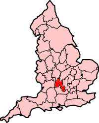
The county of Oxfordshire in England was formed in the early years of the 10th century and is broadly situated in the land between the River Thames to the south, the Cotswolds to the west, the Chilterns to the east and The Midlands to the north, with spurs running south to Henley-on-Thames and north to Banbury.

Culham is a village and civil parish in a bend of the River Thames, 1 mile (1.6 km) south of Abingdon in Oxfordshire. The parish includes Culham Science Centre and Europa School UK. The parish is bounded by the Thames to the north, west and south, and by present and former field boundaries to the east. It is low-lying and fairly flat, rising from the Thames floodplain in the south to a north-facing escarpment in the north up to 260 feet (80 m) above sea level. The 2011 Census recorded its population as 453.

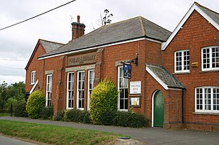
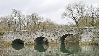
Waterstock is a village and civil parish on the River Thame about 4.5 miles (7 km) west of the market town of Thame in Oxfordshire. The parish is bounded to the north and west by the river, to the south largely by the A418 main road, and to the east largely by the minor road between Tiddington and Ickford Bridge across the Thame. On the north side of the parish, the river forms the county boundary with Buckinghamshire as well as the parish boundary with Ickford and Worminghall. Waterstock village is on a minor road north of the A418 and is surrounded by open farming land. In the village are about 50 houses and a farm along one main street.
Wheatley is a village and civil parish in South Oxfordshire, England, about 5 miles (8 km) east of Oxford. The parish includes the hamlet of Littleworth, which is west of Wheatley.

Clifton Hampden is a village and civil parish on the north bank of the River Thames, just over 3 miles (5 km) east of Abingdon in Oxfordshire. Since 1932 the civil parish has included the village of Burcot, 1 mile (1.6 km) east of Clifton Hampden. The 2011 Census recorded the parish population as 662.

Berinsfield is an English village and civil parish in South Oxfordshire, about 7 miles (11 km) southeast of Oxford. The 2011 Census recorded the parish population as 2,806.

"The Isis" is an alternative name for the River Thames, used from its source in the Cotswolds until it is joined by the Thame at Dorchester in Oxfordshire. The modern form of the name, first recorded c.1540, relates to the Egyptian goddess Isis. The deity was venerated throughout the Roman Empire, and was worshipped at the Temple of Isis – near the Thames in Londinium – during the Roman occupation. Notably, the Isis flows through the city of Oxford.

The Abbey Church of St Peter and St Paul, more usually called Dorchester Abbey, is a Church of England parish church in Dorchester on Thames, Oxfordshire, about 8 miles (13 km) southeast of Oxford. It was formerly a Norman abbey church and was built on the site of a Saxon cathedral.
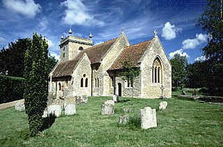
Stadhampton is a village and civil parish about 7 miles southeast of Oxford in South Oxfordshire, England. Stadhampton is close to the River Thame, a tributary of the River Thames. The village was first mentioned by name in 1146, and was in the ownership of the bishops of Lincoln, the crown, and various Oxford colleges for most of subsequent history. The village includes several buildings of historical and architectural interest, including a parish church with features dating back to the 12th-century.

Benson Lock is a lock on the River Thames in England, close to Benson, Oxfordshire but on the opposite bank of the river. The first pound lock here was built by the Thames Navigation Commission in 1788 and it was replaced by the present masonry lock in 1870. The distance between Benson Lock and Cleeve Lock downstream is 6.5 miles (10.4 km) - the longest distance between locks on the River Thames.

Chiselhampton is a village in the civil parish of Stadhampton, on the River Thame, in the South Oxfordshire district, in the county of Oxfordshire, England. It is about 6 miles (10 km) southeast of Oxford. In 1931 the parish named Chislehampton had a population of 136. On 1 April 1932 the parish was abolished and merged with Stadhampton.

Andersey Island is a 273-acre (110.5 ha) area of flood-meadow and former flood-meadow south-east of Abingdon Bridge, Abingdon, Oxfordshire on the reach above Culham Lock in which parish it lies however maintaining close links with Abingdon by virtue of its current amenities. It is the second-largest island of the non-tidal course of the River Thames in England upstream of the Tideway — if disqualifying the villages of Dorney and Eton, Berkshire enclosed by the engineered Jubilee River. Andersey means Andrew's island after its chapel to St Andrew, demolished, built about 1050 CE.
The Swift Ditch is a 2 km (1.2 mi) long artificial channel that formed a short-cut for river traffic to and from Oxford, across a meander of the River Thames in England. It was formerly the primary navigation channel. With the main river, it creates Andersey Island on the left bank of the Thames opposite Abingdon-on-Thames. Within a poem published in 1632, the Water Poet John Taylor wrote:
At Abingdon the shoals are worse and worse
That Swift Ditch seems to be the better course

