Cookham Lock

Last updated

Cookham Lock
Cookham Lock, Berkshire.JPG
Cookham Lock, Berkshire
Cookham Lock
Waterway River Thames
County Berkshire
Maintained by Environment Agency
OperationHydraulic
First built1830
Latest built1957
Length55.77 m (183 ft 0 in) [1]
Width7.62 m (25 ft 0 in) [1]
Fall1.30 m (4 ft 3 in) [1]
Above sea level81'
Distance to
Teddington Lock
33 miles
Cookham Lock
BSicon uSTR.svg
River Thames
BSicon uexSTR+l.svg
BSicon uWEIRl.svg
BSicon uexSTR.svg
BSicon uFGATEu.svg
Marlow Lock
BSicon uexSTRl.svg
BSicon ueABZg+r.svg
BSicon uexSTR+l.svg
BSicon ueABZgr.svg
BSicon uexSKRZ-Au.svg
BSicon uSKRZ-Au.svg
A404 Marlow By-pass Bridge
BSicon uexSTRl.svg
BSicon ueABZg+r.svg
BSicon uxISLAND.svg
Gibraltar Islands
BSicon uxISLAND.svg
BSicon umKRZu.svg
Bourne End Railway Bridge
BSicon ueABZg+l.svg
BSicon uexSTRq.svg
River Wye
BSicon uexSTR+l.svg
BSicon uexSTRq.svg
BSicon uexSTRq.svg
BSicon POINTERg@fq.svg
BSicon ueTEEnr.svg
Fleet River
BSicon uexSTR.svg
BSicon uSKRZ-Au.svg
A4094 Cookham Bridge
BSicon uexSTR.svg
BSicon uWEIRr.svg
BSicon uexSTR+r.svg
weir
BSicon uexSTR.svg
BSicon uexSTR+l.svg
BSicon uexABZq+l.svg
BSicon ueABZgr.svg
BSicon ueWHRF.svg
Hedsor Wharf
BSicon uexSTR.svg
BSicon uxWEIRg.svg
BSicon uexSTR.svg
BSicon uSTR.svg
BSicon uSTR.svg
weir
BSicon uexSTR.svg
BSicon uexSKRZ-Eu.svg
BSicon uSKRZ-Eu.svg
BSicon uSTR.svg
bridges
BSicon uexSTR.svg
BSicon uexSTR.svg
BSicon uxWEIRg.svg
BSicon uFGATEu.svg
BSicon uSTR.svg
Cookham Lock
BSicon uexSTR.svg
BSicon uexSTR.svg
BSicon uxABZg+l.svg
BSicon uABZqr.svg
BSicon uSTRr.svg
BSicon uexSTR.svg
BSicon uexSTRl.svg
BSicon ueABZg+r.svg
Formosa Island
BSicon POINTERg@fq.svg
BSicon uexSTR.svg
BSicon uSTR.svg
Strand Water
BSicon uSTR.svg
River Thames

Cookham Lock is a lock with weirs situated on the River Thames near Cookham, Berkshire, about a half-mile downstream of Cookham Bridge. The lock is set in a lock cut which is one of four streams here and it is surrounded by woods. On one side is Sashes Island and on the other is Mill Island connected to Formosa Island, the largest on the non-tidal Thames.

Contents

There are several weirs nearby. Hedsor weir was placed across the old navigation channel in 1837, seven years after the lock was opened. There is a lower weir, and Odney weir is on the channel next to Formosa Island.

A short distance away from the lock is Odney, with the Odney Club situated on an ait. Navigation to the Odney Club by boat is possible, but is extremely difficult due to the shallow waters. It is thought that this is deliberate - to disallow non-members from entering the club site without paying the entrance fees.

History

The navigation route was formerly down Hedsor Water and the only weir was associated with the mill. After the building of Marlow Lock in 1773 there were problems with shallow water upstream of Cookham, and the earliest suggestions were for a stop at Cookham to hold the water back. In 1794 it was considered one of the most dangerous parts on the river, mainly on account of chalk boulders falling into the Thames. Plans for a lock and cut were formulated in 1807, but seven years later, the City of London were complaining that no action had been taken. [2] In 1826, a barge carrying stone for Westminster ran aground, swung across the channel, and broke in two, resulting in the loss of the cargo, valued at 40 pounds. Finally, a cut and lock were agreed upon in 1829, the cut going through the northernmost island called The Sashes. Part of the cut was formed from an existing Sashes Stream, and an Ait was removed at the lower end of the cut. The cut modified and elongated the Mill Eyot which was joined with the south eastern corner of The Sashes. [3] The lock opened on 1 November 1830, but no weir was built at this time. [4] The lock and cut cost £8,400 to construct, and the fall on the lock was about 2 feet (0.6 m). [5]

When the lock was built, the access to the lock on travelling upstream from Boulters Lock, was originally a towpath ferry (My Lady ferry or Lower Cookham ferry) crossing to Cliveden, [6] a Middle ferry crossing from Cliveden to the downstream end of Cookham lock island [7] and finally the Cookham Upper ferry from the upstream end of the lock island to Cookham village. [8]

In 1832 Lord Boston of Hedsor House claimed compensation for loss of towpath rights along Hedsor Water which he was granted. [9] In 1837 a weir was found necessary and built, as a cost of £650. It doubled the fall on the lock to around 4 feet (1.2 m). [5] The construction led to further litigation from Lord Boston for loss of trade to the wharf he owned there. This time the only compensation he received was the building of a flash lock in the weir. [10] This was removed when the lock was rebuilt in 1869, as Lord Boston had built eel bucks in the stream in the meantime. [11]

The lock was rebuilt in 1957.

Access to the lock

There is a road from Cookham to Formosa Island and the lock; the road is public for pedestrians, but gated for authorised vehicles only. Access from the Thames Path requires a near 1 km walk across Odney Common on Formosa Island and Mill Eyot to Sashes Island, returning by the same route; the Thames Path bypasses the lock and islands due to several historic ferries no longer operating.

Reach above the lock

Water meadows above Cookham CookhamLockReach02.JPG
Water meadows above Cookham
Wooded hillsides by the river CookhamLockReach01.JPG
Wooded hillsides by the river

Before the streams split above the lock, the river is crossed by Cookham Bridge. Along the reach on the Buckinghamshire bank is Bourne End where the River Wye joins the Thames. Bourne End Railway Bridge, which includes a footbridge, crosses the river here. Along the Berkshire bank there are water meadows. There are navigation transit markers just downstream of Bourne End Railway Bridge, to allow river users to check their speed.

Further upstream towards the Berkshire bank are the Gibraltar Islands which lie in front of Quarry Wood. There are then steep hills overhanging the river at Cookham Dean where the house called "The Mount", where Kenneth Grahame lived as a child is situated. He based much of his book on this part of the Thames which is described as The Wind in the Willows country.

As the ground levels, the Marlow By-pass Bridge crosses the river a little way downstream of Marlow Lock.

Thames Path

A view of the tail (downstream) lock gates and the banks of the Cliveden Reach beyond. CookhamLock01.JPG
A view of the tail (downstream) lock gates and the banks of the Cliveden Reach beyond.

The Thames Path, which has passed through Cookham rather than by the lock, runs from Cookham Bridge along the southern bank until Bourne End Railway Bridge, where there is a footbridge. The path crosses this footbridge and then goes along the northern bank to Marlow. The nearest point on the Thames Path is a little under 1 km away from the lock and a walk across Formosa Island is necessary to visit the lock.

Literature and the media

Cookham was home to the artist Stanley Spencer whose works include Swan Upping at Cookham.

Composer John David Davis wrote his Idyl for string quartet, Op. 50, sub-titled Summer's Eve at Cookham Lock, in 1916. [12]

Season 1 Episode 1 of the TV series The Saint, 'The Talented Husband', starring Roger Moore, is set in Cookham, with shots of the nearby Thames reach and railway station.

See also

Next lock upstream River Thames Next lock downstream
Marlow Lock
6.44 km (4.00 mi) [13]
Cookham Lock
Grid reference: SU906855
Boulter's Lock
3.35 km (2.08 mi) [13]

Related Research Articles

<span class="mw-page-title-main">Locks and weirs on the River Thames</span>

The English River Thames is navigable from Cricklade or Lechlade to the sea, and this part of the river falls 71 meters (234 feet). There are 45 locks on the river, each with one or more adjacent weirs. These lock and weir combinations are used for controlling the flow of water down the river, most notably when there is a risk of flooding, and provide for navigation above the tideway.

<span class="mw-page-title-main">Teddington Lock</span> Series of locks on the River Thames in London

Teddington Lock is a complex of three locks and a weir on the River Thames between Ham and Teddington in the London Borough of Richmond upon Thames, England. Historically in Middlesex, it was first built in 1810.

<span class="mw-page-title-main">Caversham Lock</span> Lock and weir on the River Thames in Berkshire, England

Caversham Lock is a lock and main weir on the River Thames in England at Reading, Berkshire. Both the lock and main weir are connected to De Bohun Island. The Thames Navigation Commissioners built the original lock in 1778. Additional sluices north of View Island and Heron Island form the whole weir complex. A footbridge passes over all three islands to connect Lower Caversham to Reading via a route other than George Street and Reading Bridge.

<span class="mw-page-title-main">Marsh Lock</span> Lock and weir on the River Thames in Berkshire, England

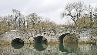
Marsh Lock is a lock and weir situated on the River Thames in England, about 1 mile upstream of Henley Bridge in Henley-on-Thames, Oxfordshire. The lock is close to the Berkshire bank, but accessed from the Oxfordshire side via two long walkways, the downstream one being near Mill Meadows. The first pound lock was built by the Thames Navigation Commission in 1773.

<span class="mw-page-title-main">Bray Lock</span> Lock and weir on the River Thames in Buckinghamshire, England

Bray Lock is a lock and weir on the River Thames in England near Bray and Dorney Reach, and is just above the M4 Bridge across the Thames. The lock is on the Buckinghamshire side of the river on the opposite bank from Bray itself and Maidenhead which are in Berkshire. Here, the county line stands roughly halfway between the lock and the opposite bank, following the course of the Thames itself. The pound lock was built by the Thames Navigation Commission relatively late, in 1845. The lock keeper's cottage is on an island between the lock and the weir.

<span class="mw-page-title-main">Cookham</span> Village in Berkshire, England

Cookham is a historic Thames-side village and civil parish on the north-eastern edge of Berkshire, England, 2.9 miles (5 km) north-north-east of Maidenhead and opposite the village of Bourne End. Cookham forms the southernmost and most rural part of the High Wycombe urban area. With adjoining Cookham Rise and Cookham Dean, it had a combined population of 5,779 at the 2011 Census. In 2011, The Daily Telegraph deemed Cookham Britain's second richest village.

<span class="mw-page-title-main">Thames Path</span> National Trail following the River Thames in England

The Thames Path is a National Trail following the River Thames from one of its sources near Kemble in Gloucestershire to the Woolwich foot tunnel, south east London. It is about 185 miles (298 km) long. A path was first proposed in 1948 but it only opened in 1996.

<span class="mw-page-title-main">Boulter's Lock</span> Lock and weir on the River Thames, England

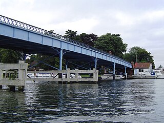
Boulter's Lock is a lock and weir on the River Thames in England north-east of Maidenhead town centre, Berkshire. The present 1912-built lock replaces those at this point of the river to the immediate east dating from the late 16th century and that of 1772 built by the Thames Navigation Commission. The lock is on the western side of the north-south flowing reach between the A4094 Maidenhead to Cookham road and Ray Mill Island. The name is variably used for the immediate surrounding area.

<span class="mw-page-title-main">Molesey Lock</span> Lock on the River Thames in Surrey, England

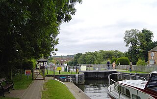
Molesey Lock is a lock on the River Thames in England at East Molesey, Surrey on the right bank.

<span class="mw-page-title-main">Cookham Bridge</span> Bridge in Cookham, Berkshire

Cookham Bridge is a road bridge in Cookham, Berkshire, carrying the A4094 road across the River Thames in England. It is on the reach above Cookham Lock and links Cookham on the Berkshire bank with Bourne End in Buckinghamshire.

<span class="mw-page-title-main">Temple Lock</span> Lock and weir on the River Thames in Buckinghamshire, England

Temple Lock is a lock and weir situated on the Buckinghamshire bank of the River Thames near Temple Mill Island opposite Temple Meadows and not far from Hurley, Berkshire. It was first built by the Thames Navigation Commissioners in 1773.

<span class="mw-page-title-main">Marlow Lock</span> Lock and weir on the River Thames in Buckinghamshire, England

Marlow Lock is a lock and weir situated on the River Thames in the town of Marlow, Buckinghamshire, England, about 300m downstream of Marlow Bridge. The first pound lock was built by the Thames Navigation Commission in 1773.

<span class="mw-page-title-main">Sunbury Lock</span> Lock on the River Thames in Surrey, England

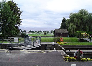
Sunbury Lock is a lock complex of the River Thames in England near Walton-on-Thames in north-west Surrey, the third lowest of forty four on the non-tidal reaches. The complex adjoins the right, southern bank about 12 mile (0.80 km) downstream of the Weir Hotel.

<span class="mw-page-title-main">Old Windsor Lock</span> Lock on the River Thames in Berkshire, England

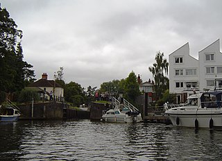
Old Windsor Lock is a lock on the River Thames in England on the right bank beside Old Windsor, Berkshire. The lock marks the downstream end of the New Cut, a meander cutoff built in 1822 by the Thames Navigation Commissioners which created Ham Island. The lock and a wider footbridge give access to the island. Two weirs are associated; the smaller adjoins and the larger is upstream. The lock is the ninth lowest of the forty-five on the river.

<span class="mw-page-title-main">Boveney Lock</span> Lock on the River Thames in Buckinghamshire, England

Boveney Lock is a lock on the River Thames situated on the Buckinghamshire bank opposite the Windsor Racecourse and close to Eton Wick. Boveney is a village a little way upstream on the same side. The lock was first built in 1838 by the Thames Navigation Commission. The lock was rebuilt in 1898 closer to the Buckinghamshire bank, and a set of boat rollers were installed on the old site.

<span class="mw-page-title-main">Shifford Lock</span> Lock on the River Thames, England

Shifford Lock is a lock on the River Thames in England. It is in the centre of a triangle formed by the small villages of Shifford, Duxford and Chimney in Oxfordshire. It is at the start of a navigation cut built with the lock by the Thames Conservancy in 1898. This was the only new lock built on the non-tidal Thames in the era of falling revenue after the Thames Conservancy took over responsibilities of the Thames Navigation Commission. It replaced a flash lock in a weir about 34 mile (1.2 km) downstream.

<span class="mw-page-title-main">Formosa Island</span>

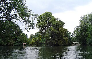
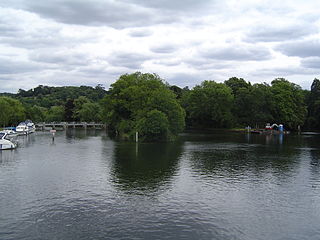
Formosa Island is an island in the River Thames in England at Cookham Lock near Cookham, Berkshire, with two smaller adjacent islands.

<span class="mw-page-title-main">Swift Ditch</span>

The Swift Ditch is a 2 km (1.2 mi) long artificial channel that formed a short-cut for river traffic to and from Oxford, across a meander of the River Thames in England. It was formerly the primary navigation channel. With the main river, it creates Andersey Island on the left bank of the Thames opposite Abingdon-on-Thames. Within a poem published in 1632, the Water Poet John Taylor wrote:

At Abingdon the shoals are worse and worse
That Swift Ditch seems to be the better course

<span class="mw-page-title-main">Hedsor Water</span>

Hedsor Water is a stretch of the River Thames near Cookham, Berkshire which runs to the north of Sashes Island. Hedsor Water was once the main navigation of the Thames but was by-passed by the construction of Cookham Lock in 1830. Navigation is only possible for the first 100 metres (330 ft) from the downstream end, where a few temporary moorings are available, except for smaller boats.

<span class="mw-page-title-main">Sashes Island</span> Island in the River Thames in Berkshire, United Kingdom

Sashes Island is an island in the River Thames in England at Cookham Lock near Cookham, Berkshire. It is now open farmland, but has Roman and Anglo-Saxon connections.

References

  1. 1 2 3 "Environment Agency Dimensions of locks on the River Thames". web page. Environmental Agency. 8 November 2012. Retrieved 18 November 2012. Dimensions given in metres
  2. Thacker 1968, p. 308.
  3. "map". River & Rowing Museum. Retrieved 28 October 2018.
  4. Thacker 1968, pp. 308, 310.
  5. 1 2 Skempton 1996, p. 171.
  6. Cliveden ferry http://thames.me.uk/s00748.htm
  7. Cookham Middle ferry (Lock ferry); Joan Tucker Ferries of the Upper Thames 2013 ISBN   978-1-84868-967-1
  8. Cookham ferry; http://thames.me.uk/s00770.htm
  9. Thacker 1968, pp. 310–311.
  10. Thacker 1968, pp. 312–313.
  11. Thacker 1968, p. 313.
  12. Dutton Vocalion
  13. 1 2 "Environment Agency Distances between locks on the River Thames". web page. Environmental Agency. 19 November 2012. Retrieved 21 November 2012. Distances given in km

Bibliography

51°33′41″N0°41′44″W / 51.5613°N 0.695442°W / 51.5613; -0.695442