Marlow Bridge is a road traffic and foot bridge over the River Thames in England between the town of Marlow, Buckinghamshire and the village of Bisham in Berkshire. It crosses the Thames just upstream of Marlow Lock, on the reach to Temple Lock. The bridge is a Grade I listed building.

Cookham Lock is a lock with weirs situated on the River Thames near Cookham, Berkshire, about a half-mile downstream of Cookham Bridge. The lock is set in a lock cut which is one of four streams here and it is surrounded by woods. On one side is Sashes Island and on the other is Mill Island connected to Formosa Island, the largest on the non-tidal Thames.

The Thames Path is a National Trail following the River Thames from its source near Kemble in Gloucestershire to the Thames Barrier at Charlton, south east London. It is about 184 miles (296 km) long. A path was first proposed in 1948 but it only opened in 1996.

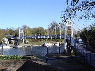
The Teddington Lock Footbridges are two footbridges over the River Thames in England, situated just upstream of Teddington Lock at Teddington. There is a small island between the bridges.

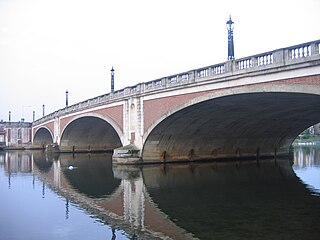
Hampton Court Bridge is a Grade II listed bridge that crosses the River Thames in England approximately north–south between Hampton, London and East Molesey, Surrey, carrying the A309. It is the upper of two road bridges on the reach above Teddington Lock and downstream of Molesey Lock.

The A308 is a road in England in two parts. The first part runs from Central London to Putney Bridge. The second part runs from just beyond Putney Heath to Bisham, Berkshire. It traces four, roughly straight lines, to stay no more than 3 miles (4.8 km) from the Thames. It is a dual carriageway where it is furthest from that river, in Spelthorne, Surrey and forms one of the motorway spurs to the large town of Maidenhead. Other key settlements served are Fulham, Kingston (London), Staines upon Thames, Windsor and a minor approach to Marlow

The Queen Elizabeth Bridge is a road bridge just to the west of the town of Windsor, Berkshire, England.

The A307 road runs 13.2 miles (21.2 km) through SW London and NW Surrey. It is primary at the north-east end; the remainder is non-primary, generally superseded in the mid-twentieth century in two stages by newer alignments of the Portsmouth Road, the Kingston bypass and Esher bypass of the A3, which runs along a slightly oblique axis.

Bourne End Railway Bridge is a railway bridge carrying the Marlow Branch Line, and a footpath over the River Thames in Bourne End, Buckinghamshire, England. It crosses the Thames on the reach between Cookham Lock and Marlow Lock.

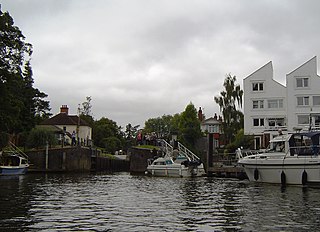
Marlow Lock is a lock and weir situated on the River Thames in the town of Marlow, Buckinghamshire, England, about 300m downstream of Marlow Bridge. The first pound lock was built by the Thames Navigation Commission in 1773.

Albert Bridge is a road bridge in England running north–south and carrying the B3021 between Datchet and Old Windsor. It crosses the River Thames on the reach between Old Windsor Lock and Romney Lock. It was rebuilt in brick in 1927 to replace a cast-iron bridge built in 1850–51.

Victoria Bridge is a road bridge running north–south between Datchet and Windsor, Berkshire, England. It crosses the River Thames on the reach between Old Windsor Lock and Romney Lock. It was rebuilt in 1967 to replace a damaged bridge.

Osney Lock is a lock on the River Thames in Oxford, England, where the village or island of Osney is next to the river.

Radcot Lock is a lock on the River Thames in England just downstream of Radcot, Oxfordshire, on the southern bank.

National Cycle Route 1 is a route of the National Cycle Network, running from Dover to Tain. The 1,022 km-long (635-mile) cycle-path is located in the United Kingdom.

Black Potts Railway Bridge carries the railway from London (Waterloo) to Windsor, Berkshire across the River Thames. The Staines to Windsor & Eton Line terminates immediately after the bridge at Windsor and Eton Riverside railway station. The bridge crosses the Thames on the reach above Old Windsor Lock, shortly before Romney Lock.

The M4 Thames Bridge Maidenhead is a motorway bridge between Dorney Reach, Buckinghamshire and Bray near Maidenhead, Berkshire in England built in the 1960s.

Temple Footbridge is a pedestrian only bridge near Hurley, Berkshire across the River Thames in England. It connects the Buckinghamshire and Berkshire banks. It crosses the Thames just above Temple Lock.

The Middlesex Filter Beds Weir, or Lea Bridge Road Weir, marks the start of the Hackney Cut, an artificial channel of the River Lee Navigation built in 1770, in the London Borough of Hackney. The weir lies between the former Middlesex Filter Beds – now a nature reserve – and the Thames Water treatment works at Lea Bridge Road.


