![]() | This article has multiple issues. Please help improve it or discuss these issues on the talk page . (Learn how and when to remove these template messages)
|
West Wycombe | |
---|---|
The Mausoleum on West Wycombe Hill | |
Location within Buckinghamshire | |
Population | 1,345 (2011 Census) [1] |
OS grid reference | SU830945 |
Civil parish |
|
Unitary authority | |
Ceremonial county | |
Region | |
Country | England |
Sovereign state | United Kingdom |
Post town | HIGH WYCOMBE |
Postcode district | HP14 |
Dialling code | 01494 |
Police | Thames Valley |
Fire | Buckinghamshire |
Ambulance | South Central |
UK Parliament | |
West Wycombe is a small village and civil parish in Buckinghamshire, England, famed for its manor houses and its hills. It is 3 miles (4.8 km) west of High Wycombe.
The historic village is largely a National Trust property and receives a large annual influx of tourists, being the site of West Wycombe Park, West Wycombe Caves and the Mausoleum on top of West Wycombe Hill. The Mausoleum and Golden Ball above West Wycombe village are impressive local landmarks, visually dominating the village and local landscape for miles surrounding.
West Wycombe Park, Caves, Mausoleum and St Lawrence's Church were all constructed in the mid-18th century by Sir Francis Dashwood, founder of the Dilettanti Society and co-founder of the notorious Hellfire Club.
The hill above West Wycombe (now the site of St Lawrence's Church and the Mausoleum) has been continuously inhabited for centuries. [3] A Bronze Age settlement is widely believed to have existed here, and research suggests there was a pagan temple in a similar style to Stonehenge. [4] The earliest known settlement is an Iron Age ditch and rampart contour camp dating from the fourth or fifth century BC. [5] A Roman settlement later occupied West Wycombe Hill, and local historians believe a temple was constructed here (though the exact site remains unknown). [4]
The next major influence on West Wycombe was the Saxons. The hillside was once again occupied, and the newly established settlement was named Hæferingdune (Hill of Hæfer's people in Old English). The name later evolved into Haveringdon. The site retained religious importance: a church is said to have been erected by St Birinus (who had become the bishop of the West Saxons in AD 634).
A Norman watch tower is also said to have been built on top of the hill.
Haveringdon's population is believed to have been greatly reduced by the Bubonic Plague (Black Death) in the 1340s. By the 18th century the village had been resited in the valley along the Oxford Road, and renamed due to its geographical features and position: "West" because it was west of High Wycombe. Both settlements are in the Wye Valley and the word "Combe" derives from the Old English/Brythonic word for "valley". According to local records there were just two ratepayers left in Haveringdon in the 19th century.
In the mid 18th century Sir Francis Dashwood commissioned an ambitious project to supply chalk for a three-mile straight road between West Wycombe and High Wycombe, now part of the A40 road, then a prominent trade route between London, Oxford, and Gloucester and onward to South Wales. The local chalk cave which had been in the village since prehistoric times was expanded into an elaborate network of tunnels and passages. The design of the caves was mostly inspired by Dashwood's Grand Tour of Italy, Greece and the Ottoman Empire. Local villagers, impoverished after a series of harvest failures, were paid a shilling per day to tunnel underground to mine chalk. The caves were all excavated by hand and even today they are viewed as an incredible feat of engineering.
Dashwood's family home, West Wycombe House, also underwent major alterations at this time. Although Haveringdon had all but disappeared by then, the church and tower had remained and a centre section was built to join the two together. The Mausoleum was also constructed, based on the design of the Constantine Arch in Rome. The new church was named Saint Lawrence's, as it was common for churches built on Pagan sites to have this name. The church and Mausoleum were also built using chalk and flint from the caves.
During this time, Dashwood and other high-powered politicians and society members formed a club then known as The Knights of St. Francis (which was later named as the Hellfire Club by a London newspaper). They first used Medmenham Abbey, eight miles away from West Wycombe on the River Thames, but the caves were later used for the club's meetings. The club was notorious in its day for orgies and black magic, but had disbanded by 1763 (according to church records). The caves fell into disuse and disrepair.
In 1929 West Wycombe village was put up for sale by the Dashwood family to raise cash following that year's Wall Street Crash. It was bought in its entirety by the Royal Society for the Encouragement of Arts, Manufactures and Commerce (better known as the Royal Society of Arts, or simply the RSA) as part of the Society's "Campaign for the Preservation of Ancient Cottages". In 1934, after extensive repairs, the Society handed the property over to the National Trust. The National Trust markets this property under the name 'West Wycombe Village and Hill'. The property features many buildings of architectural value which were built between the 16th and 18th centuries.
Between 1862 and 1958 the village was served by West Wycombe railway station, to the east of the village, on the Chiltern Main Line between London and Birmingham.
In the late 1940s and early 1950s the caves underwent extensive repairs under the auspices of the Dashwood family and turned into a tourist attraction. The profit earned was used to renovate the dilapidated West Wycombe Park. The caves continue to thrive as a popular tourist attraction today and have received over 2 million visitors since their reopening in 1951.
Although it is on the busy A40, the village centre retains much of its historical charm. It is mainly owned by the National Trust, and so has resisted modernisation. The High Street has a number of 'old-fashioned' shops (in appearance at least), as well as three pubs, some small offices and a well-used village hall. Just off the High Street is the village primary school (Reception to Year 6), a traditional furniture maker and a band hall. The population is around 1,300. [1]
St Lawrence’s Church was until the mid 18th century a medieval building. Between 1752 and 1762 it was rebuilt for Sir Francis Dashwood by the architect John Donowell. The interior was inspired by the Temple of the Sun at Palmyra; the church tower is topped by a large golden globe which originally contained seating for eight people. [6]
The Swan is a Grade II listed public house. [7] It is on the Campaign for Real Ale's National Inventory of Historic Pub Interiors. [8] Built in the 18th century, The Swan was refitted and extended in 1932 by Wheelers Wycombe brewery. [9]
West Wycombe is also a civil parish in Wycombe district.
"Hellfire club" was a term used to describe several exclusive clubs for high-society rakes established in Britain and Ireland in the 18th Century. The name most commonly refers to Francis Dashwood's Order of the Friars of St. Francis of Wycombe. Such clubs, rumour had it, served as the meeting places of "persons of quality" who wished to take part in what were socially perceived as immoral acts, and the members were often involved in politics. Neither the activities nor membership of the clubs are easy to ascertain. The clubs allegedly had distant ties to an elite society known only as "The Order of the Second Circle".
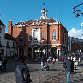
High Wycombe, often referred to as Wycombe, is a market town in Buckinghamshire, England. Lying in the valley of the River Wye surrounded by the Chiltern Hills, it is 29 miles (47 km) west-northwest of Charing Cross in London, 13 miles (21 km) south-southeast of Aylesbury, 23 miles (37 km) southeast of Oxford, 15 miles (24 km) northeast of Reading and 8 miles (13 km) north of Maidenhead.
The Hellfire Caves are a network of man-made chalk and flint caverns which extend 260m underground. They are situated above the village of West Wycombe, at the southern edge of the Chiltern Hills near High Wycombe in Buckinghamshire, Southeast England.
The Chiltern Hills are a chalk escarpment in southern England, northwest of London, covering 660 square miles (1,700 km2) across Oxfordshire, Buckinghamshire, Hertfordshire, and Bedfordshire, stretching 45 miles (72 km) from Goring-on-Thames in the southwest to Hitchin in the northeast. The hills are 12 miles (19 km) at their widest.
Duxford is a village in Cambridgeshire, England, about 10 miles (16 km) south of Cambridge. It is part of the Hundred Parishes area.
Hughenden Valley is an extensive village and civil parish in Buckinghamshire, England, just to the north of High Wycombe. It is almost 8,000 acres (32 km2) in size, divided mainly between arable and wooded land. It is situated 3 miles (4.8 km) north of central Wycombe, 12.5 miles (20.1 km) south of the county town of Aylesbury and some 35 miles (56 km) west-northwest of London.
Downley is a village and civil parish in Buckinghamshire, England, which was included in Wycombe district before its abolition. It is high in the Chiltern Hills, overlooking the town of High Wycombe, although today it is almost indistinguishable from the urban spread of the latter town.
Medmenham is a village and civil parish in south-west Buckinghamshire, England. It is on the River Thames, about 3+1⁄2 miles (5.6 km) southwest of Marlow and 3 miles (4.8 km) east of Henley-on-Thames. The parish also includes Danesfield, a housing estate predominantly for RAF officers, although families of other ranks from the RAF, Royal Navy and British Army also live there.
Radnage is a village and civil parish in the Buckinghamshire district of Buckinghamshire, England. It is in the Chiltern Hills about two miles north east of Stokenchurch and six miles WNW of High Wycombe.
Stokenchurch is a village and civil parish in south-west Buckinghamshire, England. It is located in the Chiltern Hills, about 3 miles (5 km) south of Chinnor in Oxfordshire and 6 miles (10 km) west of High Wycombe. Stokenchurch is a commuter village, served by junction 5 of the M40 motorway to London, Oxford and Birmingham. The Stokenchurch BT Tower, to the west of the village, is a highly visible landmark on the edge of the Chilterns and pinpoints the village's location for miles ahead.
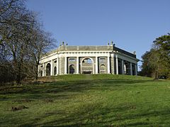
West Wycombe Park is a country house built between 1740 and 1800 near the village of West Wycombe in Buckinghamshire, England. It was conceived as a pleasure palace for the 18th-century libertine and dilettante Sir Francis Dashwood, 2nd Baronet. The house is a long rectangle with four façades that are columned and pedimented, three theatrically so. The house encapsulates the entire progression of British 18th-century architecture from early idiosyncratic Palladian to the Neoclassical, although anomalies in its design make it architecturally unique. The mansion is set within an 18th-century landscaped park containing many small temples and follies, which act as satellites to the greater temple, the house.
Francis Dashwood, 11th Baron le Despencer, PC, FRS was an English politician and rake, Chancellor of the Exchequer (1762–1763) and founder of the Hellfire Club.
Piddington is a hamlet in the parish of Piddington and Wheeler End in Buckinghamshire, England. It is located on the main A40 between Stokenchurch and West Wycombe.
Wheatley is a village and civil parish in South Oxfordshire, England, about 5 miles (8 km) east of Oxford. The parish includes the hamlet of Littleworth, which is immediately to the west of Wheatley village. The 2011 census recorded the parish population as 3,913.
Welton is a village and civil parish in the East Riding of Yorkshire, England. The parish extends to the bank of the Humber Estuary at its southern extreme, and into the Yorkshire Wolds in the northern part. The A63 road and Hull to Selby railway line both bisect the parish east–west, south of Melton and Welton.
Lewknor is a village and civil parish about 5 miles (8 km) south of Thame in Oxfordshire.The civil parish includes the villages of Postcombe and South Weston. The 2011 Census recorded the parish's population as 663.
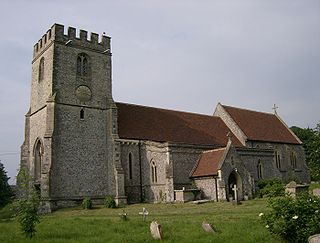
St Lawrence's Church is a Church of England church in the parish of West Wycombe, Buckinghamshire, England. It sits on top of West Wycombe Hill in a prominent position overlooking the West Wycombe Road, and surrounding villages. West Wycombe Hill is managed by the National Trust, although the church and graveyard are owned by the Church of England. The church resides in the Chilterns Area of Outstanding Natural Beauty. St Lawrence Church and the mausoleum both occupy similar positions on top of West Wycombe Hill, and the Church tower is visible for many miles around. The top of the tower is the highest point in the Southern Chilterns and on a clear day, it is possible to see West London.
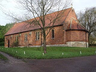
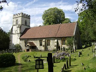
St. Paul's Church, in High Street, West Wycombe, England, is one of two Anglican churches in the village.
Camberley Obelisk is a brick tower at the top of a hill in Camberley, Surrey, England. The tower was built by John Norris (1721–1786) in about 1765–1770. The top section of the tower was destroyed by fire in the early 1880s. It is a Grade II listed building.