Cadmore

Last updated

Cadmore
Cadmore End Church - geograph.org.uk - 835146.jpg
Church of England parish church of St Mary-le-Moor, Cadmore End, 2008
Buckinghamshire UK location map.svg
Red pog.svg
Cadmore
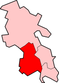
Location within Buckinghamshire
OS grid reference SU785925
Unitary authority
Ceremonial county
Region
Country England
Sovereign state United Kingdom
Post town HIGH WYCOMBE
Postcode district HP14
Dialling code 01494
Police Thames Valley
Fire Buckinghamshire
Ambulance South Central
List of places
UK
England
Buckinghamshire
51°37′34″N0°52′01″W / 51.626°N 0.867°W / 51.626; -0.867 Coordinates: 51°37′34″N0°52′01″W / 51.626°N 0.867°W / 51.626; -0.867

Cadmore, also known as Cadmore End, is a village in the civil parish of Lane End in the English county of Buckinghamshire.

Historically Cadmore End was in two parishes and two counties. Part was a detached part of the parish of Lewknor in Oxfordshire, part of a division of the parish known as Lewknor Uphill consisting of three detached parts. [1] Part of Cadmore End was a manor in the parish of Fingest in Buckinghamshire. [2] In 1852 it became the separate ecclesiastical parish of Cadmore End, and in 1896 the Oxfordshire part of the parish was transferred to Buckinghamshire.

The parish church of St Mary le Moor was built in 1851 and is a Grade II listed building. [3] It replaced the mediaeval chapel with the same dedication at Ackhampstead.

Related Research Articles

<span class="mw-page-title-main">Fingest</span> Human settlement in England

Fingest is a village in Buckinghamshire, England. It is in the Chiltern Hills near the border with Oxfordshire. It is about six miles WSW of High Wycombe. It lies in the civil parish of Hambleden.

<span class="mw-page-title-main">Hambleden</span> Human settlement in England

Hambleden is a small village and civil parish in south-west Buckinghamshire, England. The village is around 4 miles (6.4 km) west of Marlow, and around 3 miles (4.8 km) north-east of Henley-on-Thames in Oxfordshire.

Lane End is a village and civil parish in Buckinghamshire, England. It is just south of the M40 from High Wycombe, about 2 miles (3.2 km) west of Booker. The village is twinned with Saint-Pierre-d'Oléron in France.

<span class="mw-page-title-main">Lillingstone Lovell</span> Human settlement in England

Lillingstone Lovell is a village and civil parish in north Buckinghamshire, England. It is located around 4 miles (6.4 km) north of Buckingham and 8 miles (13 km) west of Milton Keynes, and around 5 miles (8 km) south of Towcester in the neighbouring county of Northamptonshire. Silverstone Circuit is located just over 2 miles (3.2 km) north-west of Lillingstone Lovell.

<span class="mw-page-title-main">Pishill</span> Human settlement in England

Pishill is a hamlet in Pishill with Stonor civil parish about 5 miles (8 km) north of Henley-on-Thames in South Oxfordshire. It is in the Stonor valley in the Chiltern Hills about 430 feet (130 m) above sea level.

<span class="mw-page-title-main">Counties (Detached Parts) Act 1844</span> United Kingdom legislation

The Counties Act 1844, which came into effect on 20 October 1844, was an Act of Parliament of the United Kingdom which eliminated many outliers or exclaves of counties in England and Wales for civil purposes. The changes were based on recommendations by a boundary commission, headed by the surveyor Thomas Drummond and summarized in a schedule attached to the Parliamentary Boundaries Act 1832. This also listed a few examples of civil parishes divided by county boundaries, most of which were dealt with by later legislation.

<span class="mw-page-title-main">South Weston</span> Human settlement in England

South Weston is a village in Lewknor civil parish, about 4.5 miles (7 km) south of Thame in Oxfordshire. There are about 19 households in the parish.

<span class="mw-page-title-main">Wheatfield, Oxfordshire</span> Human settlement in England

Wheatfield is a civil parish and deserted medieval village about 4 miles (6.4 km) south of Thame in Oxfordshire. Wheatfield's toponym is derived from the Old English for "white field", referring to the ripe crops that the Anglo-Saxons grew on its fertile land. Few of Wheatfield's buildings remain today except the Church of England parish church of Saint Andrew, the former rectory and the former outbuildings of the no-longer-standing manor house.

<span class="mw-page-title-main">Christmas Common</span> Hamlet in Oxfordshire, England

Christmas Common is a hamlet in Watlington civil parish, Oxfordshire about 7+12 miles (12 km) south of Thame in Oxfordshire, close to the boundary with Buckinghamshire. The hamlet is 812 feet (247 m) above sea level on an escarpment of the Chiltern Hills. Because of its elevation, Christmas Common has two radio masts that are prominent local landmarks.

<span class="mw-page-title-main">Emmington</span> Human settlement in England

Emmington is a village in Chinnor civil parish about 4.5 miles (7 km) southeast of Thame in Oxfordshire.

<span class="mw-page-title-main">Lewknor</span> Human settlement in England

Lewknor is a village and civil parish about 5 miles (8 km) south of Thame in Oxfordshire.The civil parish includes the villages of Postcombe and South Weston. The 2011 Census recorded the parish's population as 663.

<span class="mw-page-title-main">Pyrton</span> Village in Oxfordshire, England

Pyrton is a small village and large civil parish in Oxfordshire about 1 mile (1.6 km) north of the small town of Watlington and 5 miles (8 km) south of Thame. The 2011 Census recorded the parish's population as 227. The toponym is from the Old English meaning "pear-tree farm".

<span class="mw-page-title-main">Mixbury</span> Human settlement in England

Mixbury is a village and civil parish in Oxfordshire, about 2.5 miles (4 km) southeast of Brackley in Northamptonshire.

<span class="mw-page-title-main">Stonor</span> Human settlement in England

Stonor is a mostly cultivated and wooded village centred 3.8 miles (6.1 km) north of Henley-on-Thames in South Oxfordshire, England. It takes up part of the Stonor valley in the Chiltern Hills which rises to 120 meters above sea level within this south-east part of the civil parish. Stonor House close to the village centre has been the home of the Stonor family for more than eight centuries. The house and park are open to the public at certain times of the year. The house has a 12th-century private chapel built of flint and stone, with an early brick tower. There are also signs of a prehistoric stone circle in the park, which gives the place name its etymology.

<span class="mw-page-title-main">Stoke Talmage</span> Human settlement in England

Stoke Talmage is a village and civil parish 4+12 miles (7 km) south of Thame in Oxfordshire. The 2001 Census recorded the parish population as 49. Because the parish population is below 100, the 2011 Census combined its figures with the output area for the civil parishes of Adwell and Shirburn.

<span class="mw-page-title-main">Shirburn</span> Village in Oxfordshire, England

Shirburn is a village and civil parish about 6 miles (10 km) south of Thame in Oxfordshire. It contains the Grade I listed, 14th-century Shirburn Castle, along with its surrounding, Grade II listed park, and a parish church, the oldest part of which is from the Norman period. The parish has a high altitude by county standards. Its eastern part is in the Chiltern Hills Area of Outstanding Natural Beauty. Shirburn, the largest civil parish in the district, is forested to the south. A motorway cuts across one edge.

<span class="mw-page-title-main">Pishill with Stonor</span>

Pishill with Stonor is a civil parish in the high Chilterns, South Oxfordshire. It includes the villages of Pishill and Stonor, and the hamlets of Maidensgrove and Russell's Water. Pishill with Stonor was formed by the merger of the separate civil parishes of Pishill and Stonor in 1922. In 2011 it had a human population of 304 across its 10.54 km².

Ackhampstead or 'The Moor' was an ancient township in the Chiltern Hills, south of Lane End.

References

  1. Lobel, Mary D. (ed.) (1964). Victoria County History: A History of the County of Oxford, Volume 8. pp. 98–115.{{cite book}}: |author= has generic name (help)
  2. Page, William, ed. (1925). Victoria County History of Buckinghamshire: Volume 3: Fingest. pp. 42–45.
  3. British Listed Buildings website