Owlswick

Last updated

St Peters Chapel. St Peters Chapel - geograph.org.uk - 42833.jpg
St Peters Chapel.
Victorian Pillar box in Owlswick. Victorian Pillar box in Owlswick - geograph.org.uk - 43219.jpg
Victorian Pillar box in Owlswick.
Working windpump near Owlswick. Working windpump near Owlswick - geograph.org.uk - 43221.jpg
Working windpump near Owlswick.

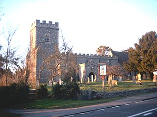
Owlswick is a hamlet in Buckinghamshire, England, about 3 miles E of Thame and 4 miles SSE of Aylesbury. It is part of the civil parish of Longwick-cum-Ilmer and is in the ecclesiastical parish of Monks Risborough.

Hamlet (place) Small human settlement in a rural area

A hamlet is a small human settlement. In different jurisdictions and geographies, hamlets may be the size of a town, village or parish, be considered a smaller settlement or subdivision or satellite entity to a larger settlement. The word and concept of a hamlet have roots in the Anglo-Norman settlement of England, where the old French hamlet came to apply to small human settlements. In British geography, a hamlet is considered smaller than a village and distinctly without a church or other place of worship.

Buckinghamshire County of England

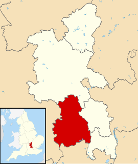
Buckinghamshire, abbreviated Bucks, is a ceremonial county in South East England which borders Greater London to the south east, Berkshire to the south, Oxfordshire to the west, Northamptonshire to the north, Bedfordshire to the north east and Hertfordshire to the east.

Thame market town and civil parish in South Oxfordshire district, Oxfordshire, England

Thame is a market town and civil parish in Oxfordshire, about 13 miles (21 km) east of the city of Oxford and 10 miles (16 km) southwest of the Buckinghamshire town of Aylesbury. It derives its name from the River Thame which flows along the north side of the town. The parish includes the hamlet of Moreton south of the town. The 2011 Census recorded the parish's population as 11,561.

The name appears in a document of about 1200 as Ulveswike, meaning the dairy farm of Ulf, which was a Danish personal name. The district is well to the south of the Danelaw, but a man of Danish origin may have come south and settled here. [1]

Danelaw Historical name given to part of England ruled by the Danes

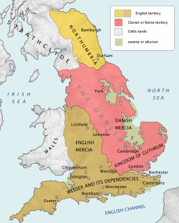
The Danelaw, as recorded in the Anglo-Saxon Chronicle, is a historical name given to the part of England in which the laws of the Danes held sway and dominated those of the Anglo-Saxons. Danelaw contrasts with West Saxon law and Mercian law. The term is first recorded in the early 11th century as Dena lage. Modern historians have extended the term to a geographical designation. The areas that constituted the Danelaw lie in northern and eastern England.

The hamlet was not mentioned in Domesday Book in 1086 because it formed part of the manor of Monks Risborough. It was later subinfeudated (i.e. granted as a feudal sub-manor) to a military subtenant and was held by knight-service by the 13th century. It continued as a separate sub-manor, paying a quit-rent to the manor of Monks Risborough until copyhold tenure was abolished in 1925. [2]

Domesday Book 11th-century survey of landholding in England as well as the surviving manuscripts of the survey

Domesday Book is a manuscript record of the "Great Survey" of much of England and parts of Wales completed in 1086 by order of King William the Conqueror. The Anglo-Saxon Chronicle states:

Then, at the midwinter [1085], was the king in Gloucester with his council .... After this had the king a large meeting, and very deep consultation with his council, about this land; how it was occupied, and by what sort of men. Then sent he his men over all England into each shire; commissioning them to find out "How many hundreds of hides were in the shire, what land the king himself had, and what stock upon the land; or, what dues he ought to have by the year from the shire."

Monks Risborough village in United Kingdom

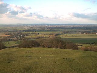
Monks Risborough is a village and ecclesiastical parish in Buckinghamshire, England, lying between Princes Risborough and Great Kimble. The village lies at the foot of the northern scarp of the Chiltern Hills. It is 8 miles (13 km) south of the county town of Aylesbury and 9.5 miles (15.3 km) north of High Wycombe, on the A4010 road.

Knight-service was a form of feudal land tenure under which a knight held a fief or estate of land termed a knight's fee from an overlord conditional on him as tenant performing military service for his overlord.

Related Research Articles

Great and Little Kimble cum Marsh civil parish in Wycombe, Buckinghamshire, England

Great and Little Kimble cum Marsh, formerly Great and Little Kimble is a civil parish in Wycombe district, Buckinghamshire. It is located 5 mi (8.0 km) to the south of Aylesbury. In addition to the villages of Great Kimble and Little Kimble it contains the hamlets of Kimblewick and Marsh, and an area within Great Kimble is called Smokey Row.

Wycombe District Non-metropolitan district in England

Wycombe is a local government district in Buckinghamshire in south-central England. Its council is based in the town of High Wycombe.

Princes Risborough town and civil parish in Buckinghamshire, England

Princes Risborough is a small town in Buckinghamshire, England, about 9 miles south of Aylesbury and 8 miles north west of High Wycombe. Bledlow lies to the west and Monks Risborough to the east. It lies at the foot of the Chiltern Hills, at the north end of a gap or pass through the Chilterns, the south end of which is at West Wycombe. The A4010 road follows this route from West Wycombe through the town and then on to Aylesbury.

Whiteleaf, Buckinghamshire human settlement in United Kingdom

Whiteleaf is a hamlet in the civil parish of Princes Risborough and the ecclesiastical parish of Monks Risborough in Buckinghamshire, England. It is located 7 miles south of the county town of Aylesbury and 8 miles north of High Wycombe. It lies halfway up the northern scarp of the Chilterns, about half a mile from the parish church of Monks Risborough.

Ashendon village in the United Kingdom

Ashendon is a village and civil parish in Buckinghamshire, England. It is about nine miles west of Aylesbury and seven miles north of Thame.

Bledlow village in United Kingdom

Bledlow is a village in the civil parish of Bledlow-cum-Saunderton in Buckinghamshire, England. It is about 1 12 miles (2.4 km) WSW of Princes Risborough, and is on the county boundary with Oxfordshire.

Horsenden is a hamlet in Wycombe district, Buckinghamshire, England and is in the civil parish of Longwick-cum-Ilmer. It is approximately one mile West of Princes Risborough, seven miles south of Aylesbury and three miles east of Chinnor in Oxfordshire. The Icknield Way passes just to the north of the village from north-east to south-west, although there is no connecting road through the hamlet itself.

Hundridge is a hamlet in the parish of Chartridge, in Buckinghamshire, England. It is located in the Chiltern Hills to the west of the town of Chesham. During the 14th century it was known as Hunderugge, and Hundrige in the 15th/16th century. The hamlet name derives from either the Anglo Saxon hunda-hrycg meaning 'hounds' ridge', or from Hundan-hrycg meaning 'Hunda's ridge'.

Meadle human settlement in United Kingdom

Meadle is a hamlet in the civil parish of Longwick-cum-Ilmer, in Buckinghamshire, England. It is located to the north of the village of Monks Risborough and near Little Kimble. The current population of Meadle is about 75. Most of the buildings are very old: farmhouses and labourers' cottages build in traditional red clay brick with thatched roofs. A small stream rises in the village and ultimately joins the Thames.

Radclive village in United Kingdom

Radclive is a village on the River Great Ouse just over 1 mile (1.6 km) west of Buckingham in Buckinghamshire, England. It is in the civil parish of Radclive-cum-Chackmore in Aylesbury Vale district. The parish includes the hamlet of Chackmore about 1.5 miles (2.4 km) north of Buckingham.

Saunderton village in United Kingdom

Saunderton is a village in the Saunderton Valley in the Chiltern Hills, Buckinghamshire, England. It is in the civil parish of Bledlow-cum-Saunderton, about 3 12 miles (6 km) northwest of High Wycombe and about 4 12 miles (7 km) south of Princes Risborough. It is on the A4010 road, and is served by Saunderton railway station on the Chiltern Main Line.

Whiteleaf Cross

Whiteleaf Cross is a cross-shaped chalk hill carving, with a triangular base, on Whiteleaf Hill in Whiteleaf near Princes Risborough in Buckinghamshire.

Desborough Hundred

Desborough Hundred is a hundred in Buckinghamshire, England. It is situated in the south of the county and is bounded on the west by Oxfordshire and on the south the River Thames marked the boundary with Berkshire.

Aylesbury (UK Parliament constituency) Parliamentary constituency in the United Kingdom, 1885 onwards

Aylesbury is a constituency created in 1553 — created as a single-member seat in 1885 — represented in the House of Commons of the United Kingdom since 1992 by David Lidington, of the Conservative Party.

Saunderton railway station British railway station

Saunderton railway station is a railway station on the A4010 road between High Wycombe and Princes Risborough, in Buckinghamshire, England. It is located near the villages of Bledlow Ridge and Bradenham, and lies on the Chiltern Main Line between High Wycombe and Princes Risborough stations.

Parmoor human settlement in United Kingdom

Parmoor is a hamlet to the south of Frieth in the parish of Hambleden, in Buckinghamshire, England. It has a Site of Special Scientific Interest, Fayland Chalk Bank.

A4010 road road in Buckinghamshire, England

The A4010 is an important primary north-south road in Buckinghamshire, Southern England. It runs from High Wycombe at Junction 4 of the M40 motorway to Stoke Mandeville, near Aylesbury on the A413.

Henton, Oxfordshire village in United Kingdom

Henton is a hamlet in Oxfordshire, about 3 miles (5 km) west of Princes Risborough in Buckinghamshire. Henton is in the civil parish of Chinnor, just off the Icknield Way, which has been a road since the Iron Age.

Aylesbury Vale Non-metropolitan district in England

The Aylesbury Vale is a large area of gently rolling agricultural landscape in the northern half of Buckinghamshire, England. Its boundary is marked by the Borough of Milton Keynes and South Northamptonshire to the north, Central Bedfordshire and the Borough of Dacorum (Hertfordshire) to the east, the Chiltern Hills and Wycombe to south, and South Oxfordshire to the west. The vale is named after Aylesbury, the county town of Buckinghamshire. The two other towns which lie within the vale are Winslow and Buckingham.

References

  1. Mawer & Stenton: The Place Names of Buckinghamshire (Cambridge 1925)
  2. Victoria History of the County of Buckingham Vol.2 (1908) p.257

Coordinates: 51°44′56″N0°51′31″W / 51.74895°N 0.85850°W / 51.74895; -0.85850

Geographic coordinate system Coordinate system

A geographic coordinate system is a coordinate system that enables every location on Earth to be specified by a set of numbers, letters or symbols. The coordinates are often chosen such that one of the numbers represents a vertical position and two or three of the numbers represent a horizontal position; alternatively, a geographic position may be expressed in a combined three-dimensional Cartesian vector. A common choice of coordinates is latitude, longitude and elevation. To specify a location on a plane requires a map projection.