
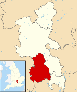
Buckinghamshire, abbreviated Bucks., is a ceremonial county and (smaller) unitary authority area of the same name in South East England which borders Greater London to the south east, Berkshire to the south, Oxfordshire to the west, Northamptonshire to the north, Bedfordshire to the north east and Hertfordshire to the east.

In British town planning, the green belt is a policy for controlling urban growth. The idea is for a ring of countryside where urbanisation will be resisted for the foreseeable future, maintaining an area where agriculture, forestry and outdoor leisure can be expected to prevail. The fundamental aim of green belt policy is to prevent urban sprawl by keeping land permanently open, and consequently the most important attribute of green belts is their openness.

High Wycombe, often referred to as Wycombe, is a large market town in Buckinghamshire, England. Lying in the valley of the River Wye surrounded by the Chiltern Hills, it is 29 miles (47 km) west north west of Charing Cross in London; this information is also engraved on the Corn Market building in the centre of the town. It is also 13.2 miles (21.2 km) south-south-east of the county town of Aylesbury, 23.4 miles (37.7 km) southeast of Oxford, 15.4 miles (24.8 km) north east of Reading and 7.7 miles (12.4 km) north of Maidenhead. According to the ONS official estimates for 2016, High Wycombe has a population of 125,257 and it is the second largest town in the county of Buckinghamshire after Milton Keynes. High Wycombe Urban Area, the conurbation of which the town is the largest component, has a population of 133,204.
A greenbelt is a policy and land use zone designation used in land use planning to retain areas of largely undeveloped, wild, or agricultural land surrounding or neighboring urban areas. Similar concepts are greenways or green wedges which have a linear character and may run through an urban area instead of around it. In essence, a green belt is an invisible line designating a border around a certain area, preventing development of the area and allowing wildlife to return and be established.
The Chiltern Hills or, as they are known locally and historically, the Chilterns, is a range of hills northwest of London. They form a chalk escarpment across Oxfordshire, Buckinghamshire, Hertfordshire, and Bedfordshire. A large portion of the hills was designated officially as an Area of Outstanding Natural Beauty in 1965.
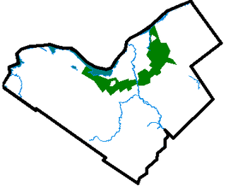
Wycombe District was a local government district in Buckinghamshire in south-central England. Its council was based in the town of High Wycombe. The district was abolished on 31 March 2020 and its area is now administered by the unitary Buckinghamshire Council.

Bourne End is a village mostly in the parish of Wooburn, but partly in the parish of Little Marlow, in Buckinghamshire, England. It is about five miles (8 km) south-east of High Wycombe and three miles (5 km) east of Marlow, near the border with Berkshire and close to where the River Wye empties into the Thames.

Lane End is a village and civil parish within Wycombe district in Buckinghamshire, England. It is just south of the M40 from High Wycombe, about two miles (3 km) west of Booker. The village is twinned with Saint-Pierre-d'Oléron in France.
Great Marlow is a civil parish within Wycombe district in the English county of Buckinghamshire located north of the town of Marlow and south of High Wycombe. The parish includes the hamlets of Bovingdon Green, Burroughs Grove, Chisbridge Cross and Marlow Common. Prior to November 2007 the major settlement in Great Marlow was Marlow Bottom which has now become a civil parish in its own right.

The Borough of Basildon is a local government district in south Essex in the East of England, centred on the town of Basildon. The district was formed under the Local Government Act 1972 on 1 April 1974 from the former area of Basildon Urban District and the part of Thurrock Urban District that was within the Basildon New Town. The population of the district as of 2010 is about 172,000. The council made an application for borough status in February 2010 and this was given approval that year, with Cllr Mo Larkin becoming the first mayor in October. The local authority is Basildon Borough Council.

Shipbourne is a village and civil parish situated between the towns of Sevenoaks and Tonbridge, in the borough of Tonbridge and Malling in the English county of Kent.

Alpheton is a village and civil parish in the Babergh district of Suffolk, England. Located on the A134 road about six miles north of Sudbury, in 2005 it had a population of 260, reducing to 256 at the 2011 Census. According to Eilert Ekwall the meaning of the village name is the homestead of Aelfled.

The Marlow branch line is a single track railway line in England, between Maidenhead in Berkshire and Bourne End and Marlow in Buckinghamshire. It is 7 miles 10 chains (11.5 km) in length. Passenger services are operated by Great Western Railway using Class 165 and Class 166 diesel trains. The line connects to the Great Western Main Line at Maidenhead station, and uses a section of the former Wycombe Railway line to High Wycombe together with the former Great Marlow Railway.
Conservation development, also known as conservation design, is a controlled-growth land use development that adopts the principle for allowing limited sustainable development while protecting the area's natural environmental features in perpetuity, including preserving open space landscape and vista, protecting farmland or natural habitats for wildlife, and maintaining the character of rural communities. A conservation development is usually defined as a project that dedicates a minimum of 50 percent of the total development parcel as open space. The management and ownership of the land are often formed by the partnership between private land owners, land-use conservation organizations and local government. It is a growing trend in many parts of the country, particularly in the Western United States. In the Eastern United States, conservation design has been promoted by some state and local governments as a technique to help preserve water quality.

Land banking is the practice of aggregating parcels of land for future sale or development.
The Wycombe Railway was a British railway between Maidenhead and Oxford that connected with the Great Western Railway at both ends; there was one branch, to Aylesbury.

Lawshall is a village and civil parish in Suffolk, England. Located around a mile off the A134 between Bury St Edmunds and Sudbury, it is part of Babergh district. The parish has nine settlements comprising the three main settlements of The Street, Lambs Lane and Bury Road along with the six small hamlets of Audley End, Hanningfield Green, Harrow Green, Hart's Green, Hibb's Green and Lawshall Green.
Development-supported agriculture is a nascent movement in real estate development that preserves and invests in agricultural land use. As farmland is lost due to the challenging economics of farming and the pressures of the real estate industry, DSA attempts to reconcile the need for development with the need to preserve agricultural land. The overall goal of DSA is to incubate small-scale organic farms that co-exist with residential land development, providing benefits to farmers, residents, the local community, and the environment.

An open space reserve is an area of protected or conserved land or water on which development is indefinitely set aside.

